
Pommerit-Jaudy
| Pommerit-Jaudy | ||
|---|---|---|
|
||
| local community | La Roche-Jaudy | |
| region | Brittany | |
| Department | Cotes-d'Armor | |
| Arrondissement | Lannion | |
| Coordinates | 48 ° 44 ′ N , 3 ° 14 ′ W | |
| Post Code | 22450 | |
| Former INSEE code | 22247 | |
| Incorporation | 1st January 2019 | |
| status | Commune déléguée | |

Pommerit_Jaudy ( Breton : Peurid-ar-Roc'h ) is a village and a former French commune with 1,213 inhabitants (at January 1, 2017) in Côtes-d'Armor in the region of Brittany . It belonged to the arrondissement of Lannion and the canton of Tréguier (until 2015 canton of La Roche-Derrien ). The residents refer to themselves as Pommeritain (e) s .
With effect from January 1, 2019, the former municipalities of La Roche-Derrien , Hengoat , Pommerit-Jaudy and Pouldouran were merged to form Commune nouvelle La Roche-Jaudy and have the status of a Commune déléguée in the new municipality . The administrative headquarters are in La Roche-Derrien.
geography
Pommerit-Jaudy is about 16 kilometers east of Lannion . In addition to the village of Pommerit-Jaudy, the Commune déléguée also includes numerous scattered settlements and individual farms. The neighboring towns are Hengoat, Langoat, La Roche-Derrien, Mantallot, Minihy-Tréguier, Ploëzal, Prat, Runan and Troguéry.
| La Roche-Derrien | Minihy-Tréguier |
Hengoat Troguéry |
|
Mantallot Langoat |
.svg)
|
Ploëzal |
| Prat | Runan | Runan |
history
The area has been settled for a long time. Finds from the Gallo-Roman period have been excavated in Pont-Rod. And an old vase was found in a tumulus in the community area. In the Middle Ages there was an infirmary for lepers in Penn-Krecy. Coat-Nevenez Castle, which no longer exists today, was built in the 9th and 10th centuries. The church of Pomerit jeudi is mentioned in connection with the canonization of Saint-Yves in 1330. As early as 1444, Pommerit-Jaudy was an independent parish. Field names such as Mouster (near the Saint-Adrien chapel) and Moustéro come from the properties of the Templars and Johanniter. After the French Revolution, the area was a refuge for the insurgent royalists (called Chouans).
Population development
The former municipality already had more than 2000 inhabitants before 1800. Until 1821 the number of residents grew only slightly. In the following ten years there was a surge in growth that raised the population to more than 2500 people. Until 1881 the population stayed at over 2500 people. The historic high was in 1856. Between 1881 and 1946 there was a marked decline in population (1881-1946: -50.6%). After stabilizing until 1962, there was another wave of emigration (1962–1975: - 23.1%). The low of 958 residents in 1975 meant a drop from the high of 1856 of a whopping 64.2%. Between 1990 and 2008 there was a strong growth phase of 28.1%. The population now numbers just over 1200 people again.
| 1793 | 1800 | 1806 | 1821 | 1831 | 1836 | 1841 | 1846 | 1851 | 1856 | 1861 | 1866 | 1872 | 1876 | 1881 | 1886 | 1891 | 1896 |
|---|---|---|---|---|---|---|---|---|---|---|---|---|---|---|---|---|---|
| 2,170 | 2,232 | 2,308 | 2,303 | 2,524 | 2,552 | 2,542 | 2,557 | 2,583 | 2,679 | 2,655 | 2,652 | 2,631 | 2,558 | 2,523 | 2,266 | 2,169 | 2,085 |
| 1901 | 1906 | 1911 | 1921 | 1926 | 1931 | 1936 | 1946 | 1954 | 1962 | 1968 | 1975 | 1982 | 1990 | 1999 | 2008 | 2013 |
|---|---|---|---|---|---|---|---|---|---|---|---|---|---|---|---|---|
| 2,046 | 1,945 | 1,906 | 1,739 | 1,675 | 1,558 | 1,412 | 1,246 | 1,218 | 1,202 | 1,036 | 958 | 959 | 972 | 990 | 1,227 | 1,235 |

Attractions
- Manor of Coat-Nevenez (from the 16th century in 1944 rebuilt)
- 17th century mansion of Cosquer
- Mansion Kersaliou , with porch from the 14th century
- Le Chef-du-Bois Castle in Pen-ar-Hoat (built 1867)
- Kermezen Castle from the 13th-17th centuries Century; with house chapel
- Saint-Pierre-ès-Liens village church (built in 1913)
- seven chapels; all built between the 16th and 18th centuries
- Saint Adrien ossuary
- Calvary Croix-Rouge (also Croas-Ru; 1545)
- Crosses and wayside crosses in Kermezen (17th century), Saint-Antoine (18th century), Ty-Glas-Bras (18th century), Kericuff (17th century), Quillevez-Braz (17th century) and Quillevez (with Calvary)
- numerous old farms; Ty-Glas-Bras (1743), Kermenguy (1781), Kervilgos (1716), Kervellec (1773), Lézonan (1706), Kerrouel (1654), Le petit ChefduBois, Coat-Rogan (16th century), Kerré (1771 ), Lescop (18th century)
- eleven mills in Kermezen, Bourette, Penancoat, Coat-Nevez (also Coat-Nevenez), Trojody, Poulohou, Paul, Le Rumain and Trézéan
- Dovecote in Kéricuff (Kericuf)
- Pont du Launay bridge by the architect Louis Harel de La Noé
- Bridge of the château de Kermezen , built by Gustave Eiffel
- Stele in Pabu in memory of eleven members of the Resistance who were killed in 1944

Town hall (Mairie) of Pommerit-Jaudy

Saint-Pierre-ès-Liens village church
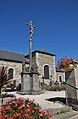
Calvary in the village cemetery
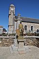
Memorial to the Fallen
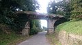
The Chef-du-bois bridge
.JPG)
.JPG)
.JPG)
.JPG)

literature
- Le Patrimoine des Communes des Côtes-d'Armor. Flohic Editions, Volume 2, Paris 1998, ISBN 2-84234-017-5 , pp. 1155-1159.
Individual evidence
- ^ Decree of the prefecture on the formation of the Commune nouvelle La Roche-Jaudy of October 29, 2018 in RAA Spécial No. 91.