
Prince head
| Prince head | ||
|---|---|---|
.jpg) Prinzenkopf from the north, taken from the banks of the Moselle near Alf |
||
| height | 235.5 m above sea level NHN | |
| location | Moselle valley near Pünderich , Cochem-Zell district , Rhineland-Palatinate ( Germany ) | |
| Coordinates | 50 ° 2 '49 " N , 7 ° 7' 44" E | |
|
||
| Type | Umlaufberg | |
| particularities | Prinzenkopf tower , Prinzenkopf tunnel | |

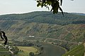
The Prinzenkopf is 235.5 m above sea level. NHN high mountain in the local community of Pünderich on the Moselle in the Rhineland-Palatinate district of Cochem-Zell . It is about 700 m away from the Marienburg and is located on a 500 m narrow narrowing of a Moselle loop that leads around the Zell district of Barl . According to other older sources, the mountain height is also 237.5 m above sea level. NHN indicated.
Prince's head tower
As early as 1888 there was a wooden observation tower on the Prinzenkopf , which was replaced by a stone tower in 1899. This was destroyed in 1945 after being blown up by the American army . A wooden observation tower erected in 1983 was dismantled in September 2008 to be replaced by a steel structure as a new observation tower. It was opened for use on May 31, 2009, on which day 974 visitors climbed the tower.
From the Prinzenkopf tower there is a broad view over the Moselle loop and the villages of Pünderich, Reil , Alf , Alf-Fabrik, Bullay , Zell and Marienburg.
The mobile operator Telefonica Deutschland operates a BTS (Base Transceiver Station) on the tower, which supplies the villages of Bullay, Alf and Plünderich with GSM (2G). Broadband expansion with LTE is not yet planned at this location. When the old tower was demolished, the antenna system was replaced by a temporary station around 50 m below the tower location for the duration of the work.

tunnel
The Prinzenkopf Tunnel (459 m), which runs under the Prinzenkopf and was built in 1878 as part of the Kanonenbahn , and the associated longest slope viaduct in Germany (786 m, built in 1880) is noteworthy . The vaulted bridge has 92 openings with a clear width of 7.2 meters. To the north of the tunnel is the Alf-Bullay double-decker bridge (1877/1878), Germany's first combined rail and road bridge on the Moselle route from Alf to Bullay.
Cemetery of honor
There is a cemetery of honor northwest of the observation tower. Here are the dead from the fights for the prince's head from 12th to 17th Buried March 1945.
Hiking trails
The area around the Prinzenkopf is accessible by numerous hiking trails. The long-distance hiking trail Moselsteig runs from Reil over the Prinzenkopf to Barl and on to Zell. The Kanonenbahn cultural hiking trail, which leads from Bullay to Reil via the Prinzenkopf, has existed since September 2005 . He uses the so-called Red Path from Pünderich to Alf on part of the route . The red path takes its name from the red earth on the slope. The path leads past the bicentennial Three Oaks , a natural monument since 1938.
Refuge huts are the Drieschhütte and the hut on the Dünwald-Höhe (not managed).
Not far from the Prinzenkopf is the Leofelsen with a refuge of the same name. A hiking trail leads over a narrow ridge towards Arras Castle .
Picture gallery
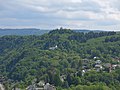
View of the Prinzenkopf from the north-northwest
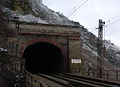
Prinzenkopf tunnel (entrance south-west)
Slope viaduct
.jpg)


Web links
Individual evidence
- ↑ Map service of the landscape information system of the Rhineland-Palatinate Nature Conservation Administration (LANIS map) ( notes ) (scale 1: 1,000)
- ↑ Map services of the Federal Agency for Nature Conservation ( information )
- ^ Photo of the information board on the tower, on commons.wikimedia.org