Puerto Rondón
| Puerto Rondón | ||
|---|---|---|
|
Coordinates: 6 ° 17 ′ N , 71 ° 6 ′ W Puerto Rondón on the map of Colombia
|
||
|
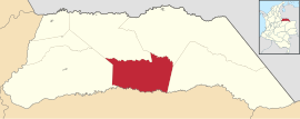
Location of the municipality of Puerto Rondón on the map of Arauca
|
||
| Basic data | ||
| Country | Colombia | |
| Department | Arauca | |
| City foundation | 1921 | |
| Residents | 3820 (2019) | |
| City insignia | ||
| Detailed data | ||
| surface | 2186 km 2 | |
| Population density | 2 people / km 2 | |
| height | 190 m | |
| Waters | Río Casanare | |
| Time zone | UTC -5 | |
| City Presidency | Sandra Milena Gutierrez Vigott (2016–2019) | |
| Website | ||
| Central Park of Puerto Rondón | ||
| Church in Puerto Rondón | ||
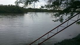
| The Río Casanare near Puerto Rondón | ||
Puerto Rondon is a municipality ( municipio ) of the departments of Arauca in Colombia .
geography
Puerto Rondón is located in the south of Araucas in the Colombian Llanos on the Río Casanare at an altitude of 190 m above sea level. NN , 230 km from the city of Arauca . In addition, the Río Cravo Norte flows through the municipality. The municipality borders in the north on the municipality of Arauca and Arauquita , in the west on Tame , in the east on Cravo Norte and in the south on Hato Corozal in the Departamento de Casanare .
population
The municipality of Puerto Rondón has 3820 inhabitants, of which 2856 live in the urban part (cabecera municipal) of the municipality (as of 2019).
history
Puerto Rondón was founded by the Venezuelan cattle farmer Luis Felipe Hernández on the Río Casanare and received the status of a corregimientos (administrative subunit ) in 1921 . Puerto Rondón has had the status of a municipality since 1987.
economy
The main industry in Puerto Rondón is cattle production , which employs 80% of the population and generates 90% of its income. The cattle graze on the vast plains of the community. Agriculture has so far only taken place on a smaller scale.
Transport links
Puerto Rondón has a small regional airport. There are daily flight connections to Arauca. Yopal , Villavicencio and Tame also fly to Puerto Rondón sporadically . There are road connections via Tame to almost all municipalities in the department and to the neighboring departments. There is a boat connection to Cravo Norte via the Río Casanare.
Web links
- Alcaldía Municipal de Puerto Rondón en Arauca. Alcaldía de Puerto Rondón - Arauca, accessed on May 15, 2019 (Spanish, website of the municipality of Puerto Rondón).
Individual evidence
- ^ Geografía del municipio. Alcaldía de Puerto Rondón - Arauca, accessed on May 15, 2019 (Spanish, information on the geography of the municipality).
- ↑ ESTIMACIONES DE POBLACIÓN 1985 - 2005 Y PROYECCIONES DE POBLACIÓN 2005 - 2020 TOTAL DEPARTAMENTAL POR ÁREA. (Excel; 1.72 MB) DANE, May 11, 2011, accessed on May 15, 2019 (Spanish, extrapolation of the population of Colombia).
- ↑ Information about the history on the official website of Puerto Rondón (Spanish)
- ↑ Information about the economy on the official website of Puerto Rondón (Spanish)
- ↑ Vías de comunicación. Alcaldía de Puerto Rondón - Arauca, accessed on May 15, 2019 (Spanish, information on the infrastructure of the municipality).


