Puerto Barrios
| Puerto Barrios | ||
|---|---|---|
|
Coordinates: 15 ° 44 ′ N , 88 ° 36 ′ W Puerto Barrios on the map of Guatemala
|
||
| Basic data | ||
| Country | Guatemala | |
| Department | Izabal | |
| City foundation | 1895 | |
| Residents | 60,000 | |
| City insignia | ||
| Detailed data | ||
| surface | 1292 km 2 | |
| Population density | 46 people / km 2 | |
| height | 3 m | |
| Waters | Bahia de Amatique | |
| Post Code | 18001 | |
| Time zone | UTC −6 | |
| Website | ||
| Puerto Barrios on the Gulf of Honduras | ||
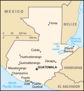
| Map of Guatemala with Puerto Barrios | ||
Puerto Barrios is a port city on the Caribbean coast of Guatemala . Puerto Barrios is the administrative seat of the municipality of the same name and the capital of the department of Izabal . The city was named after the former Guatemalan President Justo Rufino Barrios Auyón .
geography
With around 60,000 inhabitants, Puerto Barrios is the largest port city on Guatemala's narrow gateway to the Caribbean. The city is located 297 km northeast of Guatemala City at the foot of the Montañas del Mico, an extension of the Sierra de las Minas , on the Bahía de Amatique, a bay in the Gulf of Honduras , not far from the mouth of the Río Motagua .
The 1,292 km² municipality has about 100,000 inhabitants in five subordinate municipalities ( Aldeas ), including Santo Tomás de Castilla (Matias de Gálvez). It borders in the north on the Caribbean, in the southeast on Honduras , in the southwest on the Municipio Morales and in the west on Livingston (both to Izabal).
history
The idea of building a large seaport on the Caribbean coast to improve the economic development of the country and connecting it to Guatemala City and Puerto San José on the Pacific by a railway line was put into practice by the liberal reformer and President Justo Rufino Barrios from 1883 . The city was inaugurated in 1895, ten years after Barrios' death, the rail connection after several delays not until 1908. Both the port and the railroad soon became dependent on the all-powerful United Fruit Company . In its heyday, all Guatemalan banana exports were handled through this port. With the decline of their banana empire in the 1960s, Puerto Barrios began to decline, compounded by a major earthquake in 1976. The reconstruction of the seaport took place a few kilometers southwest, in Santo Tomás de Castilla , where some Belgians had settled from 1843–1854 .
Economy and Transport
Puerto Barrios has never really recovered after its decline in the 1960s and in particular because of the extensive relocation of commercial sea traffic to Santo Tomás. The cruise ships that are supposed to help inland tourism get on their feet also dock in Santo Tomás. Tourists then make short detours to Petén ( Tikal ) or to destinations in the highlands via the recently modernized Puerto Barrios Airport . In terms of local tourism, too, Puerto Barrios is only a stopover for boat trips to Livingston and Punta Gorda (Belize) . The city is the end point of the CA 9 ( Carretera Interoceanica ) highway, which is chronically overloaded by heavy traffic and has so far only been partially developed into a motorway , which leads from Puerto San José on the Pacific via Guatemala City to the Caribbean. The railway line running next to it is currently not in operation.
military
The headquarters of the Kaibiles , a special unit of the armed forces of Guatemala , has been located in Puerto Barrios since 2008 . In Santo Tomás there is a naval base with the Comando Naval del Caribe . Puerto Barrios Airport has a military part.
Attractions
Historically interesting in the city of Puerto Barrios itself are some buildings from the time of its earlier heyday: old warehouses, the wooden Hotel del Norte with its historical interior and a tomb in the form of a scaled-down Taj Mahal. In the Bahia de Amatique, the Punta Manabique peninsula with its mangrove forests is an attraction. Not from the industrial port in Puerto Barrios, but from the Muelle Municipal jetty , boats go to Livingston and on through the Río Dulce to Lake Izabal . The Maya ruins of Quiriguá are located just under 100 kilometers southwest of Puerto Barrios .


