
Rateče
|
Rateče Ratschach |
|||||
|
|||||
| Basic data | |||||
|---|---|---|---|---|---|
| Country |
|
||||
| Historic region | Upper Carniola / Gorenjska | ||||
| Statistical region | Gorenjska (Upper Carniola) | ||||
| local community | Kranjska Gora | ||||
| Coordinates | 46 ° 30 ' N , 13 ° 43' E | ||||
| height | 870 m. i. J. | ||||
| Residents | 648 (2002) | ||||
| License Plate | KR | ||||


Rateče [ ˈratɛtʃɛ ] ( German Ratschach ) is a place in Slovenia .
geography

Rateče is located on the border triangle with Italy and Austria in the Savetal between the rugged mountain range of the Julian Alps in the south and the gentler Karawanken in the north. The valley is the Rateče saddle (Ratschacher saddle, Valico di Fusine) . The place is on the north slope, at the foot of the triangle (Monte Forno, Peč, 1508 m above sea level ), at 870 m above sea level. To the south rises the multi-peaked ridge of the Ponce (Visoka Ponca / Ponza Grande 2274 m )
The place is part of the Kranjska Gora municipality and has about 700 inhabitants.
Districts:
- Planica (German Ratschach-Matten ), the southward side valley, with Tamar
Neighboring places:
|
Seltschach (Gem. Arnoldstein , District Villach-Ld. , Ktn. , AT )
(Karawanken) |
||
| Fusine in Valromana (Gem. Tarvisio , Friuli-Jul. Veneto , IT ) |
.svg)
|
Podkoren |
history
Probably originated in Rateče in the second half of the 14th century , the manuscript of Rateče (kept in Klagenfurt ), a collection of formulas of prayer in Slovenian. The local dialect is the only one in Carniola that is assigned to Carinthian (see: Slovenian dialects ).
Until the end of the Habsburg Empire, the place belonged to the Kronland Carniola , with Rateče forming an independent municipality in the judicial district of Kronau (political district Radmannsdorf ).
Since the late 20th century, the population has lived mainly from tourism.
Winter sports
In the district of Planica (Ratschach-Matten in German) is the Letalnica bratov Gorišek , a ski flying hill on which numerous world records have been set.
Culture and sights
In the eastern part of the village is the parish church of the Holy Spirit with a late Gothic presbytery (original chapel from 1520). Further to the west is the cemetery church of St. Thomas with a bell tower from the 14th century and a bell from 1521. Inside there is a Way of the Cross (L. Layer) and the remains of Gothic wall paintings (Master of Zirivnica).
Also worth seeing is the Nadiža waterfall (Izvir Nadiža) on the Ponce ( 2242 m above sea level ), the first appearance of the Sava Dolinka . Towards Podkoren is the Zelenci lake with the Izvir Save spring waterfall as the actual source. The episodic Lake Ledine (Ratschacher See) sometimes forms south of the village . It is suitable for ice skating in winter. The Triglav National Park begins directly behind the Planica winter sports area .

St. Thomas cemetery church in Rateče
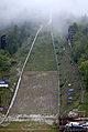
Ski flying hill in Planica


proof
- Kranjska Gora - Rateče-Planica, slovenia.info
- ↑ Nadiža waterfall. kranjska-gora.si, accessed October 1, 2015.
- ↑ Zelenci. kranjska-gora.si, accessed October 1, 2015.
- ↑ The Periodic Lake Ledine. kranjska-gora.si, accessed October 1, 2015.