
Rathenauplatz (Cologne)
The Rathenauplatz is a 2.77 hectare park in the Cologne-Neustadt-Süd district . It is located in Carré Roonstrasse, Zülpicher Strasse, Dasselstrasse and Lindenstrasse, surrounded by dense development.
Plant of the district
The area around the later Rathenauplatz was outside the city wall and served as an open field for agriculture. For several decades, the city council and citizens tried to break open the fortress that was encircling the city on an administrative level , until the demolition of the medieval city wall could begin in 1881. The twelve million marks to be paid to the tax authorities for the old wall were raised by selling property. The execution of the Cologne Neustadt according to the plans of the then city architect Josef Stübben followed immediately with the breaking of the first gap in the city wall.
A triangular park was to be created on Roonstrasse in the middle of the district. Stübben had designed it as a fairground, with a royal monument, flagpoles and fountain. However, the planned “ Volksgarten ” was finally realized elsewhere. Up until 1890, Roonstrasse was only moderately developed. Development on Lochner Strasse and Meister-Gerhard-Strasse was also just beginning, while Görresstrasse was only to be opened up a few years later. In the course of the expansion, parts of the site on the edge of the “Weyer- oder Kreuzkaul”, a swampy depression between the city wall and the first fortress paleon, became usable as building land through backfill . Because of the damp subsoil, the houses were built with double basements and are partially connected to each other via the basement floors.
Layout of the square

The remaining depression was a wetland and was too deep for building projects. Since there was nothing to do with this area, it was converted into a green area. A greening of the approx. 27,700 m² square, proposed by the municipal gardening director Adolf Kowallek, was implemented: All around an avenue with plane trees , in the middle a lawn edged with bushes. In total, more than 200 trees and 260 meters of flowering shrubs, especially lilacs , were planted. Children's playgrounds were set up at two points, and numerous benches provided sufficient seating. Appropriate paths were laid out to connect the square with the adjacent streets.
A naming of the square after King Friedrich Wilhelm IV of Prussia (1795–1861) failed in the council meeting in 1887, whereupon the name Königsplatz was agreed.
After the murder of Walther Rathenau in June 1922, the city council renamed Rathenauplatz at the request of the social democratic faction in 1923 .
Immediately after they came to power in 1933 , the Nazis replaced the name of this hated Jew and representative of the Weimar "system time" with that of their "martyr" Horst Wessel .
Since the end of the Nazi era, the square opposite the mighty synagogue building on Roonstrasse has been called Rathenauplatz again.
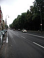
Roonstrasse, Rathenauplatz

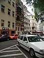
Rathenauplatz, detail
Rathenauplatz, south side

Rathenauplatz, west side


Initiatives
The place is often used for meetings and celebrations. That is why a citizens' initiative came together in 1977 to organize this, design the square and enrich it with its own actions. An open bookcase was set up in which non-commercial advertisements, for example for barter offers or private junk, can be published. She is also the operator of the local beer garden . The associated citizens' pavilion was awarded the: Cologne Architecture Prize in 2000. The pétanque friends Rathenauplatz have created a boules court .
Rathenauviertel
For example, while Kriel , Nippes or Mülheim became a Kölschen Veedel in the course of the incorporation from an independent municipality , this quarter was created on the drawing board as a result of the city expansion that began in 1881.
The residential area between Ringstrasse and the university is now officially called Rathenauviertel after the square in its center, but is also known as Zülpicher Viertel (after the start of Zülpicher Straße from Zülpicher Platz), as a university quarter because of its proximity to the university or as Kwartier Latäng .
In the Kwartier Latäng, alluding to the Parisian " Quartier Latin ", there are numerous small independent theaters, it is a neighborhood with trendy bars and restaurants with a variety of international cuisine. The Rathenauplatz eV community was founded in 1977 and has been running a beer garden in the park in the middle of the square since 2000.
Boisseréestrasse
after Sulpiz Boisserée (1793–1854), art connoisseur, collector and promoter of the cathedral fort.
Gorresstrasse
after Josef Görres (1776–1854), next to Sulpiz Boisserée and August Reichensperger one of the initiators of the Central Cathedral Building Association in Cologne .
Dasselstrasse
after Rainald von Dassel († 1167), Archbishop of Cologne
Lochnerstrasse

In 1442 Stefan Lochner painted the altar of the city patron, which is now in the cathedral .
Lochnerstrasse School
The Stephan Lochner Elementary School is now housed in a three-storey, representative brick building, which was built by city architect Friedrich Carl Heimann in 1897–99 . The building stands out due to the stepped gable that emphasizes its central axis. Such school buildings with their elaborate facade design were called “school palaces” in parlance at the time, as their architecture took up design elements of the palace.
Since the number of pupils is falling, part of the building is used by the nearby vocational college on Lindenstrasse .
Meister-Gerhard-Strasse
Master Gerhard von Ryle (around 1248) was Cologne's first master builder .
Heinsbergstrasse
Philipp von Heinsberg was Archbishop of Cologne from 1168 to 1191 .
Roonstrasse
Along the Roonstraße (after Albrecht von Roon ) opposite the synagogue on the Rathenauplatz, shielded from traffic by trees and bushes, people often play boules and pétanque in summer and watch the children play on the playground.


Roonstrasse synagogue
The Cologne synagogue , the building that defines the square, was built from 1895 to 1899 in the neo-Romanesque style based on designs by the Cologne architects Schreiterer & Below . Devastated in the Reichspogromnacht 1938, the Cologne architect Helmut Goldschmidt , one of the representatives of the modern Jewish sacred building of the post-war period in Germany, restored the church in 1958/59 .
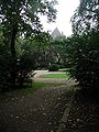
View through the park
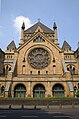
Roonstrasse synagogue


The interior was completely redesigned. The synagogue with its outbuildings is the religious and cultural center of the Cologne synagogue community . It is equipped with a mikvah (ritual bath), ballroom, memorial hall, museum and a kosher restaurant.
literature
- School through the ages - Lochnerstrasse School 1899–1974. Festschrift.
- Oliver Karnau: Hermann Josef Stübben, Urban Development 1876–1930. Braunschweig / Wiesbaden 1996, ISBN 3-528-08110-4 .
- Hiltrud Kier : The Cologne Neustadt. Planning, creation, use. (= Contributions to the architectural and art monuments in the Rhineland. Volume 23). Schwann, Düsseldorf 1978, ISBN 3-590-29023-4 .
- Heike Müller: Monument value and potential use of the city garden in Cologne. Thesis. TU Dresden, 2001.
- S. Roeseling: The brown Cologne. Emons-Verlag, Cologne 1999, ISBN 3-89705-141-9 .
- Anne Sass: More than just “Kwartier Latäng”. Life on Rathenauplatz. Cologne 1994, ISBN 3-7616-1133-1 .
- Sabine Simon: Schreiterer & Below-A Cologne architecture office between historicism and modernity. G. Mainz, Aachen 1999, ISBN 3-89653-475-0 .
Web links
Individual evidence
- ^ Hiltrud Kier: The Cologne Neustadt. Planning, creation, use. (= Contributions to the architectural and art monuments in the Rhineland. Volume 23). Schwann, Düsseldorf 1978, p. 168.
- ↑ buergergemeinschaft-rathenauplatz-ev.de
- ↑ tu-dresden.de History of landscape architecture and garden monument preservation
Coordinates: 50 ° 55 ′ 52 ″ N , 6 ° 56 ′ 10 ″ E