Ratscher (Schleusingen)
|
Ratchet
City of Schleusingen
Coordinates: 50 ° 29 ′ 47 " N , 10 ° 46 ′ 29" E
|
|
|---|---|
| Height : | 376 m |
| Residents : | 123 (Dec. 31, 2013) |
| Incorporation : | March 8, 1994 |
| Postal code : | 98553 |
| Area code : | 036841 |
|
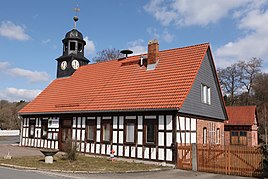
Old school
|
|
Ratscher is a district of the town of Schleusingen in the Hildburghausen district in Thuringia . In 2013 there were 123 inhabitants in the village.
location
Ratscher is located southeast of the town of Schleusingen and southwest of the federal highway 73 in the hilly terrain of the southern foothills of the Thuringian Forest . In terms of traffic, the place is connected to the state road 3004. The Ratscher dam is located southeast of the village .
history
The first documentary mention comes from July 22, 1318. Until 1815 the place belonged to the Henneberg or Electoral Saxon office Schleusingen and then came to the Schleusingen district of the newly formed Prussian province of Saxony , where it remained until 1945.
The place is known nationwide due to the annual country festival. On March 8, 1994, Ratscher was incorporated into the town of Schleusingen.
Landmark
The landmark of the village is the old school building with the bell tower from 1828 and the old village linden tree, which was planted in 1888. The school building was used as a kindergarten from 1957. Later it served as the office of the local government. Today the building is used by the Ratscher Fire Brigade Association as a club building. Ratscher is dominated by agriculture.
Personalities
- Rolf Kuhn (born December 8, 1946 in Ratscher), German town planner and area planner
Individual evidence
- ↑ www.insuedthueringen.de, January 16, 2014
- ^ Wolfgang Kahl : First mention of Thuringian towns and villages. A manual. Rockstuhl Verlag, Bad Langensalza 2010, ISBN 978-3-86777-202-0 , p. 227.
