Heckengereuth
|
Heckengereuth
City of Schleusingen
Coordinates: 50 ° 29 ′ 28 " N , 10 ° 47 ′ 41" E
|
||
|---|---|---|
| Height : | 409 m above sea level NN | |
| Residents : | 107 (Dec. 31, 2013) | |
| Incorporation : | January 1, 1957 | |
| Incorporated into: | Ratchet | |
| Postal code : | 98553 | |
| Area code : | 036841 | |
|
Location of Heckengereuth in Thuringia |
||
|
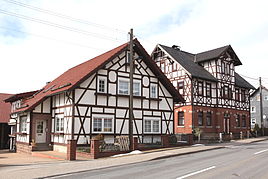
Half-timbered houses in Heckengereuth
|
||
Heckengereuth is a district of the town of Schleusingen in the Hildburghausen district in Thuringia .
location
Heckengereuth is 409 meters above sea level directly at the Ratscher dam . The village is located on the southwestern roof of the Thuringian Forest, southeast of Schleusingen, next to the new federal highway 73 in the hilly terrain of its district .
history
With its 107 inhabitants, the place is the smallest district of Schleusingen. Heckengereuth was first mentioned in a document on June 16, 1354. Until 1815 Heckengereuth belonged to the Henneberg or Electoral Saxon office of Schleusingen and then came to the Schleusingen district of the newly formed Prussian province of Saxony , where it remained until 1945.
The historic Forkelsmühle from 1720 and the home of the blacksmith Kümpel fell victim to the construction of the reservoir from 1975 to 1983. The old town hall, which is under monument protection, was demolished in 2002 and can now be viewed in the Henneberg Museum of Veßra Abbey . 1956 Heckengereuth was incorporated into Ratscher. On February 22, 1994, the community became part of the town of Schleusingen.
Individual evidence
- ↑ www.insuedthueringen.de, January 16, 2014
- ^ Wolfgang Kahl : First mention of Thuringian towns and villages. A manual. Verlag Rockstuhl, Bad Langensalza 2010, ISBN 978-3-86777-202-0 , p. 114

