
Reifnitz (municipality of Maria Wörth)
|
Reifnitz ( village ) locality cadastral community Reifnitz |
|||
|---|---|---|---|
|
|||
| Basic data | |||
| Pole. District , state | Klagenfurt-Land (KL), Carinthia | ||
| Judicial district | Klagenfurt | ||
| Pole. local community | Maria Wörth | ||
| Coordinates | 46 ° 36 '21 " N , 14 ° 10' 53" E | ||
| height | 450 m above sea level A. | ||
| Residents of the village | 821 (January 1, 2020) | ||
| Building status | 288 (2016) | ||
| Area d. KG | 10.89 km² | ||
| Statistical identification | |||
| Locality code | 00908 | ||
| Cadastral parish number | 72158 | ||
| Counting district / district | Maria Wörth (20 419 000) | ||
 Reifnitz Bay with the Pyramidenkogel in the background |
|||
| Source: STAT : index of places ; BEV : GEONAM ; KAGIS | |||


Reifnitz ( Slovene Ribnica ) is a place on the south bank of the Wörthersee in Carinthia . The main town of Maria Wörth has 821 inhabitants (as of January 1, 2020).
Buildings
- Reifnitz Castle ( Slovene Grad Ribnica ob Vrbskem jezeru ), also called "Klein Miramar" ( Slovene Mali Miramar ) castle, was built in 1898 on the headland on the northern edge of the Reifnitz Bay. It presents itself as a fort-like, late historical building on a fortified terrace with a crenellated round tower in the southeast, a stepped gable above the staircase axis on the south facade and a bay window in the northeast. Inside there are, among other things, two coffered ceilings, a ceiling decoration in the Rococo style and in the staircase you can see through remarkable glass windows from the time of construction.
- The Reifnitz castle ruins: The first attempt to build a fortified complex on the castle rock near St. Margarethen-Reifnitz probably dates back to the early medieval Christianization of the pagan Alpine Slavs and the colonization by Bavarian-Franconian new settlers in the 8th / 9th. Century. From this one of the most powerful castles around the Wörthersee arose in the following centuries, which dominated the entire south bank and the Keutschacher Seental. The castle was first mentioned in a document in 1145. It was damaged by the earthquake of 1348 . After several changes of ownership, the Keutschachers are recorded as carers or burgraves of Reifnitz for the end of the 15th century. Today there are only a few remains of the wall and give an idea of the former size and power of this complex. The branch church of St. Margarethen (see below) now stands on the site of the former castle chapel.
- St. Margarethen is a branch church of the parish church St. Georg in Keutschach and is probably the oldest church founded in the Reifnitz-Keutschach area. Probably in 977, but without a doubt when Reifnitz Castle was first mentioned in 1189 or 1195. The Lords of Keutschach, who most likely received financial support from Salzburg Archbishop Leonhard , commissioned a conversion to a late Gothic building core in the High Middle Ages . A keystone in the vault of the nave, where the coat of arms of the Keutschacher, the turnip, is attached, indicates this fact. The Romanesque chapel , of which nothing is left, was located on the highest point of the former castle, where the church is also located. The square on which the late Gothic church stands is delimited on three sides by steep cliffs .
- Beach hotel Sille
- Reifnitz municipal office

"Klein Miramar" castle in 2008
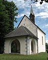
St. Margarethen Church

Beach hotel Sille

Municipal Office


Natural monument
South of Reifnitz in the forest under the castle rock is the so-called sacrifice or witch stone. It is a stone block with a bowl-shaped recess approximately 95 cm in diameter and 15 cm deep with a drainage channel on the upper side and a smooth front face on the east side; it is a pagan place of worship of indefinite date. The stone is a ashlar stone formed by human hands and now overgrown by moss in the forest floor, its dimensions are 3 × 2.4 × 1.4 m. On the top of the place of worship there is a sacrificial bowl 95 cm in diameter and around 15 cm deep. A channel leads from the bowl to the edge of the stone, through which the blood of the sacrificial animals could drain. The hidden location in the single-layered forest should explain this sacrificial stone as a pagan counterpart to the church of Maria Wörth. When Christianity was already being preached there (9th century AD), the inhabitants of this region were still stuck in deep paganism. They met in hidden places for forbidden pagan cult acts and made animal sacrifices to their ancient gods.
Events
Every year in May, automobile enthusiasts meet around the Wörthersee for the "Wörthersee Tour" or "Auto News Wörthersee". Originally the event was called “ GTI-Treffen ”, which is still the more common name.
Web links
- The Reifnitz snake . Legends from Carinthia
Individual evidence
- ↑ Statistics Austria: Population on January 1st, 2020 by locality (area status on January 1st, 2020) , ( CSV )
- ↑ a b Dehio manual. The art monuments of Austria. Carinthia . Verlag Anton Schroll & Co, Vienna 2001, ISBN 3-7031-0712-X , p. 677
- ↑ Christa Hammerl : The earthquake of January 25th, 1348: discussion of sources . In: Review of Historical Seismicity in Europe (RHISE) , 1989–1993, Vol. 2
- ↑ Description on the board on the sacrificial stone