Rieder (Ballenstedt)
|
Rieder
City of Ballenstedt
|
|
|---|---|
| Coordinates: 51 ° 44 ′ 0 ″ N , 11 ° 10 ′ 0 ″ E | |
| Height : | 192 m |
| Area : | 21.41 km² |
| Residents : | 1788 (Dec. 31, 2012) |
| Population density : | 84 inhabitants / km² |
| Incorporation : | December 1st, 2013 |
| Postal code : | 06493 |
| Area code : | 039485 |
|
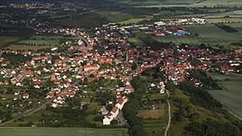
Rieder from the east
|
|
Rieder is a district of the town of Ballenstedt in the Harz district in Saxony-Anhalt (Germany).
geography
In the south, Rieder is bounded by the Kahlenberg. In the north, the Schierberg borders on Rieder. In the middle of the place where the first settlements were built is the Tieberg. The Eulenbach flows through the entire village and later flows into the Wellbach in Gernrode and finally flows into the Bode.
geology
The Kahlenberg is a mountain of Cretaceous rocks, where fossils can still be found. The Schierberg is made of sandstone . There you can also find the “Big Stone” and, furthermore, the “Kutsche” and the “Mohrenkopf”. These are extensions of the devil's wall and terminal moraines.
climate
Rieder lies in the rain shadow area of the Eastern Harz. The annual rainfall is 515 mm. While October is the driest month with a long-term average of 31.3 mm, June is the wettest month with 61.5 mm.
history
The first documentary mention of the place Rieder took place as Rederi in a document from King Otto I of September 13, 936. The settlement area were the sandstone caves of the Klus and Thieberges, where a wooden church and a monastery were built at that time. In the course of time, the new church at the horse pond and the old town hall , which were reconstructed in 1993, were built. Both objects are on the central monument list. The town of Rieder has the second oldest beehive bell in Germany and one of the best-kept church registers, which the writer Otto Gotsche used as the basis for his novel ... and only served anger .
Thanks to favorable geobiological conditions, horticulture came to full bloom as early as the Renaissance. Before the Second World War , Rieder was the largest flower village in Germany. Today the Roseburg is part of the Garden Dreams Saxony-Anhalt project . To the east of Rieder is the Schierberg with the natural monument “Dicker Stein”, a terminal moraine. This ridge belongs to the Teufelsmau massif, which is in front of the Harz Mountains.
From January 1, 1994, the community belonged to the administrative community Gernrode / Harz . The municipality of Rieder was incorporated into the city of Quedlinburg by law with effect from January 1, 2011 and thereby lost its political independence. Until its dissolution it belonged to the administrative community Gernrode / Harz, which had its administrative seat in the city of Gernrode and also ceased to exist on January 1, 2011. A lawsuit against the compulsory incorporation had no suspensive effect, but was decided positively on February 19, 2013 due to a formal error in the hearing and the incorporation was thus initially reversed. On December 1, 2013, Rieder was spun off from the re-established administrative association Gernrode / Harz and incorporated into Ballenstedt.
Memorials and monuments
- Graves in the local cemetery for five unknown concentration camp prisoners who were murdered by SS men on a death march from the Langenstein-Zwieberge concentration camp , a satellite camp of the Buchenwald concentration camp , in April 1945
traffic
Rieder had a train stop on the Quedlinburg – Aschersleben railway line, which was shut down in 2004 by the state of Saxony-Anhalt. Today Rieder is connected to Quedlinburg, Ballenstedt, Thale and Aschersleben by two bus routes operated by the Harz Transport Authority .
politics
coat of arms
The coat of arms was approved on September 3, 1997 by the Magdeburg Regional Council.
Blazon : "Crenellated obliquely, above a silver bell in green, below a black jointed, silver wall."
The colors of the place are green-silver (white).
Rieder did not have an officially approved coat of arms until 1997, but used a community coat of arms designed by himself. This was stylistically revised and adapted to the customs of heraldry. The battlements refer to the Roseburg in Rieder. It is a historic castle from the 11th century. The bell symbolizes the oldest bronze bell in Germany, which was given to a church on the Klus in Rieder in 936 by Mathilde, the widow of King Heinrich I.
The coat of arms was designed by the Magdeburg municipal heraldist Jörg Mantzsch .
flag
The flag is green and white (1: 1) striped with an applied coat of arms.
Religions
The Protestant Christians in Rieder belong to the parish of St. Cyriakus ( Gernrode with the collegiate church of St. Cyriakus and Rieder with the church of Mariae Virginis) in the parish of Ballenstedt of the Evangelical Church of Anhalt .
The Roman Catholic Christians in Rieder belong as part of the community of Gernrode to the Catholic parish of St. Elisabeth in Ballenstedt (communities in Ballenstedt with the church of St. Elisabeth, Gernrode (use of the Protestant collegiate church) and Harzgerode with the church of St. Johannes Baptist ).
Web links
Individual evidence
- ↑ Weather data from DWD.de : data download 1961-1990 , accessed on October 6, 2012.
- ↑ RI II 1, 1 No. 57; Certificate No. 1 in Theodor Sickel (Ed.): Diplomata 12: The documents Konrad I., Heinrich I. and Otto I. (Conradi I., Heinrici I. et Ottonis I. Diplomata). Hannover 1879, p. 89 ( Monumenta Germaniae Historica , digitized version )
- ↑ Law on the reorganization of the municipalities in the state of Saxony-Anhalt concerning the district of Harz.
- ↑ StBA: Area changes from January 1st to December 31st, 2011
- ↑ Ingo Kugenbuch: Three municipalities are independent again after a court ruling . In: Mitteldeutsche Zeitung . Quedlinburg February 20, 2013 ( mz-web.de [accessed February 19, 2013]).
- ↑ StBA: Area changes from January 1st to December 31st, 2013
- ↑ Jörg Mantzsch : The coat of arms of the municipality of Rieder , documentation on the approval process. Filed with the Ministry of the Interior of Saxony-Anhalt 1997 (report: State Main Archive Magdeburg)


