
Rittersbach (Elztal)

Rittersbach has been part of the Elztal municipality since 1975 in the Neckar-Odenwald district .
geography


Rittersbach is located in a wide valley of the Elz , about three kilometers north-east upstream of the Elztal capital, Dallau. The Elz, which runs in a rather narrow valley before and after the town and makes a kink to the west near Rittersbach (defused by the land consolidation of the 1970s), flows north above the town from the east to the Guckenbach , and it also joins the higher altitudes Rittersbach various sources that also drain into the Elz. The abundance of water, especially in spring when the snow melts, repeatedly leads to flooding.
history
The place is a foundation of the Merovingian expansion period, was first mentioned in a deed of gift of September 21, 783 in the Lorsch Codex as Rodinsburon and in Franconian times belonged to the Gau Wingarteiba , over which the diocese of Worms exercised the power of counts. After several other documentary mentions in the 9th century (donations to the Lorsch monastery located in the diocese of Worms ), there was no news about the place until the high Middle Ages. Even without documentary evidence, it is assumed that the place belonged to the Hohenstaufen empire around the Palatinate Wimpfen in the 13th century and came to the Electoral Palatinate after the fall of the Hohenstaufen in the 14th century , which gave the place or parts of it as a fiefdom to various noble families . In 1370, Count Palatine Ruprecht I gave (probably one half of) Rittersbach to a feudal community of Eberhard von Obrigheim as well as Berthold and Wipprecht von Dürn . In 1380/82, the Lords of Heinriet , who had built Dallau Castle in the neighboring village of Dallau and who exercised local rule there before they fell into feuds and became impoverished, sold their Rittersbach rights to Messrs. Münch von Rosenberg . Around 1400 half of the village, the bailiwick and the court were owned by the Pilgrim von Limbach , who ceded their rights to the Rüdt von Bödigheim family in 1403/11. In 1439 the Teutonic Order owned the former half of the village. In 1491, a treaty regulated the formerly fragmented ownership structure in Rittersbach (as in the neighboring towns of Dallau and Auerbach) to the effect that the Teutonic Order and the Electoral Palatinate should each hold half of the rule. This regulation remained in Rittersbach until 1668, when the Teutonic Order exchanged its possessions in the places marked by the Thirty Years War in the Elz Valley with the Electoral Palatinate for a territory near Mergentheim , so that Rittersbach was now entirely part of the Electoral Palatinate. With the reorganization of the German south-west through the Reichsdeputationshauptschluss Rittersbach first came to the Principality of Leiningen in 1802 and, after its rapid decline in 1806, to the Grand Duchy of Baden . Rittersbach was an independent municipality, which on January 1, 1975 joined the Elztal municipality, which was formed from the places Dallau, Auerbach, Neckarburken and Muckental .
Place name
The place name has evolved from its first mention 783 as Rodinsburon over time through Rudwinsburen (835) Rudinspuor (1306), Rudespurre (1400), Rudelspach (1453), Rindenspor (1504), rowing Spur (1549), Ruderspurg (1554 ), Ruderspach (1561) and Ridessbach (1684) until 1714 finally changed to today's Rittersbach . The original place name is interpreted as a designation of the place of residence of a person ("House of Rudwin"). The later changes the name to -sporn , -burg or knight indeed suggest a noble residence, such has not existed in Ritterbach.
Religions
The first mention of a parish church in Rittersbach comes from the year 1306, but there was probably a church in the village long before that. The Rittersbacher Kirchengut goes back to a foundation of Messrs Pilgrim von Limbach from the end of the 14th century (document wrongly dated to 1316). Due to the half affiliation to the Electoral Palatinate was under Elector Friedrich III. around 1560 the Calvinist Reformation also carried out in Rittersbach. The place shares the changeful Reformation history of the Electoral Palatinate, but during the Thirty Years' War it was part of Catholic Bavaria from 1623 to 1648 with a few interruptions, so that at the end of the war all surviving 24 inhabitants were Catholic. After the restitution of the Palatinate conditions after the Peace of Westphalia , the Palatinate and with it the Rittersbacher Church became Calvinist again, but Catholicism remained strong due to the influence of the Teutonic Order. The Teutonic Order exchanged its share in Rittersbach with the Palatinate in 1668, but after Elector Philipp Wilhelm came to power in 1685, there were further attempts at recatholization. In 1698 the Simultaneum was introduced in Rittersbach , so that Catholics and Reformed people could use the church together. In 1705 the numerically much larger Catholic community was finally awarded the old church, which it modernized in 1736/37. The Protestant congregation initially used rooms in the town hall for their church services, built their own prayer room in 1742 and finally the current Protestant church in 1854. From 1886 to 1888, the Catholic community rebuilt today's Catholic Church of St. George .
Attractions


The Catholic Church of St. George was built from 1886 to 1888 on the site of the old church of the village. The church is largely a copy of the Georgskirche in Oberzell on the island of Reichenau in Lake Constance , whereby the reason for the creation of a copy was primarily the paintings of the Oberzell church uncovered in 1880/82, whose restoration was carried out by the head of the Archbishop's Building Office in Mosbach, Ludwig Maier , was involved. Maier's proposal to build a copy of the church in Oberzell, which he admired, was far more favorable than the other considerations previously made in Rittersbach about a new church. The painting was done by the painter Fritz Kohlund from Freiburg. Next to the church is the historic rectory , which was expanded in 1843 and whose barn now serves as the community center.
The Protestant church was built in 1854 according to plans by building inspector Lutz on the state road completed in 1849. It achieved its present form when the roof turret was enlarged in 1909.
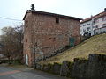
The place has numerous historical buildings from the 17th and early 18th centuries, most of which were erected as half-timbered buildings on stone plinths made of the red sandstone characteristic of the Odenwald. One of the most ornate half-timbered buildings is Haus Weber in Georgstrasse near the Catholic Church, which is considered an example of a farmhouse from the early 18th century.
The town's schoolhouse was built in 1910 as a two-story sandstone building based on plans by Philipp Fleischmann . The neighboring building, in which there is currently a Volksbank branch, is the previous school building from 1866, which was a teacher's residence after 1910, then a training school of the joint advanced training school association of Rittersbach, Auerbach and Muckental. The barn on the neighboring Heinrich property was a residential building and Catholic school in the 19th century. Various other buildings in the village, including the old town hall, Haus Luttenbach and Haus Kniel , have also served as a school building in the past.
The Rittersbacher Mühle on the northern outskirts in the Elztal was first mentioned in a document in 1561, and the mill operated there until 1962. The mill had a concession for a grinding and peeling pass, later also an additional oil mill, and was not a ban mill , so that it was built in the late 18th and 19th centuries in constant competition with 1769, just a little over a kilometer Heidersbacher Mühle upstream of the Elz was located .
The old brewery and schnapps distillery building of the Gasthaus Zum Ritter is also one of the striking structures in the town . The stone building, erected in 1869, marks the orientation of the local tradesmen from the valley to the state road built around 1850 (today's B 27 ), which bypasses the old town center on a ridge to the west. The inn had moved from the center of the village to the new state road in 1850, expanded in 1868 and in 1869 received the concession required for the brewery and distillery.
There are also various small monuments such as fountains, wayside shrines and stone crosses, as well as various historical signposts and landmarks .

Evang. church

House Weber
Ritter Brewery Building
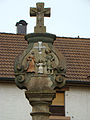
Holy Family Pillar


economy
The largest local employer is OWR GmbH , a manufacturer of devices and systems for NBC protection , with around 85 employees. Otherwise, the place, which is still strongly agricultural today, is primarily a place of residence for commuters to the surrounding towns.
traffic
The town's most important traffic artery is the B 27 , which, coming from Buchen , crosses the town from northeast to southwest and joins the B 292 southwest of Rittersbach . The next railway stops are in the neighboring towns of Auerbach and Oberschefflenz , where the RheinNeckar S-Bahn runs on the Neckarelz – Osterburken line .
literature
- Karl Wilhelm Beichert and Werner Blesch: Rittersbach - A walk through the village and its history , Neckarburken 1993
Web links
- LEO-BW, discover regional studies online , Rittersbach
Individual evidence
- ↑ Minst, Karl Josef [transl.]: Lorscher Codex (Volume 4), Certificate 2849 September 21, 783 - Reg. 1838. In: Heidelberger historical stocks - digital. Heidelberg University Library, p. 246 , accessed on April 13, 2015 .
- ^ Federal Statistical Office (ed.): Historical municipality directory for the Federal Republic of Germany. Name, border and key number changes in municipalities, counties and administrative districts from May 27, 1970 to December 31, 1982 . W. Kohlhammer, Stuttgart / Mainz 1983, ISBN 3-17-003263-1 , p. 485 .

Coordinates: 49 ° 25 ' N , 9 ° 14' E