
Roßberg (Swabian Alb)
| Rossberg | ||
|---|---|---|
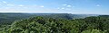
 Roßberg seen from the north, Gönningen in the foreground |
||
| height | 869.6 m above sea level NHN | |
| location | Baden-Wuerttemberg , Germany | |
| Mountains | Swabian Alb | |
| Coordinates | 48 ° 25 '4 " N , 9 ° 8' 34" E | |
|
||
| rock | White Jura | |
| particularities |
|
|

The Roßberg is 869.6 m above sea level. NHN high mountain on the Albtrauf , the western edge of the Swabian Alb , in the area of the Middle Kuppenalb . It is located on a peninsula-like plateau, the so-called Roßfeld , which is only connected in the southeast with the rest of the plateau of the Swabian Alb and is bordered in the north by the Wiesaz valley and in the south by the valley of the Öschenbach. The summit of the Roßberg, formed from Upper Jurassic rock, rises around 100 meters above the plateau. The Kleine Roßberg closes a little to the west at 826.5 m above sea level. NHN height. This consists of tuff and is part of the Swabian volcano .
The closest places are Öschingen (Mössingen) in the west and Gönningen (Reutlingen), which includes the mountain, in the northeast, both of which are below the Alb eaves , and in the east on the Genkingen Alb plateau . From Genkingen a five kilometer long road leads to the Roßberg up to the summit, where there is the Roßberg Tower , a lookout tower of the Swabian Alb Association , and a hiking home. For this reason, the Roßberg is a popular excursion destination, including the Swabian Alb North Rim Trail .
Roßberg Tower and Roßberghaus
The Roßbergtum is the 28 m high observation tower on the Roßberg. At its top, the cast concrete tower carries an antenna mast for the BOS radio . A hiking home is integrated into the tower. On each floor of the tower there are one or more rooms with simple overnight accommodation. An inn is housed in the lower part of the tower.
The tower and hiking home were built by the Swabian Alb Association in 1913 for the 25th anniversary of the Swabian Alb Association, when the hilltop was even less wooded. Originally the entire hiking home was located in the tower, in the 1930s and 1960s the facility was expanded with additions and renovated again in 1982. The street called Roßbergsteige up to the tower was laid out in 1934.
From the top of the tower you can see the Swabian Alb and its foreland. In the west the view extends to the Black Forest , in the north to the Schönbuch and the Stuttgart television tower . In the northeast, the Hohenstaufen and the Hohenneuffen ruins can be seen on the Albtrauf . When visibility is good, the peaks of the northern Alps can be seen to the south .

Roßberg tower and hiking home

On the Roßberg tower

Alpine panorama, taken from the Roßbergturm on January 14, 2006


Quenstedt memorial
On the western side of the hiking home there is an obelisk at a vantage point , reminiscent of Friedrich August von Quenstedt . The geologist, paleontologist and local researcher was a professor in Tübingen and did pioneering work in the geological exploration of the Swabian Alb; the memorial was inaugurated on July 9, 1893, just four years after his death.

Quenstedt memorial
Panoramic view from the Quenstedt monument

literature
- Paul Ackermann: The Roßberg and the Swabian hiking movement: on the history of the highest Reutlingen summit and Gönninger landmark . In: Wilhelm Borth (Ed.): Contributions to the history of Reutlingen and the region: Festschrift for Heinz Alfred Gemeinhardt , Reutlinger Geschichtsverein, Reutlingen 2012, pp. 15-29, ISBN 978-3-939775-32-4 .