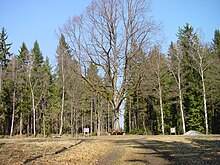
Rondell (Kaiserhammer)
The Rondell is a densely wooded ridge ( 561.9 m above sea level ) near Kaiserhammer, east of Marktleuthen .
history
On this ridge, a free space from which eight paths run into the forest in a star shape at 45-degree angles, Margrave Friedrich wanted to build a hunting lodge for parforce hunting . The construction was stopped in the second half of the 18th century due to lack of money.
As an alternative to the historical explanation, there is the version about a noticeable peculiarity of the rondel at Kaiserhammer. If you look at this spider road on a map, you have to realize that the eight paths are not oriented towards the cardinal points.
Karl Bedal's theory
The spider road has exactly the same direction as some absolutely straight lines, which can be drawn on the map, for example, from Vohenstrauss in the Upper Palatinate to Gattendorf near Hof an der Saale or from there to Scheßlitz near Bamberg , once parallel, another time in offset at right angles. Striking land monuments are always lined up on these lines at a distance of 6.75, 13.5 or 27 kilometers . This suggests that the spider road existed before the planning of the hunting lodge by architect Carl von Gontard . The local history researcher Karl Bedal developed a theory that is criticized as speculative and mystifying, especially since there is no compelling internal connection, even in time, between the objects.
Similar to the Three Crosses at Vohenstrauß, Karl Bedal also allows other striking points to be measured at distances of 6.75 and 13.5 kilometers in addition to the eight-pointed star lines just discussed. From the roundabout it to stone cross at Green spot 6.75 km, the Forest Department Richter's death at the Great Kornberg , 500 meters south of Ranger peace, there are also 6.75 kilometers, the former castle of Bernstein southeast 6.75 km and the village of Kingdom of Heaven, from Asch , 13.5 kilometers. If you draw a line from the roundabout to the Hirschstein, where the Hirschstein Castle of the Hirschberger was built on top of the granite towers, you can see that the distance is again exactly 6.75 kilometers.
If you extend this line by another 6.75 kilometers after Karl Bedal, you come to the "frog" in Schwarzenbach an der Saale , a stone colossus weighing around 170 tons in the shape of a seated frog, 10 meters long, 5 meters wide and 2 meters is thick. Such “frogs” come in many sizes, they are always integrated into this 6.75 or 13.5 kilometer system. In all of these cases there is a link with a limit . One comes closer to the solution if one looks further south, near Tirschenreuth , the so-called Frais or Fraisch. The word Fraisch denotes a jurisdiction. Such “frogs” are undoubtedly Fraischsteine , which marked a court border.
literature
- Karl Bedal : mysterious, sunken, forgotten, invisible, but precisely measured. Strange relationships and connections between stone crosses, cross stones, palaces, castles, churches and paths in northeast Bavaria . Frankenpost Verlag, Hof 1986.
Web links
Individual evidence
Coordinates: 50 ° 8 ′ 0.1 ″ N , 12 ° 3 ′ 56.1 ″ E
