
Rosenthal (Zittau)
|
Rosenthal
City of Zittau
Coordinates: 50 ° 57 ′ 18 ″ N , 14 ° 53 ′ 35 ″ E
|
|
|---|---|
| Height : | 257 m |
| Incorporation : | July 1, 1950 |
| Incorporated into: | Hirschfelde |
| Postal code : | 02788 |
| Area code : | 035843 |
 Location of Rosenthal in the area of the city of Zittau
|
|
Rosenthal is a village in the Saxon Upper Lusatia in the district of Görlitz on the border with Poland . Until it was incorporated into Hirschfelde in 1950, Rosenthal was an independent municipality.
Position and extent
The place is on the left bank of the Lusatian Neisse on the edge of the Neisse breakthrough valley . In the west, the monastery forest of the St. Marienthal monastery borders the village, in the east the Bachaue of the Kemmlitzbach , which also flows through the village. In the north, the area rises to a small plateau that was used by the farmers as arable land. A distinction is therefore made between Oberdorf and Unterdorf. In the south the place joins Hirschfelde.
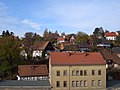
Rosenthal October 2006

In the background the properties in a picturesque location

The upper village of Rosenthal from a Dittelsdorf perspective

The Ziehberg


history


Rosenthal is first mentioned in a document in 1368 under the name Rosental . From its original development it is one of the square villages , there was also a separation between a rural section in the upper village and a part of the houses in the lower village. In the 15th century, Rosenthal became a knight's seat and a Vorwerk was built . In 1595 the landlord Wilrich von Kyaw sold the village for 2000 thalers to the council of the city of Zittau.
After the end of the Thirty Years War in 1648, the place was completely devastated and uninhabited. A short time later settled the town of Zittau here but religious refugees from Bohemia and Moravia , which takes as Leineweber the linen trade should promote the city. In order to promote the reconstruction of the village, the residents were exempted from all taxes for a few years. Rosenthal, which was originally parish to Burkersdorf , was assigned to the Hirschfelde parish from 1570 after the local Johanniterkommende was dissolved.
Until 1771 there was no school in town. The children who were able to attend school at the time were educated either in Hirschfelde or in Rohnau . As a result of the general school regulations in Saxon countries from 1770, a school owner named Johann Christoph Straupe was hired for the first time in Rosenthal on April 26, 1771 , who continued his trade as a linen weaver during the time of administration. When Saxony's first machine flax spinning mill began to produce in Hirschfelde in 1847 , home weaving declined, but many workers from the factory settled here instead.
On July 1, 1950, Rosenthal became part of the Hirschfelde community, which in turn was incorporated into the city of Zittau on January 1, 2007 . The last mayor was Fritz Rokohl.
traffic
The main road from Zittau to Görlitz has led through the town on the steepest road in the wider area, the Rosenthaler Berg. The mill, which is adjacent to the Niederdorf and belonging to Hirschfelder, provided pre-tensioning services for the wagons until the change at Kretscham in Oberdorf. The street today bears the name Ziehberg based on the past times . In 1843 the situation changed with the construction of a bypass road through the Kemlitztal.
After the commissioning of the Zittau – Nikrisch railway line on October 15, 1875, the Rosenthal stop was served for the first time in the area of the Neisse loop between the railway bridges when the summer timetable came into effect on May 15, 1877. This was of tourist importance for day trippers who explored the Neißetal from Görlitz or Zittau. For the residents of Rosenthal or the neighboring Hirschfelde, however, the Rohnau stop was easier to reach. In connection with the Rosenthal stop , the Neißethal inn built by the Niederoderwitz restaurateur Benjamin Anders opened at the same time . In 1882 the Görlitz innkeeper Georg Demnich bought the restaurant, in 1895 Louis Frenzel became the owner. In 1911 the location was named Restaurant zum Neißetal . The owner became the innkeeper Otto Raspe (1870–1920). The inn was continued by his widow Emma Raspe (1872–1945), her daughter and son-in-law until it closed in 1941 and then sold to the Hirschfelde flax spinning mill. After 1945 the building served as a border station and from 1958 as a residential building for five families. The dilapidated building was demolished in 1993. Today there is a rest area with a shelter for cycle tourists at this location.
The Rosenthal stop is no longer served with the timetable change on November 1, 1943.
Population development
| year | Residents |
|---|---|
| 1772 | 220 |
| 1834 | 396 |
| 1855 | 535 |
| 1871 | 627 |
| 1890 | 519 |
| 1910 | 456 |
| 1925 | 467 |
| 1939 | 429 |
| 1946 | 658 |
In 1777, eight possessed men , five gardeners and 28 cottagers ran in Rosenthal .
The first population survey in Saxony, in which not the ownership structure, but each individual inhabitant was counted equally, took place in 1834, at that time almost 400 people lived in the village. The population increased within half a century to 627 inhabitants in 1890. The reason for this was the establishment of the Hirschfelde HC Müller flax spinning mill and the associated settlement of factory workers. Later the population fell again. After the end of the Second World War , many refugees found a new home in Rosenthal, so that the population grew to over 650 residents.
Place name forms
Forms of place names for Rosenthal include Rosental (1368), Rosinthal (1429), Rosen Thal (1648), Rosenthal (1791) and Rosenthal b. Zittau (1875). Today the Rosenthal form is used again .
literature
- The south-eastern Upper Lusatia with Zittau and the Zittau Mountains (= values of the German homeland . Volume 16). 1st edition. Akademie Verlag, Berlin 1970, pp. 93-94.
- Hermann Knothe : History of the villages Rohnau, Rosenthal and Scharre, near Hirschfelde in the Koenig. Saxon Upper Lusatia . Zittau 1857 (Reprint: Ostritz 2003). ( Digitized original edition )
- Rosenthal lists of residents from 1902
Web links
- Information about Rosenthal on the homepage of the former municipality of Hirschfelde
- Homepage about Rosenthal near Hirschfelde
Individual evidence
- ↑ Municipalities 1994 and their changes since January 1, 1948 in the new federal states , Metzler-Poeschel publishing house, Stuttgart, 1995, ISBN 3-8246-0321-7 , publisher: Federal Statistical Office
- ^ Area changes from January 1, 2007 to December 31, 2007. (PDF; 13 kB) State Statistical Office of the Free State of Saxony , p. 1 , accessed on January 5, 2013 .
- ↑ Rosenthal in the Digital Historical Directory of Saxony
- ↑ CFT Rudowsky: directory of whole villages of the Kingdom of Saxony ... after counting on 3 December 1855. Ramming, Dresden 1857 S. 63rd