
Rotgundspitze
| Rotgundspitze | ||
|---|---|---|
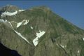
 Rotgundspitze and Linkerskopf from Heilbronner Weg |
||
| height | 2485 m | |
| location | Border Bavaria , Germany / Tyrol , Austria | |
| Mountains | Central main ridge , Allgäu Alps | |
| Dominance | 0.7 km → Wilder Mann | |
| Notch height | 135 m ↓ notch to the Wilder Mann | |
| Coordinates | 47 ° 17 '17 " N , 10 ° 15' 57" E | |
|
||
| rock | Main dolomite | |
| First ascent | by locals | |

The Rotgundspitze is a 2485 m high mountain in the main ridge of the Allgäu Alps . It lies south-south-east of the Linkerskopf and, together with the south-west Hochgundspitze , forms the Great Steinscharte .
There is no marked path to the Rotgundspitze. It can be reached without a path from the Wiesleskar via Schrofengelände and requires surefootedness and a head for heights .
literature
- Richard Goedeke : In Bergkamerad , Dec. 1964
- Thaddäus Steiner : Allgäuer Bergnames , Lindenberg, Kunstverlag Josef Fink, 2007, ISBN 978-3-89870-389-5
- Thaddäus Steiner: The field names of the municipality of Oberstdorf im Allgäu , Munich, self-published by the Association for Field Name Research in Bavaria, 1972
- Zettler / Groth: Alpine Club Guide Allgäu Alps . Bergverlag Rudolf Rother , Munich 1984. ISBN 3763311114
Web links
Commons : Rotgundspitze - collection of images, videos and audio files
photos

Hochgundspitze, Große Steinscharte and Rotgundspitze

Linkerskopf and Rotgundspitze from the Kleiner Rappenkopf , below the Rappenseehütte
Rotgundspitze and Linkerskopf from the Waltenberger house

Bacherloch , Rotgundspitze and Linkerskopf from Einödsberg


