Ruta 11 (Uruguay)
| Ruta 11 in Uruguay | ||||||||||||||||
| José Batlle y Ordóñez | ||||||||||||||||

|
||||||||||||||||
| map | ||||||||||||||||
| Basic data | ||||||||||||||||
| Operator: |
Ministerio de Transporte y Obras Públicas |
|||||||||||||||
|
Course of the road
|
||||||||||||||||
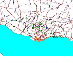
The Ruta 11 José Batlle y Ordóñez is a national road in Uruguay .
The 167-kilometer road is located in the south of the country and leads from the coast west of Montevideo to the coast of the Rio de la Plata east of the capital through the departments of San José and Canelones . It runs from the city of Ecilda Paullier , where it branches off from Ruta 1 , through the cities of San José de Mayo , Santa Lucía and Canelones . The Ruta 11 finally ends in Atlántida , where it meets the Ruta Interbalnearia (IB).
The street was named in 1983 after the Uruguayan journalist and politician José Batlle y Ordóñez, who died in 1929 .
Web links
Commons : Route 11, Uruguay - collection of images, videos and audio files
Individual evidence
- ↑ Ley No 15.497 - Rutas Nacionales ( page no longer available , search in web archives ) Info: The link was automatically marked as defective. Please check the link according to the instructions and then remove this notice. ( spanish )

Junction of Ruta 11 (from below) with Ruta 7 (from left) in San Jacinto
