
Sériers
| Sériers | ||
|---|---|---|
|
||
| local community | Neuvéglise-sur-Truyère | |
| region | Auvergne-Rhône-Alpes | |
| Department | Cantal | |
| Arrondissement | Saint-Flour | |
| Coordinates | 44 ° 59 ′ N , 3 ° 2 ′ E | |
| Post Code | 15100 | |
| Former INSEE code | 15227 | |
| Incorporation | 2017-01-01 | |
| status | Commune déléguée | |
 former Mairie Sériers |
||

Sériers is a village at 1,000 meters above sea level in the French department of Cantal in the region of Auvergne Rhône-Alpes . The municipality , which existed until January 1, 2017, belonged to the canton of Saint-Flour-2 and the Arrondissement of Saint-Flour . By a decree of September 21, 2016, it merged with Lavastrie , Neuvéglise and Oradour in the Commune nouvelle Neuvéglise-sur-Truyère . Since then it has been a Commune déléguée .
Neighboring towns are Les Ternes in the northwest, Villedieu in the northeast, Alleuze in the southeast, Lavastrie in the south and Neuvéglise in the west.
Population development
| year | 1962 | 1968 | 1975 | 1982 | 1990 | 1999 | 2004 | 2009 | 2014 |
|---|---|---|---|---|---|---|---|---|---|
| Residents | 204 | 193 | 186 | 165 | 172 | 148 | 140 | 133 | 136 |
Attractions
- Dolmen de la Table au Loup, Monument historique from 1911
- Menhir of Christianization , Monument historique from 1911
- Menhir Bargueyrac or Pierre Plantade, Monument historique from 1911
- Saint-Jacques church
- Hall cross at the church
- War memorial

Dolmen de la Table au Loup

Menhir of Christianization
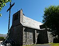
Saint-Jacques church and hall cross

Menhir Bargueyrac
.jpg)


Web links
Commons : Sériers - collection of images, videos and audio files