
Săliştea de Sus
|
Săliştea de Sus Felsőszelistye |
|||||
|
|||||
| Basic data | |||||
|---|---|---|---|---|---|
| State : |
|
||||
| Historical region : | Maramures | ||||
| Circle : | Maramureș | ||||
| Coordinates : | 47 ° 39 ' N , 24 ° 21' E | ||||
| Time zone : | EET ( UTC +2) | ||||
| Area : | 64.77 km² | ||||
| Residents : | 4,893 (October 20, 2011) | ||||
| Population density : | 76 inhabitants per km² | ||||
| Postal code : | 437295 | ||||
| Telephone code : | (+40) 02 62 | ||||
| License plate : | MM | ||||
| Structure and administration (as of 2016) | |||||
| Community type : | city | ||||
| Mayor : | Ștefan Iuga ( PSD ) | ||||
| Postal address : | Str. Principală, no. 981 loc. Săliştea de Sus, jud. Maramureș RO-437295 |
||||
| Website : | |||||


Săliştea de Sus ( Hungarian Felsőszelistye ) is a small town in Maramureş County in Romania .
location
Săliştea de Sus is located 50 km southeast of Sighetu Marmației and 25 km west of Borşa , on highway 186 in the valley of the river Iza .
history
Săliştea de Sus was first mentioned in 1365. In 2004 the village was elevated to a city.
population
At the last census in 2002 there were 5,196 inhabitants in Săliştea de Sus; 5185 of them were Romanians , three Hungarians , seven Roma and one Ukrainian . In the last few decades the population has declined somewhat; In 1992, most of the inhabitants were registered with 5814.
traffic
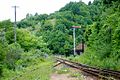
The national road 186 runs through Săliştea de Sus. In the east of the city is the "Iza" train station on the Salva – Vișeu de Jos railway line .
Attractions
- Wooden church “St. Nikolaus ”( a Nistoreştilor church or“ mountain church ”) from 1680. After a fire by the Tatars in 1717, it was rebuilt. The church is a listed building.
- Wooden church “St. Nikolaus ”( a Bulenilor Church or“ Church of the Valley ”) from 1736. On the inner walls there are original paintings and symbols from the 18th century and is a listed building.

Eastern entrance to the village

Viaduct, in front of the eastern entrance to the village

Viaduct at the eastern entrance to the village

Tower at the entrance to the village

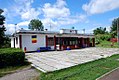
A school for grades 1-8


In the center is the school for grades 1–8

Church in the center on the state road

Entrance door of the church

Through town

Police station. Opposite a small sign "Monument" indicates the Bulenilor Church

Old wooden house

Old wooden house, on the left behind the Bulenilor Church

Wooden Church of St. Nicholas (also Bulenilor Church or Church of the Valley)

Wooden gate to the Bulenilor church

Entrance door to the Bulenilor Church

Sign on the Bulenilor Church

Church bells of the Bulenilor Church

This church is located at a distance of 50 meters from the Bulenilor church

Entrance to the church
The IZA station on the Salva – Vişeu de Jos railway line

Wood stove in the waiting room

Ticket office
Exit signal in north direction

View over the platform to the east

View over the track field to the east

View from the east towards the train station. On the right the entry signal


Web links
Individual evidence
- ↑ 2011 census in Romania at citypopulation.de
- ↑ Information on the city's website , accessed on February 20, 2014
- ↑ Árpád E. Varga: Máramaros megye településeinek etnikai (anyanyelvi / nemzetiségi) adatai 1850 / 1880–2002. (Online document) (PDF file; 650 KB).
- ↑ a b List of historical monuments of the Romanian Ministry of Culture, updated 2010 (PDF; 7.10 MB)

Baia Mare | Baia Sprie | Borșa | Cavnic | Dragomireşti | Săliştea de Sus | Seini | Sighetu Marmației | Șomcuta Mare | Târgu Lăpuș | Tăuții-Măgherăuș | Ulmeni | Vişeu de Sus