
Târgu Lăpuș
|
Târgu Lăpuș Hungarian-Laposch Magyarlápos |
|||||
|
|||||
| Basic data | |||||
|---|---|---|---|---|---|
| State : |
|
||||
| Historical region : | Transylvania | ||||
| Circle : | Maramureș | ||||
| Coordinates : | 47 ° 27 ' N , 23 ° 52' E | ||||
| Time zone : | EET ( UTC +2) | ||||
| Height : | 334 m | ||||
| Area : | 247.35 km² | ||||
| Residents : | 11,744 (October 20, 2011) | ||||
| Population density : | 47 inhabitants per km² | ||||
| Postal code : | 435600 | ||||
| Telephone code : | (+40) 02 62 | ||||
| License plate : | MM | ||||
| Structure and administration (as of 2016) | |||||
| Community type : | city | ||||
| Structure : | 13 Districts / cadastral municipalities: Boiereni , Borcut , Cufoaia , Dămăcușeni , Dobricu Lăpușului , Dumbrava , Fântânele , Groape , Inău , Răzoare , Rogoz , Rohia , Stoiceni | ||||
| Mayor : | Mitru Leșe ( PNL ) | ||||
| Postal address : | Țibeșului street, no. 2 loc. Târgu Lăpuș, jud. Maramureș, RO-435600 |
||||
| Website : | |||||


Târgu Lăpuş [ ˈtɨrgu ləpuʃ ] (until 1920 Lăpuşu Unguresc ; until 1993 Tîrgu Lăpuş ; German Hungarian Laposch , Hungarian Magyarlápos ) is a city in the Maramureş district in Romania .
The place is also known under the German name Eberfeld .
location
Târgu Lăpuș is located in northern Transylvania on the Lăpuș River . The district capital Baia Mare is located about 30 km northwest.
history
In 1291 the place - which then belonged to the Kingdom of Hungary - was first mentioned under the name Lapus . It developed into the economic center of the Laposcher country ( Țara Lăpușului ). Târgu Lăpuș was predominantly shaped by Hungarians , while the villages in the area that are now partially incorporated (exception: Dămăcuseni / Domokos) lived almost exclusively Romanians . In contrast to many other regions of Transylvania, Transylvanian Saxons hardly played a role here. In 1968 Târgu Lăpuș was declared a city. Today agriculture, forestry and wood processing are the most important branches of the economy.
population
In 1850, 7884 people lived in the area of today's city, 1529 of them in Târgu Lăpuș and 6355 in the places that are now incorporated. 5745 of these described themselves as Romanians, 1700 as Hungarians , 262 as Jews and 105 as Roma . As a result, the proportion of Romanians increased, while that of Hungarians decreased. In the 2002 census, 13,355 inhabitants were registered, of which 5844 in Târgu Lăpuș and 7511 in the incorporated villages. 11,548 were Romanians, 1659 Hungarians and 140 Roma.
The 2011 documentary "Our School" by Mona Nicoară and Miruna Coca-Cozma deals with efforts to overcome the school exclusion of Roma children in Târgu Lăpuș.
traffic
Târgu Lăpuș has no rail connection. The city lies on Drum național 18B, which is not yet fully developed . There are regular bus connections to Baia Mare.
Attractions
- The wooden church Sf. Arhangheli in the district of Rogoz (built in 1663 in Suciu de Sus ), was erected here in 1883; is a UNESCO World Heritage Site .
- Sfânta Ana Monastery in the Rohia district (1926)
- Roman Catholic Church (1752)
- Cheile Lăpușului valley gorge
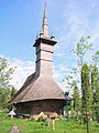
Wooden church in Rogoz

Church in Fântânele

Wooden church in Groape

Wooden church in Dumbrava

Wooden church in Stoiceni
.JPG)


.JPG)

Web links
Individual evidence
- ↑ 2011 census in Romania at citypopulation.de
- ↑ Heinz Heltmann, Gustav Servatius (Ed.): Travel Guide Siebenbürgen. Kraft-Verlag, Würzburg 1993, ISBN 3-8083-2019-2 .
- ^ Carl Göllner (Red.): History of the Germans on the territory of Romania. Kriterion Verlag, Bucharest 1979, p. 449.
- ↑ Website of the city, accessed on December 30, 2008 ( Memento of the original from December 9, 2008 in the Internet Archive ) Info: The archive link was inserted automatically and has not yet been checked. Please check the original and archive link according to the instructions and then remove this notice.
- ↑ 2002 census, accessed December 30, 2008 (PDF file; 650 kB)
- ↑ IndieWIRE; April 12, 2011: “Our School” Directors Mona Nicoara and Miruna Coca-Cozma
- ↑ Information on the wooden church in Rogoz from unesco.org accessed on February 21, 2014 (English)

Baia Mare | Baia Sprie | Borșa | Cavnic | Dragomireşti | Săliştea de Sus | Seini | Sighetu Marmației | Șomcuta Mare | Târgu Lăpuș | Tăuții-Măgherăuș | Ulmeni | Vişeu de Sus