Salda (tura)
|
Salda Салда́ |
||
|
|
||
| Data | ||
| Water code | RU : 14010501212111200004770 | |
| location | Sverdlovsk Oblast ( Russia ) | |
| River system | If | |
| Drain over | Tura → Tobol → Irtysh → Ob → Arctic Ocean | |
| source |
Central Urals 58 ° 17 ′ 29 ″ N , 59 ° 51 ′ 14 ″ E |
|
| Source height | approx. 250 m | |
| muzzle |
Tura coordinates: 58 ° 47 '28 " N , 61 ° 20' 52" E 58 ° 47 '28 " N , 61 ° 20' 52" E |
|
| Mouth height | 81 m | |
| Height difference | approx. 169 m | |
| Bottom slope | approx. 0.93 ‰ | |
| length | 182 km | |
| Catchment area | 3670 km² | |
| Discharge at the Prokopjewskaja Salda A Eo gauge : 3120 km² Location: 36 km above the mouth |
NNQ (March 1969) MNQ 1937/1986 MQ 1937/1986 Mq 1937/1986 MHQ 1937/1986 HHQ (April 1973) |
230 l / s 1.1 m³ / s 13.4 m³ / s 4.3 l / (s km²) 43.6 m³ / s 113 m³ / s |
| Medium-sized cities | Kushwa , Krasnouralsk | |
|
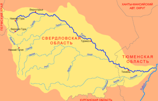
Location of the Salda (Салда́) in the Tura catchment area |
||
The Salda ( Russian Салда́ ) is a 182 km long right tributary of the Tura in Siberia ( Russia , Asia ). It is not to be confused with the tributary of the same name, the Salda des Tagil, which flows a little south .
course
The Salda has its source in about 250 m on the east side of the Blagodat mountain , an important iron ore deposit in the Middle Urals , immediately east of the city of Kuschwa . Soon the river flows around the city of Krasnouralsk a few kilometers southeast, near the district of Oktyabrsky, then in northeastern directions the Ural hinterland always on the territory of the Sverdlovsk Oblast . The area through which it flows is sparsely populated, wooded and partly swampy. In the middle reaches, the river has cut its way steeply more than 50 meters deep into the surrounding plain. Only on the lower reaches are several villages again. Finally, the Salda flows into the Tura near the village of Ust-Salda about 30 kilometers east of Verkhoturye (at 81 m above sea level). Near the mouth, the Salda is almost 50 meters wide, one meter deep and the flow velocity is 0.5 m / s.
Hydrography
The catchment area of the Salda covers 3670 km². It has no major tributaries.
The Salda freezes between October to early November and late April to May. The mean monthly water flow is 36 river kilometers above the estuary 11.5 m³ / s.
Infrastructure and economy
The Salda is not navigable. In the upper reaches near Kuschwa and Krasnouralsk, several small reservoirs were created for mining purposes (iron and copper mining).
Except in the vicinity of the source and mouth, the infrastructural area of the river is hardly developed due to the sparse settlement. A road bridge crosses the river near the mouth.
Individual evidence
- ↑ a b Article Salda in the Great Soviet Encyclopedia (BSE) , 3rd edition 1969–1978 (Russian)
- ↑ a b Salda in the State Water Register of the Russian Federation (Russian)
- ↑ Salda at the Prokopjewskaja Salda gauge - hydrographic data from R-ArcticNET
