Tagil
The Tagil ( Russian Таги́л , mansian for "lots of water") is a 414 km long right tributary of the Tura in Siberia ( Russia , Asia ).
course
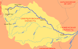
The Tagil rises on the eastern slope of the Urals in the southwestern Sverdlovsk Oblast , about 50 km northwest of the regional capital Yekaterinburg . From there it flows in a northerly direction through a wooded low mountain range. After a few kilometers it reaches Verkhny Tagil , where he km² to 2.6 large Werchnetagilskoje wodochranilischtsche ( Russian Верхнетагильское Водохранилище even Верхнетагильский пруд ( Werchnetagilski Prud , Werchnetagilsker Pond)) is dammed serving the fishing industry.
Thereafter, the Targil continues to flow in a northerly direction, where it soon reaches the industrial city of Nizhny Tagil , the largest city on its course. Here, too, it is dammed to a reservoir, the 9.84 square kilometer Nischnetagilskoje wodochranilischtsche ( Russian водохранилище Нижнетагильское even Нижнетагильский Пруд ( Nischnetagilski Prud , Nischnetagilsker Pond)). This is used for domestic water supply , based in Nizhny Tagil Montan , defense and chemical industries , including the steel producer NTMK ( Russian Нижнетагильский металлургический комбинат ( Nischnetagilski metallurgitscheski kombinat )) and the machine manufacturer and the world's largest tank manufacturer Uralvagonzavod ( Russian Уралвагонзавод ).
After flowing through Nizhny Tagil, the Tagil initially turns to the northwest and enters the West Siberian lowlands from the Urals . After the confluence of the Barantscha , it turns to the east and northeast, where it flows in wide curves through the wooded west of the Sverdlovsk Oblast. A little later, shortly before the mouth of the Mugai , the forest recedes further from the river and the banks of the Tagil are increasingly used for agriculture. Below Machnewo , the Tagil begins to meander very strongly . In this area he forms numerous oxbow lakes . Shortly afterwards the Tagil reaches the Tura near Bolotowskoje , into which it joins when coming from the right.
Hydrology and use
The Tagil is frozen for an average of 160 days from the beginning of November to the second half of April. The river is fed by mixed rain and snowmelt , with the latter slightly predominating. It has its lowest runoff values in winter, during the thaw in spring the water level rises sharply and can be up to three meters above normal. The highest runoff values are measured in April and May.
In addition to using process water in Nizhny Tagil, the Tagil is also used for fish farming, especially in its upper reaches near Verkhny Tagil. The river is navigable.
Web links
- Tagil ( Memento from April 18, 2013 in the web archive archive.today ) in Brockhaus-Efron - Encyclopedic Dictionary , quoted by Yandex (russ.)
Individual evidence
- ↑ a b c Article Tagil in the Great Soviet Encyclopedia (BSE) , 3rd edition 1969–1978 (Russian)
- ↑ a b c Tagil in the State Water Register of the Russian Federation (Russian)
- ↑ a b Tagil at the Troschkowa gauge - hydrographic data from R-ArcticNET
- ↑ Verkhtagilskoye Vodochranilishche in the State Water Directory of the Russian Federation (russ.)
- ↑ Nizhnetagilskoye Vodochranilishche in the State Water Register of the Russian Federation (Russian)
- ↑ a b Article Тагил in the Great Soviet Encyclopedia (BSE) , 3rd edition 1969–1978 (Russian)

