
Shame
|
Shame
community Moser
|
|
|---|---|
 |
|
| Height : | 59 m above sea level NHN |
| Area : | 11.35 km² |
| Residents : | 1412 (Jan. 1, 2019) |
| Population density : | 124 inhabitants / km² |
| Incorporation : | January 1, 2010 |
| Postal code : | 39291 |
| Area code : | 03921 |
Schermen is a village in the municipality of Möser in the Jerichower Land district in Saxony-Anhalt .
geography
The district is located in the southwest of the Jerichower Land district on the western edge of the Hoher Fläming ridge . The built-up settlement core is about 0.8 km² and lies at an altitude of 65 to 48 meters, sloping to the northwest. Schermen is nestled between the Külzau Forest in the west and the Wulffenschen Forest in the east. To the north-east of the village there is a two km² wetland of the Beeke source area. Two kilometers to the southeast rise the 105 meter high Kapaunenberg and the 102 meter high Kapaunenberg , which are among the highest peaks in the district. The administrative center of Möser is two kilometers away and the district town of Burg is five kilometers away.
history
The settlement of the place can be proven archaeologically as early as the 3rd and 4th centuries AD. In the 10th century the old Slavic settlement belonged to Burgwardei Biederitz . Already at the beginning of the 14th century there was a church in Schermen, in which a nun was buried in 1316 and a monk in 1318. The first documentary mention of it comes from the year 1397. The manor, which already existed in the 15th century, was initially owned by the Counts of Lindow-Ruppin , fell into the hands of the von Meyendorf family in 1562 and was inherited in 1616 by the von Alvensleben auf Randau family . During the Thirty Years War, the place suffered severe damage. After the secularization of the Archdiocese of Magdeburg , Schermen came under Brandenburg-Prussian rule in 1680 and was initially assigned to the Holzkreis from 1773 to the Ziesarschen Kreis . With the Prussian Administrative Code of 1815 it came to the district Jerichow I . At that time Schermen had 162 inhabitants (1818). Initially located off the old postal road Magdeburg – Burg, the village was connected to the new Magdeburg – Berlin trunk road in 1824. As a result, the number of inhabitants in the town, which had 40 houses, increased to 339 by 1842. A water mill, a large distillery and a brick factory had settled there. In the 1920s, the former manor was settled by the community. Before the outbreak of the Second World War, 1133 people lived in Schermen (1939). With the territorial reform of the GDR in 1952, Schermen was assigned to the Burg district in the Magdeburg district . Until 1964 the population increased only slightly to 1143. Since the German reunification in 1990, Schemen has been in the state of Saxony-Anhalt. In the course of a regional reform, the place was assigned to the newly formed district of Jerichower Land in 1994. Since January 1st, 2010 Schermen is part of the municipality of Möser.
politics
Local council and local mayor
The local council consists of seven members. Marko Simon has been the local mayor since 2012.
badges and flags
The coat of arms designed by the Heraldische Gesellschaft Schwarzer Löwe in Leipzig was approved on March 15, 1995 by the Magdeburg Regional Council. The following blazon was documented in the approval process : “A green mulberry tree with a black trunk growing in silver from a green shield base.” The mulberry tree shown was already on seals from the 18th century and is the landmark of the place (see sights below ).
The local colors are green-silver (white). This color combination also bears the local flag, which the regional council approved on October 12, 2001. It is 1: 1 green and white striped, with the stripes running vertically on the hoist flag and the stripes running horizontally on the cross flag. Both types of flags are covered with the local coat of arms (hoisted flag above the center, cross flag in the middle).
Buildings and sights
- In the eastern center of the village is the late Romanesque Protestant village church Schermen with furnishings from the 16th and 17th centuries.
- To the west of the village is the Bocksmühle , a historic water mill that is now used as a restaurant.
- On the village square stands the more than 250 year old Schermen mulberry tree , the symbol of the place. It is reminiscent of the initiative of the Prussian King Friedrich II , who had mulberry plantations built for silkworm breeding in the 18th century in order to become independent of silk imports. In 1775 there were 111 usable mulberry trees in Schermen.
- In the local cemetery there are gravesites for ten concentration camp prisoners , including a woman who was murdered by SS men on a death march from a concentration camp in April 1945 .
- Schacht Schermen memorial for the ten victims of May 1945
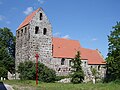
Church from the south

Bock mill
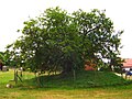
Mulberry tree


Transport links
A former section of federal highway 1 from Magdeburg to Burg runs through Schermen , which, after the construction of a bypass road, connects the town to the federal highway in the south and north. The Burg-Zentrum junction of the A2 motorway is located immediately south of Schermen. The next regional train stations are in Möser and Burg, the long-distance train station Magdeburg is 19 kilometers away. The next port of the Elbe-Havel Canal is in Burg.
Web links
- Information about the village at www.gemeinde-moeser.de
Individual evidence
- ↑ Möser municipality - registration office (ed.): Population figures in the Möser municipality including the individual districts as of 01.01.2019 . January 25, 2019.
- ↑ Main statute of the community of Möser. Möser community, July 1, 2014, accessed on January 24, 2019 .
- ^ Local mayor and local council. In: www.gemeinde-moeser.de. Möser community, accessed on July 11, 2015 .