
Shipping signs


Shipping signs ( also known as sea signs in the coastal area and in the area of maritime waterways ) are audible or visible markings that serve as navigation aids in shipping . Together with the nautical charts in the coastal area and the electronic navigation maps for inland waterways ( IENC ) in the inland area, they enable safe navigation. Typical navigation signs are buoys, beacons and lighthouses .
For Germany , the characters in the international are Collision Regulations , the Seeschifffahrtsstraßen- and in the inland waterways of Procedure , in Switzerland in the inland waterways regulation regulated.
history
The first navigation signs were natural navigation aids such as groups of trees or coastal formations. Artificial signs were added later, which were initially called all beacons (signs) in today's German-speaking countries : piles of stones or wooden scaffolding, fixed or floating, with or without a fire lit at night. In 1225 Waldemar II allowed the establishment of a sea mark on Falsterbo (Hanseatic document book, see Ref.), In 1226 a sea mark is mentioned near Travemünde (Lübisches document book, see Ref.).

_im_Nautineume_Stralsund_(2008-05-11).JPG)
From 1286 Hamburg planned the construction of a tower with a lantern on the island of Neuwerk in the mouth of the Elbe , which not only served as a defense tower to secure the region, but also as a landmark during the day. There are surviving documents that show that floating nautical signs were displayed from the 14th century. The so-called Schartonne in the Outer Elbe is mentioned in 1466. The Hamburg merchants brought them out with a merchant ship .
As a floating sea mark, barrels were usually made of oak with iron rings like a barrel . The various forms of today developed later. Around 1900 there were around 134 tons in the Elbe river.
At first, all the bins were black because, like all wooden beacons, they were preserved with tar and pitch. From 1575 one began to lay out white barrels. In 1887, the Chancellor of the Reich ( Otto von Bismarck ) issued an announcement regarding the uniform designation of the fairways and shoals in German coastal waters, ordering uniform buoys on the German coasts: red spar buoys (slim, rod-shaped) on the starboard side and black, pointed buoys the port side .
Since 1982, the IALA regulation has been in effect internationally for the buoying of sea routes . This includes a globally standardized system of five different types of buoys: lateral , cardinal , central fairway, individual danger points and other buoys . The lateral system is defined in two different forms depending on the region. They arose because the chances of a worldwide agreement on one form were slim.
Green lies:
- in region A (Europe, Australia, New Zealand, Africa and some Asian countries) for incoming vehicles on starboard,
- in Region B (America, Japan, Korea, Philippines), however, to port.
function

Sea markings are used for visual navigation and are often positioned at dangerous spots as well as in rivers and navigable inland lakes to orient the seafarers.
They are clearly distinguishable by their shape and color and partly by light signals ( lighting ) and have internationally defined meanings. Seamarks with radar beacons ( Racon ) identify themselves on a radar screen with special symbols (mostly Morse codes ) that are entered on nautical charts .
Floating marks are lightships and buoys . The term buoy, which is often used in this context, is unusual for sea marks.
In the general teaching of signs ( semiotics ), a nautical mark is a signal .
Types


A distinction is made between floating nautical signs connected to the bottom by means of an anchor chain and fixed, rigidly connected to the bottom. In detail, you can distinguish all sea marks according to their shape and color, often also according to the shape and color of the top marks .
Floating sea mark
- Lightships
- Lateral signs to designate the fairway limits. In Region A of the IALA Lateral System, to which Europe belongs, one uses (seen from the sea, emphasized on the mountain ):
- to port: red, with blunt top marks
- Spar barrels
- Beacon bins
- Butt tons
- to starboard: green, with sharp top marks
- Pointed bins
- Beacon bins
- to port: red, with blunt top marks
- Lateral signs to designate the fairway limits. In region B of the IALA Lateral System , (seen from the lake, buoyed to the valley ) are used:
- to port: green, with blunt top marks
- Spar barrels
- Beacons
- Butt tons
- to starboard: red, with pointed top marks
- Pointed bins
- Beacon bins
- to port: green, with blunt top marks
-
Middle fairway sign , to control entrances or to mark safe fairways:
- Beacon and ball bins
- Designation of danger spots (cardinal system, to warn of shoals, underwater obstacles such as wrecks , groynes and other navigation obstacles)
- Marking bucket - yellow with a cross as a top mark - designates special areas or places
- for mooring
- Mooring buoys
The imaginary line along rows of similar buoys, for example on the edges of the fairway, is called a buoy line.
Fixed navigation marks
- Lighthouses
- Designation of the fairway
- Port
- Starboard
- Beacon, green (with lateral system A) or a pointed top mark, usually a cone
- Pricke (undergrowth wide, above tied up undergrowth), sometimes called fir
- Pole with a black triangle pointing upwards as a top symbol
- Sea mark for the designation of shoals (cardinal system)
Many navigation signs , both floating and fixed, can also be equipped with a periodic or permanent light (see night sea sign ). The color of the light is red or green for lateral signs, otherwise mostly white.
Classification
You can distinguish between day, night, sound and radio signals, for example, with navigation signs according to their perceptibility: day signals are not illuminated, night signals have a lighting system, sound or fog signals can be heard acoustically, and radio signals can be located using radio direction finding . The last two groups are increasingly rare.
According to their positioning, navigation signs can also be divided into fixed (e.g. beacons and lighthouses) and floating ones. In addition to lightships, tons are part of the floating nautical signs. They are firmly anchored to the ground and are now mostly made of steel or plastic.
Visual signals
| Sea mark | function | Appearance | black / solid | Day Night |
|---|---|---|---|---|
| lighthouse | various | Tower or lattice tower | firmly | T + N |
| Lightship | various | Ship, often painted red | floating | T + N |
| Beacon | Visual signals | Tower or scaffolding made of wood or steel | firmly | T |
| pole | Visual signals | Pole or stake with top mark | firmly | T |
| Prick | Fairway designation | Tree branches on poles or young tree | firmly | T + N |
| Lateral sign | Lateral fairway limitation (in the interior: fairway limitation) | red or green bin | floating or fixed | T + N |
| Cardinal characters | Shallow next to the buoy | yellow-black bin | floating or fixed | T + N |
| Middle fairway sign | safe fairway or control | red and white bin | floating or fixed | T + N |
| Single hazard sign | Shallow at buoy location | red-black bin | floating | T + N |
| Emergency wreck buoy | New wreck at the buoy not yet noted in nautical publications | yellow-blue bin | floating | T + N |
| Mooring bucket | Mooring | yellow bin | floating | T (+ N) |
| Cable barrel | Cable route (avoid anchoring) | yellow bin | floating | T (+ N) |
Sound signal

Some visual signs are also equipped with sound signal generators:
- Nebelhorn - Acoustic signal, either on a buoy, on board a lightship or stationary on land, to mark an obstacle
- Howling barrel
- Gong barrel
- Bell barrel - there are only six left in Germany. One of the last (Kieler Förde 6) warns of the shoal near Laboe ( 54 ° 24 ′ 48 ″ N , 10 ° 12 ′ 55 ″ E ) in the Kiel Fjord : When there is a swell, four clappers strike a small bell irregularly.
Lay tons
Tons are laid out with special ships , so-called buoy layers:

The French buoy-ship Gascogne

when laying out
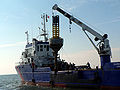
a ton
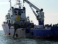
in calm seas


Maintenance of the navigation mark in Germany
The Federal Waterways and Shipping Administration, which currently has 39 Waterways and Shipping Offices (WSA), is responsible for maintaining the navigation marks in German territorial waters . Central technical tasks are carried out by the WSV's specialist department for traffic engineering (formerly sea mark test field ) for sea and inland waterways . The navigation marks are maintained in the WSA buoy yards . The buoys are regularly brought in for overhaul and laid out again by buoy layers. For example, in ice-prone waters in winter, special winter concrete is laid out, which consists of ice bins, which have a smaller diameter and offer the ice less surface to attack. In Germany, all gas-powered tons have now been exchanged for solar tons. The bins with gas operation must be topped up or replaced regularly.
In the GDR, 2000 floating nautical symbols (tons) were serviced by the GDR Sea Hydrographic Service on the Baltic coast. Howling, light and bell barrels were used.

Navigation signs for inland navigation
On rivers and canals there are separate signposts depending on requirements. On the sides of the waterways there are signs with information with kilometer markings, anchor bans or other regulations.
There are signs on bridges that regulate the passage, for example a kind of one-way street operation to separate the directions.
See also
- Picture board of the shipping signs in Germany
- Illustration of the navigation signs on Lake Constance (valid in all countries bordering Lake Constance)
- List of European lighthouses
- List of American lighthouses
- Beacon directory
literature
- Gerhard Wiedemann (eds.), Johannes Braun, Hans Joachim Haase: The German sea mark system - 1850-1990 between sailing and container shipping. DSV-Verlag, Hamburg 1998, ISBN 3-88412-275-4 .
Web links
- Comprehensive detailed information on individual maritime navigation signs in the North and Baltic Seas
- Department of the Waterways and Shipping Administration for traffic engineering
Individual evidence
- ↑ a b Bernhard Hagedorn: The development of the most important types of ships up to the 19th century ( publications by the Association for Hamburg History , Vol. I). Verlag von Karl Curtius, Berlin 1914. p. 21. Digitized
- ↑ Stadtwiki Cuxhaven (sea mark)
- ↑ Information from the Waterways and Shipping Directorate North ( http://www.wsd-nord.wsv.de/ )
- ^ Lehmann / Meyer, "Rügen AZ", Wähmann-Verlag, Schwerin, 1976, p. 90
- ↑ Basic nautical knowledge (PDF file, 4.2 MB) ( Memento from January 1, 2015 in the Internet Archive )