from Wikipedia, the free encyclopedia
The list of American lighthouses is a selection of lighthouses on the American double continent . It begins in the Saint Lawrence River and follows the coasts clockwise over Cape Horn to the Gulf of Alaska . The US beacons are on the list of lighthouses in the United States .
| Surname
|
region
|
Waters
|
position
|
Year of construction (s)
|
Tower height
|
Fire height
|
Identifier
|
image
|
|
Phare du Haut-Fond Prince
|
Canada Quebec Quebec
|
Saint Lawrence River
|
48 ° 6 ′ 28 " N , 69 ° 36 ′ 52.4" W.48.107775 -69.614568
|
1964
|
14 m
|
25 m
|
Fl.W.2.5s
|

|
|
Phare de Pointe-au-Père
|
Canada Quebec
|
Saint Lawrence River
|
48 ° 31 '2.9 " N , 68 ° 28' 8.7" W.48.51747 -68.46907
|
1859/1909
|
33 m
|
36 m
|
deleted (1975)
|

|
|
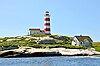
Point Amour Lighthouse
|
Canada Labrador
|
Belle Isle Street
|
51 ° 27 '37.7 " N , 56 ° 51' 29.4" W.51.46048 -56.85817
|
1857
|
33 m
|
46 m
|
Oc.W.20s
|
|
|
Cape Race Lighthouse
|
Canada Newfoundland
|
North Atlantic
|
46 ° 39 ′ 32.5 " N , 53 ° 4 ′ 24.6" W.46.65902 -53.07351
|
1856/1907
|
29 m
|
52 m
|
Fl.W.7.5s
|

|
|
Cape Enrage Lighthouse
|
Canada New Brunswick
|
Bay of Fundy
|
45 ° 35 '38.3 " N , 64 ° 46' 47.8" W.45.593969 -64.779956
|
1838/1870
|
9 m
|
38 m
|
Fl.G.6s
|

|
|
Mulholland Point Lighthouse
|
Canada New Brunswick
|
North Atlantic
|
44 ° 51 '47.2 " N , 66 ° 58' 46.5" W.44.8631 -66.97958
|
1885
|
13 m
|
20 m
|
deleted (1963)
|

|
|
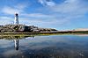
Sambro Island Lighthouse
|
Canada Nova Scotia
|
North Atlantic
|
44 ° 26 '12.3 " N , 63 ° 33' 47.8" W.44.43676 -63.56327
|
1759
|
25 m
|
43 m
|
Fl.W.5s
|
|
|
Peggy's Point lighthouse
|
Canada Nova Scotia
|
North Atlantic
|
44 ° 29 '30.4 " N , 63 ° 55' 6.9" W.44.49178 -63.91857
|
1868/1915
|
13 m
|
22 m
|
Fl.R.5s
|
|
|
St. David's Lighthouse
|
Bermuda Saint David's Island Saint David's Island
|
North Atlantic
|
32 ° 21 ′ 50.4 " N , 64 ° 39 ′ 6" W.32.364 -64.65166
|
1879
|
22 m
|
65 m
|
Fl (2) W.20s
|

|
|
Gibbs Hill Lighthouse
|
Bermuda Grand Bermuda
|
North Atlantic
|
32 ° 15 '10.2 " N , 64 ° 50' 5.1" W.32.25282 -64.83475
|
1846
|
41 m
|
108 m
|
Fl.W.10s
|

|
|
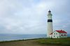
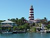
Elbow Cay Lighthouse
|
Bahamas Abaco Islands Abaco Islands
|
Sargasso lake
|
26 ° 32 '23.1 " N , 76 ° 57' 43.7" W.26.53975 -76.96215
|
1864
|
27 m
|
37 m
|
Fl (5) W.15s
|
|
|
Paradise Island Lighthouse
|
Bahamas New Providence
|
Sargasso lake
|
25 ° 5 '12.9 " N , 77 ° 21' 5.3" W.25.08691 -77.35146
|
1817
|
19 m
|
21 m
|
Fl.W (R) .5s
|

|
|
Faro del Castillo del Morro
|
Cuba Havana Havana
|
Florida Street
|
23 ° 9 '0.8 " N , 82 ° 21' 25.9" W.23.150227 -82.357204
|
1845
|
25 m
|
44 m
|
Fl (2) W.15s
|

|
|
Faro de Cabo Cruz
|
Cuba Granma
|
Caribbean
|
19 ° 50 '28 " N , 77 ° 43' 35.9" W.19.84111 -77.726625
|
1871
|
32 m
|
34 m
|
Fl.W.5s
|

|
|
Faro de Punta de Maisí
|
Cuba Guantánamo
|
Windward Passage
|
20 ° 14 '38 " N , 74 ° 8' 34.6" W.20.243879 -74.142957
|
1862
|
31 m
|
37 m
|
Fl.W.5s
|
|
| Faro de Celarain
|
Mexico Quintana Roo Quintana Roo
|
Yucatán Street
|
20 ° 16 '21.7 " N , 86 ° 59' 16.9" W.20.2727 -86.98804
|
1908/1934
|
25 m
|
26 m
|
Fl.W.5s
|

|
|
California lighthouse
|
Aruba Aruba Aruba
|
Caribbean
|
12 ° 36 ′ 49.5 " N , 70 ° 3 ′ 5" W.12.613742 -70.051395
|
1916
|
30 m
|
55 m
|
Fl (2) WR.10s
|

|
|
Barra lighthouse
|
Brazil Bahia Bahia
|
All Saints Bay
|
13 ° 0 ′ 37.3 " S , 38 ° 31 ′ 58.4" W.-13.01035 -38.53288
|
1698/1839
|
22 m
|
39 m
|
WWR.30s
|

|
|
Farol das Conchas
|
Brazil Paraná
|
South Atlantic
|
25 ° 32 '20.8 " S , 48 ° 17" 27.1 " W.-25.53912 -48.29086
|
1872
|
18 m
|
67 m
|
Fl.W.10s
|

|
|
Faro de Cabo Polonio
|
Uruguay Rocha Rocha
|
South Atlantic
|
34 ° 24 ′ 19.4 " S , 53 ° 46 ′ 40" W.-34.405379 -53.77777
|
1881
|
26 m
|
40 m
|
Fl.W.12s
|

|
|
Faro de José Ignacio
|
Uruguay Maldonado
|
South Atlantic
|
34 ° 50 ′ 46.6 " S , 54 ° 37 ′ 58.2" W.-34.846277 -54.632821
|
1877
|
25 m
|
32 m
|
Fl.W.2s
|
|
|
Isla de Lobos
|
Uruguay Maldonado
|
South Atlantic
|
35 ° 1 ′ 28.1 ″ S , 54 ° 53 ′ 0.1 ″ W.-35.02448 -54.88337
|
1858/1906
|
59 m
|
66 m
|
Fl.W.5s
|

|
|
Faro Recalada a Bahía Blanca
|
Argentina Buenos Aires Buenos Aires
|
South Atlantic
|
38 ° 59 ′ 26.8 " S , 61 ° 15 ′ 35.8" W.-38.99078 -61.25995
|
1906
|
67 m
|
75 m
|
Fl.W.9s
|

|
|
Faro Les Éclaireurs
|
Argentina Tierra del Fuego
|
Beagle Channel
|
54 ° 52 '17.4 " S , 68 ° 4' 59.6" W.-54.8715 -68.08321
|
1920
|
11 m
|
22 m
|
Fl.W.10s
|

|
| Faro Punta Delgada
|
Chile Magallanes y de la Antártica Magallanes y de la Antártica
|
Strait of Magellan
|
52 ° 27 ′ 21.1 ″ S , 69 ° 32 ′ 42 ″ W.-52.45587 -69.545
|
1902
|
12 m
|
21 m
|
Fl.W.5s
|

|
|
Faro de Puno
|
Peru Puno Puno
|
Lake Titicaca
|
15 ° 50 ′ 7.2 ″ S , 70 ° 0 ′ 55.5 ″ W.-15.835335 -70.015408
|
|
9 m
|
10 m
|
|

|
|
Faro La Marina
|
Peru Lima
|
Pacific Ocean
|
12 ° 7 ′ 25 ″ S , 77 ° 2 ′ 24.6 ″ W.-12.123616 -77.040167
|
1900
|
22 m
|
108 m
|
Fl (3) W.15s
|

|
| El Faro de Mazatlan
|
Mexico Sinaloa
|
Pacific Ocean
|
23 ° 10 ′ 39.5 " N , 106 ° 25 ′ 39.1" W.23.17763 -106.42752
|
1879
|
11 m
|
157 m
|
Fl.W.7s
|

|
|
Fisgard Lighthouse
|
Canada British Columbia
|
Juan de Fuca street
|
48 ° 25 '49.4 " N , 123 ° 26' 51.3" W.48.43039 -123.44757
|
1860
|
15 m
|
22 m
|
Iso.WR.4s
|

|
Web links


.jpg)


.jpg)


.JPG)
.jpg)


.jpg)

