Schopfloch (Lenningen)
|
Schopfloch
community Lenningen
|
|
|---|---|
| Coordinates: 48 ° 32 '26 " N , 9 ° 31' 55" E | |
| Height : | 761.7 m above sea level NN |
| Area : | 10.95 km² |
| Residents : | 687 (Dec. 31, 2017) |
| Population density : | 63 inhabitants / km² |
| Incorporation : | 1st January 1975 |
| Postal code : | 73252 |
| Area code : | 07026 |
|
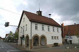
Town hall in Schopfloch
|
|
Schopfloch is a district of the municipality of Lenningen in the Esslingen district in Baden-Württemberg .
geography
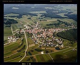
Schopfloch lies above Lenningen on the plateau of the Schopflocher Alb .
Neighboring towns are in the north of the Bissing district of Ochsenwang , in the west of the Lenning district of Gutenberg , in the south of the Römerstein district of Donnstetten and in the east of Wiesensteig .
history
The documented history of Schopfloch begins in 1182 with a document from the oldest known landlord, the Premonstratensian Monastery of Rot an der Rot . Schopfloch was in the original domain of the Zähringer and was taken over by Adalbert, who later became Duke of Teck . In 1387 rule passed to Württemberg .
In the middle of the 15th century, Schopfloch consisted of 21 households and six people without a house. During the Thirty Years' War the village of 100 people was badly destroyed and looted, the number of inhabitants had dropped to 40 by 1644. In 1703, 206 people lived in the village again. By 1800 the population had even increased to 402 people.
Schopfloch belonged to the Württemberg Oberamt Kirchheim , from 1938 to 1972 to the district of Nürtingen and since 1973 to the district of Esslingen .
On January 1, 1975, Oberlenningen , Unterlenningen , Gutenberg and Schopfloch merged to form the municipality of Lenningen.
coat of arms
The official blazon of the coat of arms reads: In green a fallen silver ploughshare.
Public facilities
There is a municipal kindergarten and a primary school in Schopfloch. The Schopfloch fire department is a division of the Lenningen volunteer fire department .
traffic
- The state road L 1212 runs through Schopfloch from Weilheim to Römerstein . The bus lines 176 and 177 stop at the stops "Rathaus" and "Reußensteinstraße" and promise adequate transport connections.
Attractions
Heinrich Schickhardt discovered the Schopflocher peat bog as early as 1626 and began mining peat for heating purposes. The Schopfloch Moor was created due to the Randecker Maar , which is located in the Ochsenwang district and is a former volcanic vent of the Swabian volcano. In the centuries that followed, peat was repeatedly extracted. The Schopfloch peat bog is today the only larger raised bog in the Swabian Alb . On February 26, 1942, the moor was placed under nature protection. The Schopflocher Moor is the oldest nature reserve in the Esslingen district.
Today's Protestant church was built in 1782 by Johann Adam Groß the Elder. J. built.
Schopfloch is a popular recreational destination in summer thanks to its many hiking trails and in winter thanks to its ski lifts.
Individual evidence
- ^ Federal Statistical Office (ed.): Historical municipality directory for the Federal Republic of Germany. Name, border and key number changes in municipalities, counties and administrative districts from May 27, 1970 to December 31, 1982 . W. Kohlhammer, Stuttgart / Mainz 1983, ISBN 3-17-003263-1 , p. 461 .
literature
- Esslingen district (ed.): The Esslingen district. Stuttgart 1978, page 218.
- State Archives Baden-Württemberg i. V. with the district of Esslingen (ed.): The district of Esslingen. Jan Thorbecke Verlag, Ostfildern 2009, ISBN 978-3-7995-0842-1 , Volume 2, page 148.
- Rainer Kilian (Ed.): Schopfloch: History of a community in the Swabian Alb. Gottlieb & Osswald, Kirchheim unter Teck 2004, ISBN 3-925589-31-7 .


