Schorgast
| Schorgast | ||
| Data | ||
| Water code | DE : 24118 | |
| location |
Bavaria
|
|
| River system | Rhine | |
| Drain over | White Main → Main → Rhine → North Sea | |
| source | in the eastern municipality of Marktschorgast 50 ° 6 ′ 4 ″ N , 11 ° 40 ′ 45 ″ E |
|
| Source height | approx. 534 m above sea level NN | |
| muzzle | near Ködnitz -Kauerndorf in the White Main Coordinates: 50 ° 6 '46 " N , 11 ° 30' 5" E 50 ° 6 '46 " N , 11 ° 30' 5" E |
|
| Mouth height | 308 m above sea level NN | |
| Height difference | approx. 226 m | |
| Bottom slope | approx. 12 ‰ | |
| length | 19.5 km (longest strand with Perlenbach 29.7 km) | |
| Catchment area | 247.69 km² | |
| Discharge at the Kauerndorf A Eo gauge: 246.23 km² Location: 780 m above the mouth |
NNQ MNQ 1961–1999 MQ 1961–1999 Mq 1961–1999 MHQ 1961–1999 HHQ (05/28/2006) |
78 l / s 1.39 m³ / s 3.71 m³ / s 15.1 l / (s km²) 46.1 m³ / s 106 m³ / s |
| Discharge A Eo : 247.8 km² at the mouth |
MQ Mq |
3.74 m³ / s 15.1 l / (s km²) |
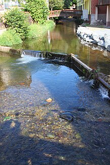
The Schorgast is a 19 km long right tributary of the White Main in Upper Franconia . The longest stretch over the Perlbach has a length of almost 30 km.
geography
course
The still largely natural Schorgast, after which the valley is named, has its source in the eastern municipality of Marktschorgast . Part of the springs there used to be used to supply the community with drinking water. The Bamberg - Hof railway line, part of the Ludwig-Süd-Nord-Bahn from Lindau to Hof, touches the south-eastern edge of the Schorgast catchment area above the Inclined Plane . A little west of Marktschorgast, the Perlbach, a good five times as rich in water and a good ten kilometers longer, flows into the stream from the north, making it the main strand of the Schorgast river system in terms of water science . On its further course to the west, the Schorgast takes on the Weißenbach, its equal Koser and the Untere Steinach .
The Schorgast flows through the towns of Marktschorgast , Wirsberg , Ludwigschorgast and Untersteinach . At Ködnitz -Kauerndorf it flows as a small river with an average water flow of 3.74 m³ / s into the White Main, which is only around 13% larger there.
Schorgast river system
The river system of the Schorgast is almost tree-like (dendritic), which is reflected in the frequent confluence of almost equally large watercourses (Schorgast - Koser, Große and Kleine Koser, Schorgast - Untere Steinach, Schlackenmühlbach - Großer Rehbach) and at the same time the risk of adding flood peaks brings itself. In the area of the Franconian Forest there are transitions to a parallel structure. The most important collecting line is the Franconian Line along the western edge of the Franconian Forest, along which the largest flowing waters of the system, Schorgast and Untere Steinach, converge.
For details of the rivers, see the lists of rivers in the Schorgast river system and in the higher-level Weißer Main river system .
Tributaries
- Perlenbach ( right ), 13.6 km, 27.1 km², at the Marktschorgast - Grundmühle , 438 m above sea level. NHN
- Weißenbach ( right ), 3.2 km, south-southeast of Wirsberg - Weißenbach , 409 m above sea level. NHN
- Koser ( Koserbach ) ( right ), 14.0 km, 38.2 km², in Wirsberg, 369 m above sea level. NHN
- Buchbächlein with lower course Gerbersbach ( right ), before Ludwigschorgast , 335 m above sea level. NHN
- Steckbach ( left ), 0.5 km (with Hutweidbach left upper course 4.9 km), at Lettenhof von Neuenmarkt , 324 m above sea level. NHN
- Arnitz ( right ), 2.5 km, after the wire mill of Ludwigschorgast, 322 m above sea level. NHN
- Untere Steinach ( right ), 24.7 km and 139.5 km², on the southern edge of Untersteinach , 316 m above sea level. NHN
Individual evidence
- ↑ a b TOP 10 Bavaria North
- ↑ a b Directory of stream and river areas in Bavaria - Main river area, page 6 of the Bavarian State Office for the Environment, as of 2016 (PDF; 3.3 MB)
- ^ Bavarian flood news service (as of September 7, 2013)
- ↑ Extrapolation to the entire catchment area
- ↑ Level Adlerhütte (Koser) and Wirsberg (Schorgast)
- ↑ Note: Weißer Main at the confluence point: 4.21 m³ / s, Schorgast: 3.74 ³ / s
- ↑ Measured according to the background map: First recording (1808-1864) because today it is mostly underground
Web links
- Course of the Schorgast on the BayernAtlas
- Level near Wirsberg, HND Bavaria
- Gauge near Kauerndorf, HND Bavaria
