
Schulenburg (Langenhagen)
|
Schulenburg
City of Langenhagen
|
||
|---|---|---|
.png) |
||
| Height : | 53 m above sea level NHN | |
| Area : | 3.93 km² | |
| Residents : | 2356 (Jan 31, 2020) | |
| Population density : | 599 inhabitants / km² | |
| Incorporation : | March 1, 1974 | |
| Postal code : | 30855 | |
| Area code : | 0511 | |
Location of Schulenburg in Lower Saxony |
||
 View from Schulenburg-Nord to the airport tower
|
||

Schulenburg is a district of the city of Langenhagen in the Hanover region of Lower Saxony .
geography
Schulenburg is located southwest of Hanover-Langenhagen Airport in parts directly on the runway; the northern runway runs across the district. The neighboring town to the east is Godshorn , to the south the Hanoverian district of Nordhafen and to the west Engelbostel .
The place is divided between the Kananohe nature reserve in the north and the Schulenburg industrial park in the south of the municipality in Schulenburg-Nord, Schulenburg-Mitte and, separated by the A 352 federal motorway , Schulenburg-Süd. The connection between Schulenburg and Schulenburg-Nord was interrupted in the 1950s by the construction of the southern runway at Hannover-Langenhagen Airport ; since then, Schulenburg-Nord has been connected via Engelbostel . Due to the development of a large new building area on Dorfstraße, the landscape joint closes to the west of Engelbostel. Schulenburg-Mitte and Engelbostel are effectively growing together.
The future of Schulenburg-Nord is uncertain. This smallest part of the village with only 50 inhabitants is located between the runways. The airport is buying up individual properties; the demolition of houses has started. It is expected that Schulenburg-Nord will have to give way to the airport's expansion plans in the medium term. To the west of the airport, a nine-hectare industrial area Airport-West is being built on the Schulenburg arable land , which will be accessed from the east through a tunnel under the airport site and thus not via Schulenburg.
history
The name Schulenburg developed from "Schulenborch", which, when the forest was cleared around 1200, had a meaning in the sense of "to the mountain place (hiding place)".
Schulenburg was first mentioned in a document in 1308. The 700th anniversary of the place was in 2008 a. a. honored with a knight festival. The War of the Succession of Lüneburg brought Schulenburg into the administration of the Vogtei Lauenrode in 1371. A tax list from 1585 shows eight farmers who lived in Schulenburg.
Incorporations
For the regional reform in Lower Saxony , Schulenburg was incorporated into the city of Langenhagen on March 1, 1974.
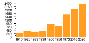
Population development
| year | Residents | source |
|---|---|---|
| 1910 | 300 | |
| 1925 | 417 | |
| 1933 | 383 | |
| 1939 | 454 | |
| 1950 | 917 | |
| 1956 | 788 | |
| 1973 | 1603 | |
| 2016 | 1985 | |
| 2020 | 2356 |
|
politics
Local council
The Schulenburg local council is composed of a councilwoman and six councilors from the following parties:
(Status: local election September 11, 2016)
Local mayor
The local mayor of Schulenburg is Dietmar Grundey (CDU). His deputy is Friedhelm Grote (SPD).
coat of arms
The Schulenburg municipal coat of arms was designed by the heraldist and graphic artist Alfred Brecht , who designed all the coats of arms in the Hanover region. The approval of the coat of arms was granted on February 15, 1962 by the district president in Hanover.
|
|
Blazon : “ Red : gold divided , above a striding, looking, blue - armored , golden lion ( leopard ), below growing outof the base of the shield a hollowed, green trunk with dead branches on the right and left, each accompanied by a green acorn . " |
| Justification of the coat of arms: The golden lion (leopard) on a red background symbolizes the centuries-long supremacy of the Guelph princes since the early days; the hollow trunk is supposed to symbolize the place name "hiding place" and at the same time the cleared forest here. The local history and the interpreted place name alone offered essential support for the design of the municipal coat of arms. |
Culture and sights
In Schulenburg-Nord there is one of the well-known Langenhagener planespotter places, directly on the north runway, where landing aircraft pass in the immediate vicinity.
The Südsee recreation area is located in Schulenburg-Süd and came into the possession of the city of Langenhagen in 1986.
Architectural monuments
Economy and Infrastructure
In Schulenburg-Mitte there is a day-care center and a fire station as well as the village community center. There is the rifle house, home of SSV Schulenburg and the fishing lake.
Schulenburg-Süd is characterized by an intensive commercial settlement and the town's only supermarket is located on the thoroughfare.
Schulenburg is served by three GVH bus routes (460, 461, 480). They offer both inland connections and travel options to and from Hanover, Langenhagen, Garbsen , Resse and Mandelsloh or Stöckendrebber .
The district does not have its own parish and no elementary school. The Schuleburg children go to the Engelbostel primary school and the Protestant part of the population belongs to the Engelbostel parish . The Catholic population belongs to the St. Hedwig community in Hanover-Vinnhorst .
Sons and daughters of the place
- Friedrich Klug (1908–1943), accountant, resistance fighter and politically persecuted by the Nazi regime
literature
- Christa Röder, Fritz-Otto Grebowicz, Lisa Lehmann: Schulenburg, history and stories. Langenhagen 2008.
Web links
Individual evidence
- ↑ a b Lower Saxony State Administration Office (ed.): Community directory for Lower Saxony . Municipalities and municipality-free areas. Self-published, Hanover January 1, 1973, p. 24 , District of Hanover ( digitized [PDF; 21.3 MB ; accessed on February 14, 2020]).
- ↑ a b Figures, data, facts - general information, statistics of the city of Langenhagen. In: Website City of Langenhagen. January 31, 2020, accessed February 14, 2020 .
- ^ Federal Statistical Office (ed.): Historical municipality directory for the Federal Republic of Germany. Name, border and key number changes in municipalities, counties and administrative districts from May 27, 1970 to December 31, 1982 . W. Kohlhammer, Stuttgart / Mainz 1983, ISBN 3-17-003263-1 , p. 196 .
- ^ Ulrich Schubert: Register of municipalities in Germany 1900 - District of Hanover. Information from December 1, 1910. In: gemeindeververzeichnis.de. January 5, 2020, accessed February 14, 2020 .
- ↑ a b c Michael Rademacher: German administrative history from the unification of the empire in 1871 to the reunification in 1990. District of Hanover ( see under: No. 64 ). (Online material for the dissertation, Osnabrück 2006).
- ↑ a b Statistisches Bundesamt Wiesbaden (ed.): Official municipality register for the Federal Republic of Germany - 1957 edition (population and territorial status September 25, 1956, for Saarland December 31, 1956) . W. Kohlhammer, Stuttgart 1958, p. 160 ( digitized version ).
- ↑ Numbers, data, facts - general information, statistics of the city of Langenhagen. In: Website City of Langenhagen. January 31, 2020, archived from the original on August 22, 2017 ; accessed on February 14, 2020 .
- ↑ a b Local council of Schulenburg. In: Citizen information system of the city of Langenhagen. Retrieved August 23, 2017 .
- ^ A b Landkreis Hannover (ed.): Wappenbuch Landkreis Hannover . Self-published, Hanover 1985, p. 236-239 .