
Kaltenweide
|
Kaltenweide
City of Langenhagen
|
||
|---|---|---|
 |
||
| Height : | 48 m above sea level NHN | |
| Area : | 22.33 km² | |
| Residents : | 8177 (Jan 31, 2020) | |
| Population density : | 366 inhabitants / km² | |
| Incorporation : | March 1, 1974 | |
| Postal code : | 30855 | |
| Area code : | 0511 | |
Location of Kaltenweide in Lower Saxony |
||

Muswillensee in the Bissendorfer Moor
|
||

Kaltenweide is a district of the city of Langenhagen in the Hanover region of Lower Saxony .
geography
The place borders in the north and northwest on the villages of Bissendorf-Wietze and Resse in the municipality of Wedemark and in the east on Isernhagen . To the south lie the Langenhagen district of Krähenwinkel and to the west the district of Engelbostel .
history
_IMG_3321.jpg)
The place was first mentioned in 1255 with the settlement of Wagenzelle, which was assigned to Kaltenweide in the 15th century. Between 1830 and 1833 the municipality of Kaltenweide was created through the merger with the settlements of Wagenzelle, Hainhaus, Maspe, Twenge and Altenhorst. Today the district includes the village locations Twenge-Siedlung and Kiebitzkrug.
The district of Kaltenweide includes the entire western municipal area up to the village of Resse with the Kaltenweider Moor, the southern part of the Bissendorfer Moor nature reserve with the Muswillensee and the Ellernbruch landscape conservation area. This makes Kaltenweide the largest town in the city of Langenhagen with an area of 22.33 km².
In the north of Kaltenweide, the new development area Weiherfeld with apartment buildings, terraced houses and detached single-family houses as well as a shop center with associated social facilities was built in 1994 . Thanks to the largest new development in the Hanover region, the number of inhabitants in Kaltenweide has more than doubled. A combined heat and power plant from the Energie-Projekt-Gesellschaft (EPL) supplies the area in a local heating network. In 2008 the first biogas plant in Langenhagen was built north of Weiherfeld . In the summer of 2009, the newly created local recreation area Scherenhorster Berg in the north of the district was opened.
Incorporations
For the territorial reform in Lower Saxony , Kaltenweide was incorporated into the city of Langenhagen on March 1, 1974.
Population development
| year | Residents | source |
|---|---|---|
| 1910 | 744 | |
| 1925 | 775 | |
| 1933 | 820 | |
| 1939 | 907 | |
| 1950 | 1589 | |
| 1956 | 1452 | |
| 1973 | 2589 | |
| 2016 | 8040 | |
| 2020 | 8177 |

|
politics
Local council
The local council of Kaltenweide consists of two councilors and eight councilors from the following parties:
(As of January 1, 2019)
Local mayor
The local mayor is Reinhard Grabowsky (CDU). His deputies are Domenic Veltrup (CDU) and Andreas Eilers (WG-AfL).
coat of arms
The design of the municipal coat of arms of Kaltenweide comes from the heraldist and author Conrad von Witzleben-Wurmb . The approval of the coat of arms was granted on August 25, 1971 by the district president in Hanover.
|
|
Blazon : " Shield split from black and silver , on the right five golden ears of wheat (2: 1: 2), on the left a right black tip , surrounded by twoblack windmill blades growing out of the gap." |
| Foundation of the coat of arms: Kaltenweide is still today a strongly rural district of Langenhagen with a purely rural history. Special coat of arms symbols were not available. The ear of wheat was therefore initially chosen as a general rural symbol and its five number was used to indicate the various districts. They alone would have resulted in a generally rural coat of arms, but not yet one typical of Kaltenweide. So you came to a split in the shield and in the other field reached again to a division that creates a "K" (the first letter of the place name), and covered this with two windmill blades. The well-known and visible post mill, which stands on the outskirts and was operated with wind until the 1950s, is very typical for Kaltenweide. Ultimately, however, the idea of the letter “K” is contained in the cross of the wings, so that the general “K” has now become a “K” special for Kaltenweide through the use of the wings. Since there were no special typical colors, black was chosen as the basic color (which could also be interpreted as arable or bog soil) and the natural yellow (gold) for the ears. The wings should be dark (black), but of course in a wood tone. The rest remained white (silver). The result was the following statement: Embedded in the black of the earth, the metals gold and silver. The mill wings symbolize the work of the people (for "the technology" as it were), who process the gift of nature (the grain) into "daily bread". A primal process which - translated - should remain valid for all time. |
Culture and sights
_IMG_8842.jpg)
Buildings
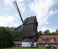
- In the Wagenzelle district there is a functional post mill , which was originally built in 1602 between Bissendorf and Wennebostel . It is considered to be the oldest windmill in Northern Germany . In the 19th century, the mill was modernized with wear parts that were no longer made of wood, but of iron. In 1878 it was moved to its current location in the course of the owner's marriage. After the miller changed in 1920, the new miller raised the mill with a base building, which is unusual for post mills. In 1963 the commercial operation was stopped, which at that time was no longer using wind power. In 1972 the first restoration work was carried out on the mill, during which the mill house received new boards. The privately owned mill has been open to the public since 1983.
- The local bell tower , a monument from 1900 , is also located on Kananoher Straße in the center of the village. The tower was the bell carrier for the local bell attached to an outbuilding of the village school.
Granite boulder
- On Kananoher Straße in the center of the village there is a granite boulder, the Ortstein , approx. 2.8 m long, 2.1 m wide and 1.6 m high and weighing around 12 tons. It was found during earthworks to extend the airport in June 1990 and brought to this location. The usual classification as a natural monument is omitted because the stone has been provided with an inscription.
Post mill wagon cell

Local bell tower

school

Granite boulder
_IMG_8579.jpg)
_IMG_8577.jpg)
_IMG_8568.jpg)

Economy and Infrastructure

On the occasion of Expo 2000 , the S-Bahn was built from Hanover main station in the direction of Hanover-Langenhagen Airport and in the northern settlement area to Kaltenweide as far as Wedemark. This gave Kaltenweide its own S-Bahn stop. The connection to the center of Langenhagen is ensured via three bus lines. Thus, Kaltenweide is well connected to Langenhagen and Hanover. The local development takes place in Weiherfeld around the S-Bahn stop. The center of the district is Kaltenweider Platz with the bright red sculpture Augenhand by Ren Rong . Here are also the quite extensive shopping facilities with supermarkets, pharmacy, bakery and other shops.
There is a primary school and four day-care centers in Kaltenweide.
Personalities
People connected to the place
- Elisabeth Granier (1870–1951), teacher and headmistress, the Kaltenweider Elisabeth-Granier-Passage was named after her
- Helene Weber (1881–1962), politician (center, CDU), the Helene-Weber-Weg in Kaltenweide was named after her
- Rudolf Diels (1900–1957), lawyer, first head of the Gestapo , district president of the Cologne district , lived after the end of the war on his estate in Kaltenweide-Twenge, which he sold in 1955
- Friedhelm Fischer (* 1955), politician (SPD), mayor of Langenhagen, lived in Kaltenweide
- Susanne Schott-Lemmer (* 1965), politician (CDU), from 1992 she was parliamentary group spokeswoman in the local council of Kaltenweide, became local mayor there in 1996 and moved into the council of the city of Langenhagen
literature
- Wilfried Münkel, Christa Mayer-Höhne: From life in a Hanoverian village: the history of the village of Kaltenweide in pictures . Self-published, Langenhagen 1986 (out of print).
Web links
Individual evidence
- ↑ a b Figures, data, facts - general information, statistics of the city of Langenhagen. In: Website City of Langenhagen. January 31, 2020, accessed February 18, 2020 .
- ^ Federal Statistical Office (ed.): Historical municipality directory for the Federal Republic of Germany. Name, border and key number changes in municipalities, counties and administrative districts from May 27, 1970 to December 31, 1982 . W. Kohlhammer, Stuttgart / Mainz 1983, ISBN 3-17-003263-1 , p. 196 .
- ^ Ulrich Schubert: Register of municipalities in Germany 1900 - District of Hanover. Information from December 1, 1910. In: gemeindeververzeichnis.de. January 5, 2020, accessed February 18, 2020 .
- ^ A b c Michael Rademacher: German administrative history from the unification of the empire in 1871 to the reunification in 1990. District of Hanover ( see under: No. 38 ). (Online material for the dissertation, Osnabrück 2006).
- ↑ a b Statistisches Bundesamt Wiesbaden (ed.): Official municipality register for the Federal Republic of Germany - 1957 edition (population and territorial status September 25, 1956, for Saarland December 31, 1956) . W. Kohlhammer, Stuttgart 1958, p. 159 ( digitized version ).
- ↑ Lower Saxony State Administration Office (ed.): Municipal directory for Lower Saxony . Municipalities and municipality-free areas. Self-published, Hanover January 1, 1973, p. 23 , District of Hanover ( digitized [PDF; 21.3 MB ; accessed on February 18, 2020]).
- ↑ Numbers, data, facts - general information, statistics of the city of Langenhagen. In: Website City of Langenhagen. January 31, 2020, archived from the original on August 22, 2017 ; accessed on February 18, 2020 .
- ↑ a b Local council of Kaltenweide. In: Citizen information system of the city of Langenhagen. Retrieved May 14, 2019 .
- ^ Coats of arms drafts by Conrad von Witzleben-Wurmb. In: Wikimedia Commons. Retrieved August 22, 2017.
- ^ A b Landkreis Hannover (ed.): Wappenbuch Landkreis Hannover . Self-published, Hanover 1985, p. 228-229 .
- ↑ Wagenzeller post mill. In: Website City of Langenhagen. Retrieved September 27, 2017 .
- ↑ Kaltenweide local bell. In: Website of the weekly newspaper Echo. Retrieved September 27, 2017 .
- ↑ Granite boulder from the Ice Age. In: Website City of Langenhagen. Retrieved September 27, 2017 .