
Schwedenschanze Isingerode
The Schwedenschanze Isingerode , also known as the Isiburg since the excavations in 2006 , is a ring wall from the late Bronze Age , which is located near Isingerode in Lower Saxony . The fortifications and outlying areas were destroyed several times by fire and were built around 1200 BC. And was in a first phase up to 600 BC. Used. The complex is interpreted as a fortified central settlement of the Lausitz culture with parallels to the nearby Hünenburg near Watenstedt . The facility was used again in the late Iron Age around the birth of Christ, when it served a Germanic population as a fortified settlement. Archaeological investigations at the facility began in 2006 and have not been completed until today (2014) after eight annual excavation campaigns.

location

The fortifications were conveniently located in terms of traffic, as a supraregional east-west long-distance route passed nearby, which crossed the Oker as a ford near Schladen . The ring wall was built on a gravel plateau formed during the Ice Age . Protection from approach in the west was provided by a 25-meter-deep steep slope to the then marshy Oker lowlands. To the north and south, the system was protected in the immediate vicinity by cross cuts in the slope. In the surrounding area, the Great Bruch valley in the north and the Ilse river valley in the east offered protection from approach.
The area of the Schwedenschanze underwent major changes in the 1930s and 1950s when the western half of the fortification was destroyed by gravel mining . The remains of the castle ramparts are now on farmland at the edge of the forest and a small part in a forest that was created in the 20th century and is designated as a landscape protection area.
Naming
The fortifications are first mentioned in writing on a map from 1898, in which they are referred to as Schwedenschanze . From the naming it can be concluded that the ramparts were still visible in the area at that time. The designation as Schwedenschanze is based on the frequent misconception that they were ringwalls that while the population of the Thirty Years' War in Catholic areas as Fliehburg had erected to protect against the Protestant Swedish troops, or even by the Swedish troops as Schanze created were. After the first excavations in 2006, the excavators announced that they would no longer use the name “Schwedenschanze” because it did not correspond to the historical background of the facility. Since then, the term "Isiburg" has established itself in everyday language.
Prospecting and excavations

As early as the 1950s, a local researcher found numerous ceramic shards from the late Bronze Age during on-site visits. Before the first excavation in 2006, extensive research was carried out in historical map material and on old aerial photographs in order to obtain information about the earlier conditions of the facility. Later it came to prospecting by geomagnetic measurements to explore the structures in the underground. The excavations were carried out by members of the Association of Friends of Archeology in Braunschweiger Land (FABL) under the scientific direction of the archaeologist Wolf-Dieter Steinmetz from the Braunschweigisches Landesmuseum until around 2016.
Found objects
During the excavations so far (as of 2013) 16 bronze finds have been recovered, including a sickle, a fragment of a lance tip, spirals, rings, jewelry and an arrowhead. Other finds were fragments of pottery and bone material from cattle and pigs. There was also a larger cult stone dating from around 700 BC. Chr. Is attributed.
construction
The fortifications took up an oval area of about 140 × 180 meters and consisted of an inner and an outer ring. The inner, older ring was a wide wall with a trench in front. The outer ring was formed by a wall with a wooden frame wall, which was protected by a moat on the outside. Both systems did not exist at the same time, but at different times, with the inner wall being replaced by the outer one. Both fortifications have gate passages up to 6 meters wide, but these do not refer to each other, which is an indication that the systems existed at the same time.
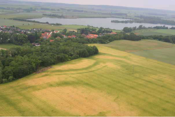
The rampart and the remains of the wooden frame wall are no longer visible in today's terrain. They have been eroded over the centuries and have been leveled by agricultural use. It was not until the excavations that began in 2006 that insights into the preservation of the wall and ditch in the subsoil were possible. Accordingly, the embankment was still present in the ground to a depth of 1.6 meters. The inner and outer trenches were preserved to a depth of four and two meters. In aerial photographs, the location of the weir ditches of the inner and outer ring is still visible on the surface based on vegetation features in the field. The plants stand out in the course of the ditch with a deeper green, as they thrive better in the deeper subsoil of the ditch.
As with other Bronze Age structures, traces of settlement were found in the interior of the fortification. For the archaeologists, they presented themselves as post holes and wall trenches of buildings as well as hearths and fireplaces. At one point, in a layer of ash, lay fallen and charred boards of a former wooden building. In addition, the floor plans of two six-meter-wide houses, each with a central fireplace, were found that overlapped.
Building history
The development of the fortification could be reconstructed on the basis of found pottery as well as C14 dating . Around 1200 BC At first an unfortified settlement was built on the area. A short time later (but still in the 12th century BC) the complex was protected by a fortification that was built as a flat wall with a wooden wall and a ditch in front of it. Since the wall was also built with earth material from the interior, a ditch was created, which was filled with municipal waste over time, which made today's dating possible. The first fortification burned down for unknown reasons. Then it was in the 12th to 10th centuries BC. Chr. Shifted to the outside by an advanced fortification. It was a wall with a wooden frame wall and a ditch in front of it. This facility was also destroyed by fire.
Around 700 BC The outer wall was rebuilt with a width of nine meters. It was crowned with a 1.4 meter wide wooden box wall. A wooden palisade supported the wall towards the ditch in front. This plant also burned down. Shortly afterwards, but still in the late Bronze Age, there was a retreat to the inner fortification ring, which was reactivated by digging the old trench. Over time, the moat apparently lost its defensive function and was used as a waste dump. In the early Iron Age around 600 BC The finds break off from the ditch, so that the 600-year history of the complex was initially over.
Around the time of the birth of Christ, more than half a millennium after the fortification was abandoned, it was repaired again. In doing so, the users at the time dug the filled trench of the inner fastening ring to a depth of 2.2 meters below the current surface. The trench was given the enormous width of 12 meters. The pottery found in it could be attributed to the Germanic tribe of the Hermunduren from the group of the Elbe Germans .
rating
The Schwedenschanze Isingerode was a central settlement from the late Bronze Age that was fortified by a ring wall. It is also seen as a traffic junction in the extensive trade in raw materials in bronze , which was on a long-distance national route. The facility is assigned to the Saale estuary group of the Lausitz culture , which found its westernmost distribution here. The first phase of use of the ring wall system lasted from around 1200 BC. Until about 600 BC Chr. There are similarities to the nearby Hünenburg near Watenstedt . Both plants had an external settlement. They are viewed as the central locations of a settlement, the settlement areas of which were about 20 kilometers apart. Similar facilities were the Röderhof on the Huy and the Burgberg near Quedlinburg . A second, shorter period of use of the Schwedenschanze as a fortified settlement was the time around the birth of Christ by a Germanic population. During this time, Roman conquests took place in the Germania magna and there were Germanic tribal conflicts.
literature
- Sigrun Ahlers: Topographical-archaeological investigations into prehistoric and early historical fortifications in the districts of Gifhorn, Helmstedt and Wolfenbüttel and in the urban district of Wolfsburg , (dissertation), Hamburg, 1988
- Wolf-Dieter Steinmetz: Dynamic events - a lot of history. The excavations 2006–2012 on the castle wall “Schwedenschanze” near Isingerode in: Archeology in Lower Saxony , 2013, pp. 54–57
Web links
- Aerial view of the Schwedenschanze Isingerode with the excavation site with growth marks in the field
- Aerial and excavation photos of the facility
- Comprehensive report on the plant and excavation as of 2006
- Dig Photos: 2007 / 2008 and 2009 / 2010
- Extensive presentation with excavation diary 2006 - 2010 ( Memento from June 18, 2010 in the Internet Archive )
- Photo showing the result of the geophysical investigation of the site
Individual evidence
- ^ Wolf-Dieter Steinmetz: Isingerode. About the excavation work of October 26, 2006
- ↑ Across the excavation line - Open Excavation Day in Isingerode, Lower Saxony at archäologie-online on August 9, 2006
- ↑ Archaeologists get to the bottom of the fort's secrets in: Volksstimme from October 24, 2013
Coordinates: 52 ° 1 ′ 5.4 ″ N , 10 ° 34 ′ 36.9 ″ E