Siegenfeld
|
Siegenfeld ( village ) locality cadastral community Siegenfeld |
||
|---|---|---|
|
|
||
| Basic data | ||
| Pole. District , state | Baden (BN), Lower Austria | |
| Pole. local community | Heiligenkreuz | |
| Coordinates | 48 ° 2 '18 " N , 16 ° 10' 37" E | |
| height | 357 m above sea level A. | |
| Residents of the village | 716 (January 1, 2020) | |
| Area d. KG | 11.94 km² | |
| Post Code | 2500 | |
| prefix | + 43/02252 | |
| Statistical identification | ||
| Locality code | 03385 | |
| Cadastral parish number | 04030 | |
| Counting district / district | Heiligenkreuz (30 613 000) | |
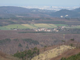
 Siegenfeld, seen from the Hohen Lindkogel |
||
| Source: STAT : index of places ; BEV : GEONAM ; NÖGIS | ||
Siegenfeld is a village near Baden (Lower Austria) in the Vienna Woods and a locality and cadastral municipality of the municipality of Heiligenkreuz .
geography
The village of Siegenfeld also includes the Rotten Krainerhütte and Rosental , the scattered Helenental houses and the cholera chapel .
history
Siegenfeld is older than Heiligenkreuz and was built around 1040. After the donation by Duke Heinrich II. "Jasomirgott", the Cistercians established the estate of the Heiligenkreuz Abbey here. The predecessor of today's church in the center of the village was built in 1414. Both the previous church and the current one are consecrated to Saint Ulrich of Augsburg .
Attractions
- Filial church St. Ulrich ( Stiftspfarre Heiligenkreuz )
- Cholera chapel
Cholera chapel in Helenental
Individual evidence
- ↑ Filialkirche Siegenfeld - Ortisei ( page no longer available , search in web archives ) Info: The link was automatically marked as defective. Please check the link according to the instructions and then remove this notice. , stiftspfarre-heiligenkreuz.at


