Sierpc
| Sierpc | ||
|---|---|---|

|
|
|
| Basic data | ||
| State : | Poland | |
| Voivodeship : | Mazovia | |
| Powiat : | Sierpc | |
| Area : | 18.60 km² | |
| Geographic location : | 52 ° 51 ′ N , 19 ° 40 ′ E | |
| Height : | 117 m npm | |
| Residents : | 17,994 (Jun. 30, 2019) |
|
| Postal code : | 09-200 | |
| Telephone code : | (+48) 24 | |
| License plate : | WSE | |
| Economy and Transport | ||
| Street : | Toruń - Lipno –Sierpc– Warsaw | |
| Rail route : | Nasielsk – Toruń | |
| Kutno-Sierpc | ||
| Next international airport : | Warsaw Airport | |
| Gmina | ||
| Gminatype: | Borough | |
| Residents: | 17,994 (Jun. 30, 2019) |
|
| Community number ( GUS ): | 1427011 | |
| Administration (as of 2020) | ||
| Mayor : | Jarosław Perzyński | |
| Address: | ul.Piastowska 11a 09-200 Sierpc |
|
| Website : | www.sierpc.pl | |
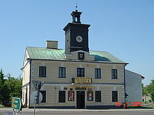
Sierpc (German: 1939 to 1941 Schirps , 1941 to 1945 Sichelberg ; Yiddish: Sheps , German in the Middle Ages: Scheps ) is a municipality (gmina miejska) and the administrative seat of the rural municipality of Sierpc in the Sierpecki Powiat , of which it is the district town. The city is located in the Masovian Voivodeship in Poland . The municipality has about 18,700 inhabitants, to which there are about 7200 inhabitants of the rural municipality of Sierpc.
geography
Sierpc is at an altitude of about 117 meters above sea level. To the north and south-west of Sierpc there is a larger forest area in the central Poland landscape, which is otherwise characterized by arable farming. The urban area extends over an area of 18.6 km², the rural community of Sierpc on an area of 150.23 km². The small river Sierpienica flows through the city from east to west and then flows into the Skrwa Right (Skrwa Prawa).
Sierpc is about halfway between the cities of Warsaw , from which Sierpc is about 125 kilometers to the northwest, and Bydgoszcz , from which Sierpc is about 110 kilometers to the southeast. The city of Włocławek is located around 45 kilometers southwest of Sierpc.
history
The first written mention of the Sierpc settlement comes from the year 1322. In 1322 the settlement received rights of self-government, which raised it to a town. Other written sources from the early 11th century indicate that some places in the area around Sierpc were in a higher position before the Christianization of the local population by the Catholic Church. Whether one of the towns and castles mentioned was precisely the present-day municipality of Sierpc has not been properly verified. During the Northern Wars with the Swedes, the district was almost completely devastated and Sierpc lost its position as a city, which the place only regained in 1867. During the German occupation , the Jewish community was destroyed and the Jewish cemetery devastated.
local community
The municipality of Sierpc (Gmina miejska) is the administrative seat of the rural municipality of Sierpc (Gmina wiejska), but is not part of it.
traffic
In the city's train station, the Kutno – Sierpc , which is no longer used for passenger traffic, crosses with the Nasielsk – Toruń railway line .
Personalities
sons and daughters of the town
- Abraham Neumann (1873–1942), Polish painter
- Tadeusz Paciorkiewicz (1916–1998), composer and music teacher
- Jerzy Adamski (1937-2002), featherweight boxer
- Peter Reisch (1943–1962), fatality on the inner-German border
- Andrzej Jacek Nowakowski (* 1971), politician, Mayor of Płocks
Web links
Individual evidence
- ↑ a b population. Size and Structure by Territorial Division. As of June 30, 2019. Główny Urząd Statystyczny (GUS) (PDF files; 0.99 MiB), accessed December 24, 2019 .
- ↑ http://biblio.unibe.ch/adam/zoom/zoom.php?col=ryh&pic=Ryh_6001_4


