Lake Silvaplana
| Lake Silvaplana (Lej da Silvaplauna) | ||
|---|---|---|

|
||
| Lake Silvaplana | ||
| Geographical location | Upper Engadine | |
| Tributaries | Inn / Sela, Fedacla , Ova dal Vallun | |
| Drain | Lej da Champfèr , ( Inn / Sela) | |
| Places on the shore | Sils Maria , Silvaplana | |
| Data | ||
| Coordinates | 780 984 / 147013 | |
|
|
||
| Altitude above sea level | 1790.54 m above sea level M. | |
| surface | 3.2 km² | |
| length | 3.1 km | |
| width | 1.4 km | |
| volume | 0.135 km³ | |
| scope | 12.716 km | |
| Maximum depth | 77 m | |
| Middle deep | 48 m | |
| Catchment area | 129 km² | |
| Water renewal time : 250 days | ||

|
||
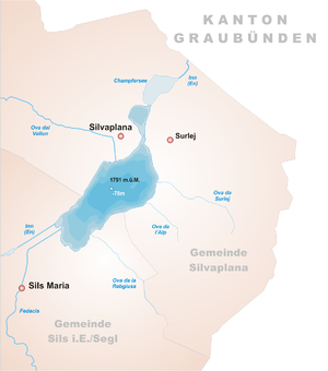
The Silvaplana lake ( Rhaeto-Romanic ) is a lake in the Upper Engadin . It is named after the village of Silvaplana and the middle of the three lakes in the Engadine Lake District. It is traversed by the Inn , which is still called Sela here . The lake merges into the Lej da Champfèr at a narrow point . This narrowing is created by the alluvial fan of Silvaplana, which is pushed further and further into the lake by the Ova dal Vallun stream .
To the south of the lake are the Surlej settlement and the Corvatsch ski area . The lake is popular with kite and windsurfers ; especially because of the steady, strong Maloja wind , which usually comes up around noon.
Varia
During a hike on Lake Silvaplana, "near a mighty, pyramidal towered block not far from Surlei", Friedrich Nietzsche said he was overcome by the idea of an Eternal Return .
Illustrations
Confluence of the Sela (Inn, in front of the street) and the Fedacla (in the alluvial fan)
See also
Web links
- Silvaplanersee on the ETHorama platform
- Silvaplana on schweizersee.ch
Individual evidence
- ↑ a b c d Seen (Federal Office for the Environment FOEN). Retrieved January 19, 2020 .


