
Skeliwka
| Skeliwka | |||
| Скелівка | |||

|
|
||
| Basic data | |||
|---|---|---|---|
| Oblast : | Lviv Oblast | ||
| Rajon : | Staryj Sambir district | ||
| Height : | no information | ||
| Area : | 3.5 km² | ||
| Residents : | 1,062 (2001) | ||
| Population density : | 303 inhabitants per km² | ||
| Postcodes : | 82052 | ||
| Area code : | +380 3236 | ||
| Geographic location : | 49 ° 32 ' N , 22 ° 58' E | ||
| KOATUU : | 4625184501 | ||
| Administrative structure : | 3 villages | ||
| Mayor : | Bohdan Antoschko | ||
| Address: | 82052 с. Скелівка | ||
| Statistical information | |||
|
|||


Skeliwka (Ukrainian Скелівка , until 1945 Фельштин; Russian Скелевка / Skelewka , Polish Felsztyn or Fulsztyn ) is a village in the western Ukrainian Lviv Oblast with about 1000 inhabitants.
The district council of the same name also includes the villages of Hlyboka ( Глибока ) and Sassadky ( Засадки ).
geography
The village is located in the Staryj Sambir district, 10 km north of the Staryj Sambir district center on the left bank of the Strywihor , a 94 km long tributary of the Dniester, and has a train station on the Stryj – Łupków railway . Territorial road T-14-18 runs through the village .
history
In 1374 Wladislaus II of Opole , the governor in the "Rus" , allocated 9 villages in the Przemyśler Land to the brothers Herbord and Frydrusz . The brothers came from Füllstein in Moravia and were the ancestors of the Herburt family , which died out in the 1st half of the 17th century. They founded a new village there, which was first mentioned in a document in 1390. It was later mentioned as Folsteyn , Felstin , Fullensteyn , Fulsthine , Fulstin or Fulsztyn . Besides Dobromyl, it was the family headquarters. A castle was built before 1400. In that year it was mentioned as a city that surrounded a moat with earth walls in the following century. Before 1418 a Roman Catholic parish with a wooden church was built, which was replaced by a brick one in the early 16th century. During this time the first Jews came. After the Herburt family , the town belonged to the Koniecpolski , Daniłowicz , Potocki , Brześciański , Mniszch and Kiegshaber families, among others .
When Poland was first partitioned in 1772, the city became part of the new Kingdom of Galicia and Lodomeria of the Habsburg Empire (from 1804). At that time it functioned as a market town. At that time there was the Roman and Greek Catholic Church and a synagogue made of wood.
In 1900 the community Felsztyn had 210 houses with 1,327 inhabitants, of which 1190 were Polish-speaking, 137 Ruthenian-speaking, 443 Roman Catholic, 194 Greek Catholic, 690 Jews.
On October 10, 1914, a battle began that largely destroyed the place.
In 1919, after the collapse of the Austro-Hungarian monarchy and the end of the Polish-Ukrainian War , Felsztyn came to Poland. In 1921 the market town had 183 houses with 1195 inhabitants, of which 668 Poles, 116 Ruthenians, 411 Jews (nationality), 528 Roman Catholic, 133 Greek Catholic, 534 Jews (religion). In 1938 the Roman Catholic parish Felsztynn in the dean's office Sambor in the diocese Przemyśl comprised 1694 parishioners, 1461 in Felsztyn, 230 in Głęboka and 3 in Bukowa .
During the Second World War it belonged first to the Soviet Union and from 1941 to the General Government , from 1945 back to the Soviet Union, now part of the Ukraine . In March 1942 the Jews were deported to Sambor and later to the Belzec extermination camp . Most of the Poles left the place after 1945.
Attractions
- Church, 15th - early 16th century, brick Gothic , formerly Roman Catholic, today Orthodox.
- Orthodox wooden church, built in 1790.
- Manor (19th century)
- Schweik figure

Castle tower and church (1914)
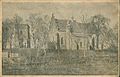
Castle tower and church (1914)
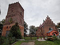
Church with a free-standing tower

grange


.jpg)
Sons and daughters

- Jan Herburt ( Joannes Herborth de Fulstin ) († 1577), Polish historian, humanist, lawyer.
- Sebastian von Felsztyn (* between 1480 and 1490; † after 1552 (?)), Polish music theorist and composer.
Web links
- Felsztyn . In: Filip Sulimierski, Władysław Walewski (eds.): Słownik geograficzny Królestwa Polskiego i innych krajów słowiańskich . tape 2 : Derenek – Gżack . Sulimierskiego and Walewskiego, Warsaw 1881, p. 382 (Polish, edu.pl ).
Individual evidence
- ↑ Central Electoral Commission of Ukraine ( Memento of the original from April 4, 2018 in the Internet Archive ) Info: The archive link was automatically inserted and not yet checked. Please check the original and archive link according to the instructions and then remove this notice.
- ↑ Grzegorz Rąkowski: Ukraińskie Karpaty i Podkarpacie, część zachodnia. Przewodnik krajoznawczo-historyczny . Oficyna Wydawnicza "Rewasz", Pruszków 2013, ISBN 978-83-62460-31-1 , p. 344-348 (Polish).
- ↑ Ludwig Patryn (Ed.): Community encyclopedia of the kingdoms and countries represented in the Reichsrat, edited on the basis of the results of the census of December 31, 1900, XII. Galicia . Vienna 1907.
- ↑ Główny Urząd Statystyczny: Skorowidz miejscowości Rzeczypospolitej Polskiej. Tom XIII. Województwo lwowskie . Warszawa 1924 (Polish, online [PDF]).
- ↑ Schematyzm Diecezji Przemyskiej Ob [rządku] Łac [inskiego] . Nakładem Kurii Biskupiej Ob. Łac., Przemyśl 1938, p. 132-139 (Polish, online ).