
Beaucens
|
Beaucens Beucens |
||
|---|---|---|
.svg)
|
|
|
| region | Occitania | |
| Department | Hautes-Pyrénées | |
| Arrondissement | Argelès-Gazost | |
| Canton | La Vallée des Gaves | |
| Community association | Pyrénées Vallées des Gaves | |
| Coordinates | 42 ° 59 ′ N , 0 ° 4 ′ E | |
| height | 434-2,637 m | |
| surface | 36.82 km 2 | |
| Residents | 409 (January 1, 2017) | |
| Population density | 11 inhabitants / km 2 | |
| Post Code | 65400 | |
| INSEE code | 65077 | |

Beaucens ( Gaskognisch Beucens ) is a French commune with 409 inhabitants (as of January 1, 2017) in the Hautes-Pyrénées department in the Occitanie region ; it belongs to the Argelès-Gazost arrondissement and the canton of La Vallée des Gaves .
location
Beaucens is located in the south of the Hautes-Pyrénées department, around 31 km (as the crow flies) south of Tarbes . The place is east of the river Gave de Gavarnie in the vicinity of the Pyrenees National Park .
The municipality consists of the village of Beaucens, numerous hamlets such as Araillès, Gézat, Nouillan, Valauris and vielle. These are all close to the east of the Gave de Pau river. There is also the Station de Hautacam ski station and some individual farms. Large parts of the community are mountainous and uninhabited. The highest point in the municipality is the Pic de Merlheu (2637 m above sea level) on the eastern border of Beaucens. The most important body of water is the Lac Bleu de Lesponne mountain lake at around 2000 meters above sea level.
history
In the early Middle Ages the rulership changed frequently (Visigoths, Basques, Franks, Saracens). After that, the place was under the rule of the Kingdom of Aquitaine and the Duchy of Gascony for centuries. From 900 to 1609 there was a county of Bigorre within the aforementioned areas. During the Hundred Years War , Beaucens was sometimes under English, sometimes under French rule. From 1425 to 1609 the place belonged as part of the County of Bigorre to the County of Foix, which is only loosely connected to France . Because the last ruler of this county, King Henry II of the House of Bourbon, ascended the throne of France (as Henry IV) in 1589, the places in the region were crown domains from 1609 to 1789. The municipality belonged to the District of Argelès from 1793 to 1801. In addition, it was from 1793 to 1801 part of the canton of Préchac and from 1801 to 2015 part of the canton of Argelès-Gazost (1793-1896 under the name of Canton Argelès ). With the exception of the years 1926 to 1942 (Arrondissement Bagnères), Beaucens was administratively part of the Arrondissement Argelès-Gazost from 1801. First mentioned by name as Belsen in 870 in the green book of Bénac. The municipality is part of the historical Lavedan landscape (also known as the Pays des Sept Vallées ).
Population development
| year | 1793 | 1836 | 1846 | 1866 | 1876 | 1926 | 1931 | 1946 | 1962 | 1968 | 1975 | 1982 | 1990 | 1999 | 2006 | 2012 |
| Residents | 379 | 491 | 502 | 468 | 445 | 265 | 361 | 237 | 260 | 247 | 244 | 249 | 309 | 350 | 426 | 421 |
| Sources: Cassini and INSEE | ||||||||||||||||
In the 19th century the place often had around 500 inhabitants. The increasing mechanization of agriculture led to a continuous decline in the number of inhabitants to the lows of recent times. Between 1982 and 2008 there was a strong growth phase (from 249 to 432 residents).
Attractions
- Ruins of the castle of Beaucens; a monument historique since 1927
- Cohitte mansion (with chapel); a monument historique since 1998
- Saint Vincent village church
- Zoo with birds of prey at the castle
- two wayside crosses
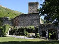
Ruins of the Château de Beaucens

Château de Beaucens with the Donjon des Aigles

The village with the château

View of Beaucens

.JPG)
.JPG)
