Pierrefitte-Nestalas
| Pierrefitte-Nestalas | ||
|---|---|---|

|
|
|
| region | Occitania | |
| Department | Hautes-Pyrénées | |
| Arrondissement | Argelès-Gazost | |
| Canton | La Vallée des Gaves | |
| Community association | Pyrénées Vallées des Gaves | |
| Coordinates | 42 ° 58 ′ N , 0 ° 4 ′ W | |
| height | 452-701 m | |
| surface | 1.76 km 2 | |
| Residents | 1,139 (January 1, 2017) | |
| Population density | 647 inhabitants / km 2 | |
| Post Code | 65260 | |
| INSEE code | 65362 | |
| Website | http://www.pierrefitte-nestalas.com/ | |
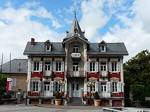
 The municipal office of Pierrefitte-Nestalas |
||
Pierrefitte-Nestalas is a French commune with 1,139 inhabitants (as of January 1, 2017) in the Hautes-Pyrénées department in the Occitanie region . Administratively, it is assigned to the Argelès-Gazost arrondissement and the canton of La Vallée des Gaves .
geography
The municipality is located in the Pyrenees , in the historic province of Bigorre , around 17 kilometers south of Lourdes . Neighboring municipalities to Pierrefitte-Nestalas are:
- Adast in the north,
- Beaucens in the northeast,
- Villelongue in the southeast
- Soulom in the south,
- Uz in the west and
- Saint-Savin in the northwest.
Pierrefitte-Nestalas is located at the confluence of the Gave de Cauterets river into the Gave de Pau , which is also called Gave de Gavarnis here .
Population development
| year | 1968 | 1975 | 1982 | 1990 | 1999 | 2009 |
| Residents | 2,054 | 1,619 | 1,527 | 1,322 | 1,260 | 1,300 |
Attractions
- Église Saint-Pierre , 14th century church - Monument historique
- Bénitier de Nestolas , holy water font from the 16th century - Monument historique
Individual evidence
- ↑ Église Saint-Pierre in the Base Mérimée of the French Ministry of Culture (French)
- ↑ Bénitier de Nestolas in the Base Palissy of the French Ministry of Culture (French)
Web links
Commons : Pierrefitte-Nestalas - Collection of images, videos and audio files
