
Ségus
| Ségus | ||
|---|---|---|
.svg)
|
|
|
| region | Occitania | |
| Department | Hautes-Pyrénées | |
| Arrondissement | Argelès-Gazost | |
| Canton | Lourdes-1 | |
| Community association | Agglomération Tarbes-Lourdes-Pyrénées | |
| Coordinates | 43 ° 4 ′ N , 0 ° 5 ′ W | |
| height | 434-1,523 m | |
| surface | 10.72 km 2 | |
| Residents | 235 (January 1, 2017) | |
| Population density | 22 inhabitants / km 2 | |
| Post Code | 65100 | |
| INSEE code | 65415 | |
| Website | Ségus | |
_2.jpg) View of the center of Ségus |
||

Ségus is a French commune with 235 inhabitants (as of January 1, 2017) in the Hautes-Pyrénées department in the Occitanie region (before 2016: Midi-Pyrénées ). The municipality belongs to the arrondissement Argelès-Gazost and the canton Lourdes-1 (until 2015: canton Lourdes-Ouest ).
The inhabitants are called Ségusiens and Ségusiennes .
geography
Ségus is located about four kilometers southwest of Lourdes in its catchment area ( Aire urbaine ) in the historic province of Bigorre .
Ségus is surrounded by the six neighboring communities:
| Omex | Lourdes | |
| Saint-Pé-de-Bigorre |
.svg)
|
Ossen |
| Salles | Ouzous |
Population development
After records began, the population rose to a high of around 435 by the middle of the 19th century. In the period that followed, the size of the community fell during brief recovery phases, with a marked decline after the First World War until the 1980s, to a low of around 155 inhabitants before a phase of growth began that has recently stagnated again.
| year | 1962 | 1968 | 1975 | 1982 | 1990 | 1999 | 2006 | 2011 | 2017 |
|---|---|---|---|---|---|---|---|---|---|
| Residents | 182 | 195 | 163 | 156 | 200 | 223 | 244 | 260 | 235 |

Attractions
- Parish Church of Saint-Pierre
- Menhir

Parish Church of Saint-Pierre

Entrance portal

Ornament on a corner of the church building
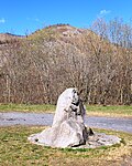
Menhir of Ségus
_2.jpg)
_4.jpg)

_1.jpg)
Economy and Infrastructure

Ségus is located in the AOC zones of the Porc noir de Bigorre pig breed and the Jambon noir de Bigorre ham .

total = 22
sport and freetime
The GR 101, a long-distance hiking trail from Maubourguet to the Col de Saucède, also runs through the center of the municipality.
traffic
Ségus is crossed by Route départementale 13.
Web links
Individual evidence
- ↑ Hautes-Pyrénées ( fr ) habitants.fr. Retrieved December 6, 2019.
- ↑ Aire urbaine de Lourdes (242) ( fr ) INSEE . Retrieved December 6, 2019.
- ^ Notice Communale Ségus ( fr ) EHESS . Retrieved December 6, 2019.
- ↑ Populations légales 2016 Commune de Ségus (65415) ( fr ) INSEE . Retrieved December 6, 2019.
- ↑ Institut national de l'origine et de la qualité: Rechercher un produit ( fr ) Institut national de l'origine et de la qualité . Retrieved December 6, 2019.
- ↑ Caractéristiques des établissements en 2015 Commune de Ségus (65415) ( fr ) INSEE . Retrieved December 6, 2019.
- ↑ GR101 - Randonnée de Maubourguet au Col de Saucède (Hautes-Pyrénées) ( fr ) gr-infos.com. Retrieved December 6, 2019.