
Gez (Hautes-Pyrénées)
|
Gez Gès |
||
|---|---|---|
.svg)
|
|
|
| region | Occitania | |
| Department | Hautes-Pyrénées | |
| Arrondissement | Argelès-Gazost | |
| Canton | La Vallée des Gaves | |
| Community association | Pyrénées Vallées des Gaves | |
| Coordinates | 43 ° 1 ′ N , 0 ° 7 ′ E | |
| height | 518-1,004 m | |
| surface | 3.89 km 2 | |
| Residents | 327 (January 1, 2017) | |
| Population density | 84 inhabitants / km 2 | |
| Post Code | 65400 | |
| INSEE code | 65202 | |

Gez ( Gaskognisch Gès ) is a French commune with 327 inhabitants (as of January 1, 2017) in the Hautes-Pyrénées department in the Occitanie region ; it belongs to the Argelès-Gazost arrondissement and the canton of La Vallée des Gaves . The residents call themselves Gézois (es) .
location
Gez is located in the southwest of the Hautes-Pyrénées department, around 29 km (as the crow flies) southwest of Tarbes . The highest point in the municipality is the Castet Sarrazi mountain west of the village. Large parts of the municipality are forested.
The community consists of the village of Gez, several hamlets and a few individual farms.
Neighboring municipalities are Sère-en-Lavedan in the north, Ouzous and Ayzac-Ost in the northeast, Argelès-Gazost in the east and southeast, Arras-en-Lavedan in the south and southwest and Salles in the northwest.
history
In the early Middle Ages the rulership changed frequently (Visigoths, Basques, Franks, Saracens). After that, the place was under the rule of the Kingdom of Aquitaine and the Duchy of Gascony for centuries. From 900 to 1609 there was a county of Bigorre within the aforementioned areas. During the Hundred Years War , Arras-en-Lavedan was sometimes under English, sometimes under French rule. From 1425 to 1609 the place belonged as part of the county of Bigorre to the county of Foix, which is only loosely connected to France . Because the last ruler of this county, King Henry III. of Navarre from the House of Bourbon, in 1589 ascended the throne of France (as Henry IV.), the places in the region were crown domains from 1609 to 1789. The municipality belonged to the District of Argelès from 1793 to 1801. It was also part of the canton of Argelès-Gazost from 1793 to 2015 . With the exception of the years 1926 to 1942 (Arrondissement Bagnères), Gez was administratively part of the Arrondissement Argelès-Gazost since 1801. First indirect mention of Gez as a Garsia de Jes in the 11th century in the copial book of Saint-Savin. The municipality is part of the historical Lavedan landscape (also known as the Pays des Sept Vallées ).
Population development
| year | 1793 | 1806 | 1821 | 1836 | 1911 | 1921 | 1946 | 1962 | 1968 | 1975 | 1982 | 1990 | 1999 | 2006 | 2012 |
| Residents | 404 | 285 | 388 | 408 | 318 | 280 | 194 | 220 | 222 | 204 | 216 | 215 | 233 | 261 | 319 |
| Sources: Cassini and INSEE; today's municipal area | |||||||||||||||
The number of residents has declined since 1793 due to emigration, the fallen in World War I and the flu wave of 1918/1919. The lowest population figures come from the post-war period.
Attractions
- Saint-Germé village church
- Memorial to the Fallen
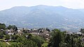
Look at Gez

Town Hall (Mairie) by Gez
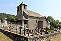
Saint-Germé village church
_1.jpg)
_1.jpg)
_1.jpg)
Web links
- Location of the municipality
- Brief information about the community
- Gez on the side of the IGN
- Photo of the Saint-Germé church