
Arcizans-Dessus
| Arcizans-Dessus | ||
|---|---|---|
.svg)
|
|
|
| region | Occitania | |
| Department | Hautes-Pyrénées | |
| Arrondissement | Argelès-Gazost | |
| Canton | La Vallée des Gaves | |
| Community association | Pyrénées Vallées des Gaves | |
| Coordinates | 42 ° 59 ′ N , 0 ° 10 ′ W | |
| height | 676-1,562 m | |
| surface | 5.01 km 2 | |
| Residents | 125 (January 1, 2017) | |
| Population density | 25 inhabitants / km 2 | |
| Post Code | 65400 | |
| INSEE code | 65022 | |
_1.jpg) View of the center of Arcizans-Dessus |
||

Arcizans-Dessus is a French commune with 125 inhabitants (as of January 1, 2017) in the Hautes-Pyrénées department in the Occitanie region (before 2016: Midi-Pyrénées ). The municipality belongs to the Argelès-Gazost arrondissement and is the capital of the canton of La Vallée des Gaves (until 2015: canton of Aucun ).
The inhabitants are called Arcizanais and Arcizanaises .
geography
Arcizans-Dessus is located about six kilometers southwest of Argelès-Gazost in its catchment area ( Aire urbaine ) in the historic province of Bigorre on the western edge of the department. The municipality is part of the Pyrenees National Park .
Arcizans-Dessus is surrounded by the four neighboring communities:
| Salles | ||
| Gaillagos |
.svg)
|
Arras-en-Lavedan |
| Bun |
Arcizans-Dessus lies in the catchment area of the Adour River . The Gave d'Azun , a tributary of the Gave de Pau , flows along the southern municipal boundary . The Ruisseau du Bergons, another tributary of the Gave de Pau, marks the border to the northern neighboring municipality of Salles.


Toponymy
The Occitan name of the municipality is Arcisans Dessús. It has its origin in the Latin proper name Arcisus with the suffix -akonums , which together means "the possession of Arcisus". The addition “Dessus” indicates the geographic location south of Arcizans-Avant .
Toponyms and mentions of Arcizans-Dessus were:
- Arcisans Subeirur (1168, papal bull of Pope Alexander III ),
- Arcisaas Sobiroo (1285, census of the nobility in Bigorre),
- De Artizanis Superiori (1313, Debita regi Navarre tax list),
- de Arcizanis Superioribus , (1379, power of attorney Tarbes ),
- Arcisaas Sobiroo , Arcisans Sobiroo and Arcisaas (1429, census in Bigorre),
- Arcisan's Dessus (1614, after Guillaume Mauran),
- Arcizans Dessus (1750 and 1793, map by Cassini or Notice Communale ),
- Arcizans (1801, Bulletin des lois ).
Population development
After the records began, the population rose to an initial high of around 340 by the first half of the 19th century. In the following period, the size of the community fell to around 85 inhabitants during short recovery phases until the 1980s, before a phase of growth began continues today.
| year | 1962 | 1968 | 1975 | 1982 | 1990 | 1999 | 2006 | 2011 | 2017 |
|---|---|---|---|---|---|---|---|---|---|
| Residents | 102 | 89 | 88 | 86 | 91 | 96 | 97 | 99 | 125 |

Attractions
Parish Church of Saint-André
It is a Romanesque church from the 12th century with a semicircular apse and a massive bell tower . It was renovated in the 18th century and was last restored in 2001. A bell rider , typical of the area, adorns the rear half of the roof of the nave . The side entrance on the southwest side has a lintel in the form of a gable roof with a Christ monogram measuring 60 cm in diameter. It is similar to that of other churches in Tal, Aucun and Arrens-Marsous . A Greek cross is engraved in the arches of the two supporting consoles on the left, and a St. Andrew's cross on the right with reference to the patron saint of the church . A second entrance under the bell tower gives access to the gallery . The former, adjoining cemetery was moved and replaced by a lawn.
The interior of the church contains a baroque altarpiece attributed to the Claverie workshops in Lourdes . The apostle Andrew shows himself with his cross in the middle . It is framed by two smooth columns of painted wood imitating marble and two saints. On the left you can see the apostle Peter with his key and on the right Paul of Tarsus with his sword. A halo decorates the upper part, in the middle of which a dove spreads its wings amid clouds. The decor is complemented by two kneeling cherubs and two large vases.
The tabernacle is attributed to Jean Brunelo. However, due to its rather large size, it is likely from another church. The central figure depicts Christ as Ecce homo in his mocking robe. He is framed in its niche by the apostles Peter and Paul. The altar in the form of a rounded tomb is decorated with angel heads and dates from the same period as the reredos (1750–1760).
The side chapel , which is dedicated to Mary with the rosary , contains a reredos similar to the main altar and can therefore be assigned to the same workshop. Here, too, it is structured by three niches that are separated by two smooth pillars that are painted with imitating marble paint. The statue Mary and baby Jesus at the center, above a halo is on the left side by John the Baptist edged to acknowledge his cross with script and the passover to his feet, and on the right by St. Joseph to recognize on his lily as a symbol of chastity. The Holy Spirit above Mary's head is there for her protection. Carpentry work dating from the 18th century is located opposite and completes the furnishings.
Every year a holy mass for the shepherds is celebrated in the church .

Parish Church of Saint-André
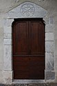
entrance
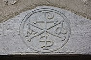
Christ monogram on the lintel of the entrance
_1.jpg)


_1.jpg)
Watermill
It is a small watermill that has been completely restored. About 300 years ago there were 22 watermills along a narrow watercourse. In the valley, on the other hand, there are over 100 mills that ground maize , barley , wheat , millet and buckwheat for the inhabitants of the valley. The guided tour is free of charge for visitors in July and August.
Economy and Infrastructure

Arcizans-Dessus is located in the AOC zones of the Porc noir de Bigorre pig breed and the Jambon noir de Bigorre ham .

total = 17
sport and freetime
The GR de Pays Tour du Val d'Azun long-distance hiking trail also passes through the center of Arcizans-Dessus.
traffic
Arcizans-Dessus is crossed by Route départementale 918, the former Route nationale 618 .
Web links
Individual evidence
- ↑ Hautes-Pyrénées ( fr ) habitants.fr. Retrieved September 17, 2019.
- ↑ Aire urbaine d'Argelès-Gazost (468) ( fr ) INSEE . Retrieved September 17, 2019.
- ↑ Ma commune: Arcizans-Dessus ( fr ) Système d'Information sur l'Eau du Bassin Adour Garonne. Retrieved September 18, 2019.
- ^ Arcizans-Dessus ( fr ) Hautes-Pyrénées department. Retrieved September 18, 2019.
- ^ David Rumsey Historical Map Collection France 1750 ( en ) David Rumsey Map Collection: Cartography Associates. Retrieved September 18, 2019.
- ↑ a b Notice Communale Arcizans-Dessus ( fr ) EHESS . Retrieved September 18, 2019.
- ↑ Populations légales 2016 Commune d'Arcizans-Dessus (65022) ( fr ) INSEE . Retrieved September 17, 2019.
- ^ Arcizans-Dessus ( fr ) Patrimoines Lourdes Gavarnie. Retrieved September 18, 2019.
- ↑ Le moulin d'Arcizans-Dessus ( fr ) Comité Régional du Tourisme Occitanie. Retrieved September 18, 2019.
- ↑ Institut national de l'origine et de la qualité: Rechercher un produit ( fr ) Institut national de l'origine et de la qualité . Retrieved September 17, 2019.
- ↑ Caractéristiques des établissements en 2015 Commune d'Arcizans-Dessus (65022) ( fr ) INSEE . Retrieved September 17, 2019.
- ↑ GRP Val d'Azun ( fr ) Fédération française de la randonnée pédestre (FFRandonnée / FFRP). Retrieved September 18, 2019.