
Boô syllables
|
Boô-Silhen Bòr e Silhen |
||
|---|---|---|
.svg)
|
|
|
| region | Occitania | |
| Department | Hautes-Pyrénées | |
| Arrondissement | Argelès-Gazost | |
| Canton | La Vallée des Gaves | |
| Community association | Pyrénées Vallées des Gaves | |
| Coordinates | 43 ° 1 ′ N , 0 ° 4 ′ E | |
| height | 399-599 m | |
| surface | 3.12 km 2 | |
| Residents | 310 (January 1, 2017) | |
| Population density | 99 inhabitants / km 2 | |
| Post Code | 65400 | |
| INSEE code | 65098 | |

Boô-Silhen ( Gaskognisch Bòr e Silhen ) is a French commune with 310 inhabitants (as of January 1, 2017) in the Hautes-Pyrénées department in the Occitanie region ; it belongs to the Argelès-Gazost arrondissement and the canton of La Vallée des Gaves .
location
Boô-Silhen is located in the south of the Hautes-Pyrénées department, around 26 km (as the crow flies) southwest of Tarbes . The place is east of the river Gave de Pau in the vicinity of the Pyrenees National Park .
The community consists of the villages Boô and Silhen, the hamlets (hameaux) Asmets and Brouca and some individual farms.
history
In the early Middle Ages the rulership changed frequently (Visigoths, Basques, Franks, Saracens). After that, the place was under the rule of the Kingdom of Aquitaine and the Duchy of Gascony for centuries. From 900 to 1609 there was a county of Bigorre within the aforementioned areas. During the Hundred Years War Boô-Silhen was sometimes under English, sometimes under French rule. From 1425 to 1609 the place belonged as part of the county of Bigorre to the county of Foix, which is only loosely connected to France . Because the last ruler of this county, King Henry II of the House of Bourbon, ascended the throne of France (as Henry IV) in 1589, the places in the region were crown domains from 1609 to 1789. The municipality belonged to the District of Argelès from 1793 to 1801. In addition, it was from 1793 to 1801 part of the canton of Préchac and from 1801 to 2015 part of the canton of Argelès-Gazost (1793-1896 under the name of Canton Argelès ). With the exception of the years 1926 to 1942 (Arrondissement Bagnères) Boô-Silhen was administratively part of the Arrondissement Argelès-Gazost since 1801. Silhen was first mentioned by name as Silien in 870 in the green book of Bénac and Boô as Bor in the copial book of Saint-Savin. The municipality is part of the historical Lavedan landscape (also known as the Pays des Sept Vallées ).
Population development
| year | 1793 | 1800 | 1806 | 1821 | 1846 | 1876 | 1946 | 1962 | 1968 | 1975 | 1982 | 1990 | 1999 | 2006 | 2016 |
| Residents | 278 | 232 | 283 | 198 | 318 | 284 | 123 | 144 | 165 | 164 | 275 | 269 | 271 | 274 | 299 |
| Sources: Cassini and INSEE | |||||||||||||||
The increasing mechanization of agriculture led to a continuous decline in the number of inhabitants to the lows in the 20th century. Between 1975 and 1982 there was a strong growth phase.
Attractions
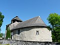
- Romanesque village church of Saint-Barthélemy in Boô from the 12th century; a monument historique since 1986
- Romanesque village church of Saint-Vincent in Silhen from the 11th and 12th centuries; a monument historique since 1986
- Asmets Church
- two wayside crosses

Saint-Barthélemy village church in Boô
Saint Vincent village church in Silhen

The Ruisseau de St-Pastous stream in Boô
.JPG)
.JPG)
