
Esquièze-Sère
|
Esquièze-Sère Esquiesa e Cèra |
||
|---|---|---|
.svg)
|
|
|
| region | Occitania | |
| Department | Hautes-Pyrénées | |
| Arrondissement | Argelès-Gazost | |
| Canton | La Vallée des Gaves | |
| Community association | Pyrénées Vallées des Gaves | |
| Coordinates | 42 ° 53 ' N , 0 ° 0' E | |
| height | 659-1,126 m | |
| surface | 1.52 km 2 | |
| Residents | 401 (January 1, 2017) | |
| Population density | 264 inhabitants / km 2 | |
| Post Code | 65120 | |
| INSEE code | 65168 | |

Esquièze-Sère ( Esquiesa e Cèra in Gaskognisch ) is a French commune with 401 inhabitants (as of January 1, 2017) in the Hautes-Pyrénées department in the Occitania region ; it belongs to the Argelès-Gazost arrondissement and the canton of La Vallée des Gaves .
location
Esquièze-Sère is located in the south of the Hautes-Pyrénées department, around 40 km (as the crow flies) south-southwest of Tarbes . Most of the village is located in the valley and on the southwest slope of the Soum de la Moustayou mountain . Esquièze is on the Bastan River , and the other districts are nearby. The entire municipality is also located in the Pyrenees National Park and is part of the Lavedan region and its sub-region Vallée de Barège .
The community consists of Esquièze, Lanne and Sère, the hamlet of Lacaret and a few individual farms.
history
In the early Middle Ages the rulership changed frequently (Visigoths, Basques, Franks, Saracens). After that, the place was under the rule of the Kingdom of Aquitaine and the Duchy of Gascony for centuries. From 900 to 1609 there was a county of Bigorre within the aforementioned areas. A sub-area of this rule was the Lavedan region , which Esquièze-Sère was part of. During the Hundred Years War Esquièze-Sère was sometimes under English, sometimes under French rule. From 1425 to 1609 the place belonged as part of the county of Bigorre to the county of Foix, which is only loosely connected to France . Because the last ruler of this county, King Henry II of the House of Bourbon, ascended the throne of France (as Henry IV) in 1589, the places in the region were crown domains from 1609 to 1789. The municipality belonged to the District of Argelès from 1793 to 1801. It was also part of the canton of Luz-Saint-Sauveur from 1793 to 2015 (1793–1962 under the name of Canton Luz ). With the exception of the years 1926 to 1942 (Arrondissement Bagnères) Esquièze-Sère was administratively part of the Arrondissement Argelès-Gazost since 1801. The two districts are first mentioned under (Sère) Bernardus de Cera (1037/1040) and (Esquièze) Ezii Guilhermi de Squisa (in the copial book of Bigorre in the 12th century). Until 1846 the community part was an independent community under the name Sère-Barèges (1836: 117 inhabitants).
Population development
| year | 1793 | 1800 | 1851 | 1856 | 1866 | 1946 | 1954 | 1962 | 1968 | 1975 | 1982 | 1990 | 1999 | 2006 | 2012 | |
| Residents | 250 | 251 | 413 | 395 | 433 | 405 | 562 | 487 | 465 | 503 | 443 | 500 | 464 | 418 | 383 | |
| Sources: Cassini and INSEE | ||||||||||||||||
Attractions
- Romanesque village church of Saint-Nicolas in Esquièze (12th century); a monument historique since 1979
- Romanesque village church of Saint-Jean-Baptiste from the 11th century in Sère; a monument historique since 1914
- Village fountain on the place de l'Arole
- the so-called grande maison blanche (from 1818) on place de l'Arole

The Bastan river with Esquièze-Sère (left)
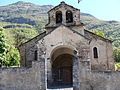
Saint-Jean-Baptiste village church in Sère

Saint Nicolas village church in Esquièze


_3.jpg)
Web links
- Sere.htm Description with numerous photos
- Location of the municipality
- Brief information about the community
- Esquièze-Sère on the IGN side
- Saint-Jean-Baptiste and Saint-Nicolas churches
- Photos of the village churches