
Saint-Savin (Hautes-Pyrénées)
|
Saint Savin Sent Savin |
||
|---|---|---|
.svg)
|
|
|
| region | Occitania | |
| Department | Hautes-Pyrénées | |
| Arrondissement | Argelès-Gazost | |
| Canton | La Vallée des Gaves | |
| Community association | Pyrénées Vallées des Gaves | |
| Coordinates | 42 ° 59 ′ N , 0 ° 5 ′ E | |
| height | 433-1,320 m | |
| surface | 3.86 km 2 | |
| Residents | 373 (January 1, 2017) | |
| Population density | 97 inhabitants / km 2 | |
| Post Code | 65400 | |
| INSEE code | 65396 | |
| Website | http://www.saint-savin65.com/ | |

Saint-Savin ( Gascon Sent Savin ) is a French commune with 373 inhabitants (as of January 1, 2017) in the Hautes-Pyrénées department in the Occitanie region ; it belongs to the Argelès-Gazost arrondissement and the canton of La Vallée des Gaves .
location
Saint-Savin is located in the south of the Hautes-Pyrénées department, around 31 km (as the crow flies) south-southwest of Tarbes . The place is on the eastern slope of a mountain range and west of the Gave de Gavarnie in the vicinity of the Pyrenees National Park .
history
A Roman fort, the Palatium Aemilianum , once stood on the site of today's Saint-Savin Abbey . Already in the 4th century monks settled and founded a place called Bencer / Bencus . The abbey counted between 12 and 160 monks until its fall in 1790. In the early Middle Ages the rulership changed frequently (Visigoths, Basques, Franks, Saracens). After that, the place was under the rule of the Kingdom of Aquitaine and the Duchy of Gascony for centuries. From 900 to 1609 there was a county of Bigorre within the aforementioned areas. During the Hundred Years War , Saint-Savin was sometimes under English, sometimes under French rule. From 1425 to 1609 the place belonged as part of the County of Bigorre to the County of Foix, which is only loosely connected to France . Because the last ruler of this county, King Henry II of the House of Bourbon, ascended the throne of France (as Henry IV) in 1589, the places in the region were crown domains from 1609 to 1789. The municipality belonged to the District of Argelès from 1793 to 1801. In addition, it was from 1793 to 1801 canton capital of the canton of Saint-Savin and from 1801 to 2015 part of the canton of Argelès-Gazost (1793-1896 under the name of Canton Argelès ). With the exception of the years 1926 to 1942 (Arrondissement Bagnères), Saint-Savin was administratively part of the Arrondissement Argelès-Gazost from 1801. First mentioned by name as Solon around 103 in the copy book of Saint-Savin.
Population development
| year | 1793 | 1800 | 1806 | 1821 | 1831 | 1846 | 1861 | 1876 | 1911 | 1921 | 1962 | 1968 | 1975 | 1982 | 1990 | 1999 | 2006 | 2012 |
| Residents | 555 | 561 | 1,141 | 564 | 620 | 637 | 586 | 508 | 512 | 417 | 373 | 377 | 327 | 316 | 331 | 353 | 377 | 381 |
| Sources: Cassini and INSEE | ||||||||||||||||||
Attractions
- Romanesque abbey church of Saint-Savin from the 12th century; a monument historique since 1840
- Museum Le Musée-Trésor
- Notre Dame de Piétat chapel , first mentioned in 1493; a monument historique since 1935
- House Villa Bencus in Bouits from the 13th-18th centuries Century; a monument historique since 1976
- Village fountain and lavoir (wash house)
- Memorial to the Fallen
- Miramont Castle
- old houses in the village center

Saint Savin Abbey Church

Notre Dame de Piétat chapel

Houses in the town center

Village fountain in Saint-Savin
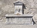
Fountain by the abbey church

Miramont Castle

Half-timbered house

Wayside cross at the chapel

View of Saint Savin

View of the village and the abbey church


.JPG)
.JPG)
_ch%C3%A2teau_Miramont.JPG)
_colombages.JPG)
_croix_mission_%C3%A0_c%C3%B4t%C3%A9_chapelle_Pietat.JPG)
_2.jpg)
_abbaye.JPG)
literature
The majority of the novel I sat on the banks of the Rio Piedra and wept by Paulo Coelho , set in the town of Saint-Savin and its surroundings.
Individual evidence
- ↑ short description (French)
- ↑ short description (French)
- ↑ short description (French)
- ↑ Paulo Coelho: On the bank of the Rio Piedra I sat and cried. Translated from the Brazilian by Maralde Meyer-Minnemann . Diogenes, Zurich 1997.