
Betpouey
|
Betpouey Bèthpuei |
||
|---|---|---|
.svg)
|
|
|
| region | Occitania | |
| Department | Hautes-Pyrénées | |
| Arrondissement | Argelès-Gazost | |
| Canton | La Vallée des Gaves | |
| Community association | Pyrénées Vallées des Gaves | |
| Coordinates | 42 ° 53 ' N , 0 ° 2' E | |
| height | 899-2,854 m | |
| surface | 16.20 km 2 | |
| Residents | 87 (January 1, 2017) | |
| Population density | 5 inhabitants / km 2 | |
| Post Code | 65120 | |
| INSEE code | 65089 | |

Betpouey ( Gascon Bèthpuei ) is a French municipality with 87 inhabitants (at January 1, 2017) in the department of Hautes-Pyrénées in the region Okzitanien ; it belongs to the Argelès-Gazost arrondissement and the canton of La Vallée des Gaves .
location
Betpouey is located in the south of the Hautes-Pyrénées department, around 39 km (as the crow flies) south of Tarbes . The place is located on the northern slope of the mountain Mont Agut (2163 m above sea level. M.) near the river Bastan and also in the Pyrenees National Park . It is part of the Lavedan region and its sub-region Vallée de Barège . The highest point of the municipality is the mountain peak of the Pic de la Coume de l'Ours (2854 m above sea level) in the very southeast of the municipality.
The community consists of the village Betpouey and numerous individual farms.
history
In the early Middle Ages the rulership changed frequently (Visigoths, Basques, Franks, Saracens). After that, the place was under the rule of the Kingdom of Aquitaine and the Duchy of Gascony for centuries. From 900 to 1609 there was a county of Bigorre within the aforementioned areas. A sub-area of this rule was the Lavedan region , which Betpouey was part of. During the Hundred Years War Betpouey was sometimes under English, sometimes under French rule. From 1425 to 1609 the place belonged as part of the county of Bigorre to the county of Foix, which is only loosely connected to France . Because the last ruler of this county, King Henry II of the House of Bourbon, ascended the throne of France (as Henry IV) in 1589, the places in the region were crown domains from 1609 to 1789. The municipality belonged to the District of Argelès from 1793 to 1801. It was also part of the canton of Luz-Saint-Sauveur from 1793 to 2015 (1793–1962 under the name of Canton Luz ). With the exception of the years 1926 to 1942 (Arrondissement Bagnères) Betpouey was administratively part of the Arrondissement Argelès-Gazost since 1801. First mentioned by name as De Bet Puey and Bed Pui in the Bigorre copial book in the 12th century.
Population development
| year | 1793 | 1806 | 1821 | 1831 | 1841 | 1896 | 1962 | 1968 | 1975 | 1982 | 1990 | 1999 | 2006 | 2012 |
| Residents | 533 | 587 | 580 | 537 | 564 | 502 | 218 | 204 | 159 | 147 | 141 | 128 | 112 | 118 |
| Sources: Cassini and INSEE | ||||||||||||||
In the 19th century the place always had over 500 inhabitants. The increasing mechanization of agriculture led to a continuous decline in the number of inhabitants to the lows of recent times.
Attractions
- Romanesque village church of Saint-Sébastien (12th-14th centuries)
- numerous old houses
- Lavoir in the village center

Mairie (Town Hall) of Betpouey
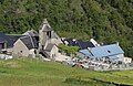
Saint-Sébastien village church

View of Betpouey
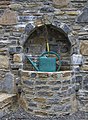
Well in the cemetery
Statue of Notre Dame de la Batsus

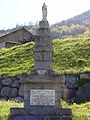
Memorial to the Fallen

_1.jpg)
_1.jpg)


