
Saligos
|
Saligos Saligòs |
||
|---|---|---|
.svg)
|
|
|
| region | Occitania | |
| Department | Hautes-Pyrénées | |
| Arrondissement | Argelès-Gazost | |
| Canton | La Vallée des Gaves | |
| Community association | Pyrénées Vallées des Gaves | |
| Coordinates | 42 ° 54 ' N , 0 ° 1' E | |
| height | 596-2,390 m | |
| surface | 7.07 km 2 | |
| Residents | 107 (January 1, 2017) | |
| Population density | 15 inhabitants / km 2 | |
| Post Code | 65120 | |
| INSEE code | 65399 | |

Saligos ( Gascon SALIGOS ) is a French municipality with 107 inhabitants (at January 1, 2017) in the department of Hautes-Pyrénées in the region Okzitanien ; it belongs to the Argelès-Gazost arrondissement and the canton of La Vallée des Gaves .
location
Saligos is located in the south of the Hautes-Pyrénées department, around 39 km (as the crow flies) south-southwest of Tarbes . The place is located on the western slope of the Soum de Nère mountain (2390 m above sea level) east of the Gave de Gavarnie river in the Pyrenees National Park .
The community consists of the villages of Saligos and Vizos, two campsites on the river, some small settlements and individual farmsteads.
history
In the early Middle Ages the rulership changed frequently (Visigoths, Basques, Franks, Saracens). After that, the place was under the rule of the Kingdom of Aquitaine and the Duchy of Gascony for centuries. From 900 to 1609 there was a county of Bigorre within the aforementioned areas. During the Hundred Years War Saligos was sometimes under English, sometimes under French rule. From 1425 to 1609 the place belonged as part of the county of Bigorre to the county of Foix, which is only loosely connected to France . Because the last ruler of this county, King Henry II of the House of Bourbon, ascended the throne of France (as Henry IV) in 1589, the places in the region were crown domains from 1609 to 1789. The municipality belonged to the District of Argelès from 1793 to 1801. It was also part of the canton of Luz-Saint-Sauveur from 1793 to 2015 (1793–1962 under the name of Canton Luz ). With the exception of the years 1926 to 1942 (Arrondissement Bagnères), Saligos was administratively part of the Arrondissement Argelès-Gazost since 1801. First mentioned by name as Saligos in the Bigorre copial book in the 12th century.
On January 1, 2017, the municipality of Vizos was incorporated.
Population distribution and extrapolation
| District | former INSEE code |
Area (km²) |
Altitude (m) | Population (Census) | ||||||||||||
|---|---|---|---|---|---|---|---|---|---|---|---|---|---|---|---|---|
| 1851 | 1901 | 1954 | 1962 | 1968 | 1975 | 1982 | 1990 | 1999 | 2006 1 | 2008 2 | 2011 3 | 2013 2 | ||||
| Saligos | 65399 | 4.51 | 596-2390 | 273 | 247 | 121 | 109 | 99 | 91 | 82 | 84 | 80 | 85 | 82 | 83 | 90 |
| Vizos | 65480 | 2.56 | 705-2163 | 101 | 84 | 54 | 64 | 55 | 44 | 43 | 37 | 33 | 29 | 35 | 41 | 38 |
| Saligos | 65399 | 7.07 | 596-2390 | 374 | 331 | 175 | 173 | 154 | 135 | 125 | 121 | 113 | 114 | 117 | 134 | 128 |
In the 19th century the place had mostly over 200 inhabitants. The increasing mechanization of agriculture led to a continuous decline in the number of inhabitants to the lows of recent times.
Attractions
- Saint-Pierre village church from the 12th century
- Wegkreuz Croix de Gardette north of the village
- Lavoir (wash house)

Mairie (Town Hall) of Saligos

Aerial view of Vizos

Saint-Pierre village church

Bell tower of the Saint-Pierre church
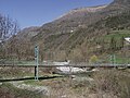
Passerelle over the Gave de Gavarnie

The mayor's office in Vizos

_1.jpg)
.JPG)

.JPG)
_1.jpg)
Web links
- Location of the municipality
- Brief information about the community
- Saligos on the side of the IGN
- Saint-Pierrel church
- Photos of the Saint-Pierre village church