
Lau-Balagnas
|
Lau-Balagnas Laurs e Balanhans |
||
|---|---|---|
.svg)
|
|
|
| region | Occitania | |
| Department | Hautes-Pyrénées | |
| Arrondissement | Argelès-Gazost | |
| Canton | La Vallée des Gaves | |
| Community association | Pyrénées Vallées des Gaves | |
| Coordinates | 43 ° 0 ′ N , 0 ° 5 ′ E | |
| height | 419-573 m | |
| surface | 2.90 km 2 | |
| Residents | 524 (January 1, 2017) | |
| Population density | 181 inhabitants / km 2 | |
| Post Code | 65400 | |
| INSEE code | 65267 | |

Lau-Balagnas ( Gascon Laurs e Balan Hans ) is a French municipality with 524 inhabitants (at January 1, 2017) in the department of Hautes-Pyrénées in the region Okzitanien ; it belongs to the Argelès-Gazost arrondissement and the canton of La Vallée des Gaves .
location
Lau-Balagnas is located in the south of the Hautes-Pyrénées department, around 30 km (as the crow flies) southwest of Tarbes . The place is west of the river Gave de Gavarnie in the vicinity of the Pyrenees National Park .
The community consists of several settlements, hamlets (hameaux) and individual farmsteads.
history
In the early Middle Ages the rulership changed frequently (Visigoths, Basques, Franks, Saracens). After that, the place was under the rule of the Kingdom of Aquitaine and the Duchy of Gascony for centuries. From 900 to 1609 there was a county of Bigorre within the aforementioned areas. During the Hundred Years War Lau-Balagnas was sometimes under English, sometimes under French rule. From 1425 to 1609 the place belonged as part of the county of Bigorre to the county of Foix, which is only loosely connected to France . Because the last ruler of this county, King Henry II of the House of Bourbon, ascended the throne of France (as Henry IV) in 1589, the places in the region were crown domains from 1609 to 1789. The municipality belonged to the District of Argelès from 1793 to 1801. In addition, it was from 1793 to 1801 part of the canton of Saint-Savin and from 1801 to 2015 part of the canton of Argelès-Gazost (1793-1896 under the name of Canton Argelès ). With the exception of the years 1926 to 1942 (Arrondissement Bagnères), Lau-Balagnas was administratively part of the Arrondissement Argelès-Gazost since 1801. First mention of Lau by name around 1035 and of Balagnas as Balaias in the copial book of Saint-Savin. The municipality is part of the historical Lavedan landscape (also known as the Pays des Sept Vallées ). In 1846 Lau (284 inhabitants) and Balagnas (134 inhabitants) merged to form the new municipality of Lau-Balagnas.
Population development
| year | 1793 | 1806 | 1821 | 1831 | 1836 | 1841 | 1846 | 1876 | 1886 | 1936 | 1962 | 1968 | 1975 | 1982 | 1990 | 1999 | 2006 | 2012 |
| Residents | 287 | 327 | 321 | 387 | 421 | 408 | 418 | 322 | 370 | 266 | 443 | 524 | 607 | 565 | 519 | 483 | 489 | 503 |
| Sources: Cassini and INSEE | ||||||||||||||||||
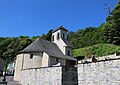
Attractions
- Saint Laurent village church in Lau
- Chapel of Saint Laurent in Balagnas
- Chapel of Sainte-Castêre
- two wayside crosses
Personalities
- François Vignole (1912–1992), ski racer

Saint Laurent village church in Lau
Chapel of Saint Laurent in Balagnas

The Gave d'Azun river with bridge
_1.jpg)
_1.jpg)
