
Aspin-en-Lavedan
| Aspin-en-Lavedan | ||
|---|---|---|
.svg)
|
|
|
| region | Occitania | |
| Department | Hautes-Pyrénées | |
| Arrondissement | Argelès-Gazost | |
| Canton | Lourdes-1 | |
| Community association | Agglomération Tarbes-Lourdes-Pyrénées | |
| Coordinates | 43 ° 5 ′ N , 0 ° 3 ′ W | |
| height | 370-622 m | |
| surface | 1.77 km 2 | |
| Residents | 334 (January 1, 2017) | |
| Population density | 189 inhabitants / km 2 | |
| Post Code | 65100 | |
| INSEE code | 65040 | |
_1.jpg) View of the center of Aspin-en-Lavedan |
||

Aspin-en-Lavedan is a French commune with 334 inhabitants (as of January 1, 2017) in the Hautes-Pyrénées department in the Occitanie region (before 2016: Midi-Pyrénées ). The municipality belongs to the arrondissement Argelès-Gazost and the canton Lourdes-1 (until 2015: canton Lourdes-Ouest ).
The inhabitants are called Aspinois and Aspinoises .
geography
Aspin-en-Lavedan is located about two kilometers south of Lourdes in its catchment area ( Aire urbaine ) in the historic province of Bigorre .
Aspin-en-Lavedan is surrounded by the four neighboring communities:
| Lourdes | ||
| Ossen |
.svg)
|
|
| Viger | Lugagnan |
Aspin-en-Lavedan is located in the catchment area of the Adour River on the left bank of the Gave de Pau , a tributary of the Adour. The Ruisseau de Lanusse crosses the area of the municipality and flows into the Gave de Pau.
Toponymy
The Occitan name of the community is Aspin. There are two theories about the origin of the name. As in the community of the same name, Aspin-Aure, it could be derived from the French aubépine or from épine ( German hawthorn or thorn ) or from the Basque and Aquitanian asp ( German rock ), from which many toponyms in the Pyrenees have emerged. The fact that the area was inhabited in earlier times and the simple settlement was on a rocky hill speaks in favor of the latter possibility.
The community's nickname is Eths tavinats ( German for little brakes ), which also applies to the other communities in the Vallée de Batsurguère (Ossen, Ségus , Viger and Omex ).
Toponyms and mentions of Aspin-en-Lavedan were:
- A-Spi (around 1200–1230, copy book of the County of Bigorre),
- l'Abadie d'Aspi (12th or 13th century, copial book of the Viscounts of Lavedan , called Livre vert de Bénac ),
- De Aspino (1313 and 1342, Debita regi Navarre tax register and Tarbes parish register ),
- d'Aspi (1379, Prokuration Tarbes),
- D'Aspii (14th century and 1403, Livre vert de Bénac ),
- Aspi (1429, Bigorre County Census),
- Aspi (1541, ADPA, B 1010),
- Aspin des Angles (1750, map by Cassini ),
- Aspin (1793 and 1801, Notice Communale and Bulletin des lois , respectively ),
- Aspin-en-Lavedan (1962).
Population development
After records began, the population rose to a peak of 240 by the second half of the 19th century. In the following period, the size of the community fell to 115 with brief recovery phases until after the Second World War , before a phase of at times strong growth began continues to this day.
| year | 1962 | 1968 | 1975 | 1982 | 1990 | 1999 | 2006 | 2011 | 2017 |
|---|---|---|---|---|---|---|---|---|---|
| Residents | 185 | 173 | 227 | 257 | 256 | 223 | 234 | 253 | 334 |

Attractions
Parish church de-l'Assomption
The church, consecrated to the Assumption of Mary , has a natural stone masonry on the outside . The previous Romanesque building may have its origins in 672. It was rebuilt in the 18th and 19th centuries. From the previous one. There is not much left of a simple church if it weren't for a 12th century Christ monogram that adorned the tympanum on the lintel above the entrance. It was found while working in the rectory garden , where it had been used as a step before it can now be seen inside the church. A special feature is the combination of alpha and omega with the letter Chi with an arrow. The current building was restored in the last century. The bell tower has three sculptural corbels , one in the shape of an animal, one in the shape of a head. The interior of the church hides a stone, semicircular baptismal font from the 19th century, whose special shape is typical of the area. The chair of the vicar's chair and an oil painting with Mary and free angels in the gallery are from the same period .

Parish church de-l'Assomption

inside view
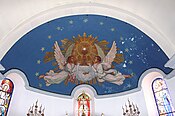
Dome over the choir
_1.jpg)
_3.jpg)
_4.jpg)
Former Saint-Georges chapel
North of the center of Aspin between the Gave and the Ruisseau de Lanusse there is an area full of relics from ancient times. Behind the remains of a former quarry are foundations of the former Yorli or Yorly (Saint George) chapel . Its origin has not been fully clarified. It could be the Christianization of a Roman temple at the time of the Carolingians . The building had a floor plan of 3 mx 7 m with an entrance on the south side. It probably served as a place of worship for the local quarry workers. The hill had been inhabited since early history . Various researchers noticed a forge and traces of an associated house made of light materials, probably from the Iron Age . The 1429 census mentions a fenced plot of land and a lime kiln , of which only the foundations and some walls of the chapel including the base of the altar remain. Near the top is a hand mill Gallo-Roman as well as fragments of a consecration stone of marble found in honor of St. Beatus. Settlement of the hill seems to have lasted until the 16th century. On the way to the Plagnet mill in the field near the bridge over the Ruisseau de Lanusse, Jacques Omnès discovered fragments of ancient amphorae and ceramics . In 2013, an independent researcher found three Celtiberian silver coins and one gold coin from the time of the French King Charles V in surrounding fields .
Economy and Infrastructure

Aspin-en-Lavedan is located in the AOC zones of the Porc noir de Bigorre pig breed and the Jambon noir de Bigorre ham .

total = 87
sport and freetime
The GR 101, a long-distance hiking trail from Maubourguet to the Col de Saucède, crosses the territory of the municipality.
traffic
Aspin-en-Lavedan can be reached via Routes départementales 13, 821, the former Route nationale 21 , and 921B.
Web links
Individual evidence
- ↑ Hautes-Pyrénées ( fr ) habitants.fr. Retrieved September 27, 2019.
- ↑ Aire urbaine de Lourdes (242) ( fr ) INSEE . Retrieved September 27, 2019.
- ↑ Ma commune: Aspin-en-Lavedan ( fr ) Système d'Information sur l'Eau du Bassin Adour Garonne. Retrieved September 28, 2019.
- ↑ Aspin-en-Lavedan ( fr ) Hautes-Pyrénées department. Retrieved September 28, 2019.
- ^ David Rumsey Historical Map Collection France 1750 ( en ) David Rumsey Map Collection: Cartography Associates. Retrieved September 28, 2019.
- ↑ a b Notice Communale Aspin-en-Lavedan ( fr ) EHESS . Retrieved September 28, 2019.
- ↑ Populations légales 2016 Commune d'Aspin-en-Lavedan (65040) ( fr ) INSEE . Retrieved September 27, 2019.
- ↑ a b ASPIN- EN- LAVEDAN (Aspin) ( fr ) Patrimoines Lourdes Gavarnie. Retrieved September 28, 2019.
- ↑ Aspin-en-Lavedan ( fr ) Lavedan 65. Retrieved September 28, 2019.
- ↑ Institut national de l'origine et de la qualité: Rechercher un produit ( fr ) Institut national de l'origine et de la qualité . Retrieved September 27, 2019.
- ↑ Caractéristiques des établissements en 2015 Commune d'Aspin-en-Lavedan (65040) ( fr ) INSEE . Retrieved September 27, 2019.
- ↑ GR101 - Randonnée de Maubourguet au Col de Saucède (Hautes-Pyrénées) ( fr ) gr-infos.com. Retrieved September 28, 2019.