
Agos-Vidalos
|
Agos-Vidalos Agòs e Vidalòs |
||
|---|---|---|
.svg)
|
|
|
| region | Occitania | |
| Department | Hautes-Pyrénées | |
| Arrondissement | Argelès-Gazost | |
| Canton | La Vallée des Gaves | |
| Community association | Pyrénées Vallées des Gaves | |
| Coordinates | 43 ° 2 ′ N , 0 ° 4 ′ E | |
| height | 391-1,360 m | |
| surface | 6.11 km 2 | |
| Residents | 416 (January 1, 2017) | |
| Population density | 68 inhabitants / km 2 | |
| Post Code | 65400 | |
| INSEE code | 65004 | |

Agos-Vidalos ( Gaskognisch Agòs e Vidalòs ) is a French commune with 416 inhabitants (as of January 1, 2017) in the Hautes-Pyrénées department in the Occitania region ; it belongs to the Argelès-Gazost arrondissement and the canton of La Vallée des Gaves . The inhabitants call themselves Agolosiens / Agolosiennes .
location
Agos-Vidalos is located in the southwest of the Hautes-Pyrénées department, around 25 km (as the crow flies) southwest of Tarbes . The river Gave de Pau crosses the municipality and in parts forms the eastern border of the municipality. The highest point in the municipality is the Pic de Boun mountain in the northwest of the municipality. Large parts of the municipality are forested.
The community consists of the villages Agos (consists of Marque debat and Marque dessus) and Vidalos and a few individual farms.
Neighboring communities are Ossen in the north-west, Viger in the north and north-east, Ger in the north-east, Geu in the east, Boô-Silhen in the south-east and south, Ayzac-east in the south-west and west, and Ouzous in the north-west.
history
In the early Middle Ages the rulership changed frequently (Visigoths, Basques, Franks, Saracens). After that, the place was under the rule of the Kingdom of Aquitaine and the Duchy of Gascony for centuries. From 900 to 1609 there was a county of Bigorre within the aforementioned areas. During the Hundred Years War , Arras-en-Lavedan was sometimes under English, sometimes under French rule. From 1425 to 1609 the place belonged as part of the county of Bigorre to the county of Foix, which is only loosely connected to France . Because the last ruler of this county, King Henry III. of Navarre from the House of Bourbon, in 1589 ascended the throne of France (as Henry IV.), the places in the region were crown domains from 1609 to 1789. The municipality belonged to the District of Argelès from 1793 to 1801. It was also part of the canton of Argelès-Gazost from 1793 to 2015 . With the exception of the years 1926 to 1942 (Arrondissement Bagnères), Agos-Vidalos was administratively part of the Arrondissement Argelès-Gazost from 1801. First indirect mention of Agos by name as a Raimundo de Gos appears in the Green Book of Bénac around 1040. Vidalos is first mentioned as Bidalos in the year 1184 in Bigorre's copial book . The municipality is part of the historical Lavedan landscape (also known as the Pays des Sept Vallées ). In 1846 the municipalities of Agos (1846: 238 inhabitants) and Vidalos (1846: 120 inhabitants) merged to form today's municipality.
Population development
| year | 1962 | 1968 | 1975 | 1982 | 1990 | 1999 | 2006 | 2016 | |||||||||||||
| Residents | 256 | 265 | 285 | 272 | 270 | 290 | 350 | 425 | |||||||||||||
| Sources: Cassini and INSEE; today's municipal area | |||||||||||||||||||||
The number of residents has declined since 1793 due to emigration, the fallen in World War I and the flu wave of 1918/1919. The lowest population figures come from the interwar period.
Attractions
- Village church of Saint-Michel in Vidalos
- Village church of Saint-Hippolyte in Marque dessus (Agos)
- Castle tower from 1175 in Vidalos
- numerous older buildings
- several village wells
- Lavoirs (wash houses) in Agos and Vidalos
- Town hall (Mairie) with old village school
- Crossroads Croix du Turon de Fontaine and Croix du Turonet de Pujo
- Memorial to the Fallen

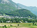
View of Agos
View of Vidalos

Saint-Hippolyte village church in Agos

Village church of Saint-Michel in Vidalos

Tower of Vidalos
.JPG)
.JPG)
.jpg)
_1.jpg)

Web links
- Brief information about the community
- Agos-Vidalos on the IGN side
- Photos of the two village churches