
Estaing (Hautes-Pyrénées)
| Estaing | ||
|---|---|---|
.svg)
|
|
|
| region | Occitania | |
| Department | Hautes-Pyrénées | |
| Arrondissement | Argelès-Gazost | |
| Canton | La Vallée des Gaves | |
| Community association | Pyrénées Vallées des Gaves | |
| Coordinates | 42 ° 56 ′ N , 0 ° 11 ′ W | |
| height | 906-2,960 m | |
| surface | 71.53 km 2 | |
| Residents | 83 (January 1, 2017) | |
| Population density | 1 inhabitant / km 2 | |
| Post Code | 65400 | |
| INSEE code | 65169 | |
_1.jpg) Mayor's office ( Mairie ) of Estaing |
||

Estaing is a French commune with 83 inhabitants (as of January 1, 2017) in the Hautes-Pyrénées department in the Occitanie region (before 2016: Midi-Pyrénées ). The municipality belongs to the arrondissement of Argelès-Gazost and the canton of La Vallée des Gaves (until 2015: canton of Aucun ).
The inhabitants are called Estaingeois and Estaingeoises .
geography
Estaing is about ten kilometers southwest of Argelès-Gazost in the historic Bigorre province . The municipality borders on the autonomous community of Aragon in northern Spain to the south . The southern part of the municipality is part of the Pyrenees National Park .
Estaing is surrounded by the seven neighboring communities:
| Aucun |
Bun Sireix |
Arras-en-Lavedan |
| Arrens-Marsous |
.svg)
|
Cauterets |
|
Sallent de Gállego (Spain) |

The highest point of the municipality is on the summit of the Pic de Cambalès ( 2965 m ).
_1.jpg)
Estaing lies in the catchment area of the Adour River .
The Gave d'Estaing, also known as the Gave de Labat de Bun on its upper reaches, is a tributary of the Gave d'Azun and has its source in Estaing. Its tributaries cross the territory of the municipality:
- the Ruisseau du Pic Arrouy,
- the Ruisseau de Malh Ardoun,
- the Ruisseau de Garren Blanc,
- the Ruisseau de Coudé,
- the Ruisseau de Bayelle,
- the Ruisseau d'Aumède,
- the Ruisseau de Cradey,
- the Ruisseau de Laur,
- the Ruisseau des Boussus,
- the Ruisseau de Bergouey,
- the Ruisseau Hadernes and
- the Ruisseau de Larrode.
The Gave de Cauterets , a tributary of the Gave de Pau , also irrigates the municipality along with its tributaries,
- the Gave de Cambalès with its tributary,
- the Ruisseau de Bassia,
- the Ruisseau du Pourtet and
- the Gave de Cambasque with its tributary,
- the Ruisseau d'Ilhéou.
history
The municipality was founded in 1836 on the basis of parts of the municipal areas of Aucun and Bun (Labat d'Aucun and Labat de Bun).
Population development
When the municipality was founded, the number of inhabitants reached its highest level of around 440. In the period that followed, the size of the municipality fell to around 65 inhabitants with short recovery phases by the turn of the millennium, before a phase of moderate growth began, which continues today.
| year | 1962 | 1968 | 1975 | 1982 | 1990 | 1999 | 2006 | 2011 | 2017 |
|---|---|---|---|---|---|---|---|---|---|
| Residents | 153 | 122 | 101 | 91 | 86 | 67 | 73 | 76 | 83 |

Attractions
- Parish Church of Saint-Jean-Baptiste

Parish Church of Saint-Jean-Baptiste
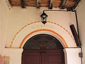
entrance
_2.jpg)

Economy and Infrastructure

Estaing is located in the AOC zones of the Porc noir de Bigorre pig breed and the Jambon noir de Bigorre ham .

Total = 23
sport and freetime
The GR 10 , a GR long-distance hiking trail from Hendaye to Banyuls-sur-Mer , runs through the center of the municipality.
The GR de Pays Tour du Val d'Azun long-distance hiking trail also leads through the center of Estaing.
traffic
Estaing can be reached via Route départementale 103, which ends here near Lac d'Estaing.
Web links
Individual evidence
- ↑ Hautes-Pyrénées ( fr ) habitants.fr. Retrieved November 13, 2019.
- ↑ Ma commune: Estaing ( fr ) Système d'Information sur l'Eau du Bassin Adour Garonne. Retrieved November 13, 2019.
- ↑ a b Notice Communale Estaing ( fr ) EHESS . Retrieved November 13, 2019.
- ↑ Populations légales 2016 Commune d'Estaing (65169) ( fr ) INSEE . Retrieved November 13, 2019.
- ↑ Institut national de l'origine et de la qualité: Rechercher un produit ( fr ) Institut national de l'origine et de la qualité . Retrieved November 13, 2019.
- ↑ Caractéristiques des établissements en 2015 Commune d'Estaing (65169) ( fr ) INSEE . Retrieved November 13, 2019.
- ^ La Grande Traversée des Pyrénées ( fr ) Association Les Amis GRdistes. Retrieved November 13, 2019.
- ↑ GRP Val d'Azun ( fr ) Fédération française de la randonnée pédestre (FFRandonnée / FFRP). Retrieved November 13, 2019.