Sośnica (Gliwice)
| Gliwice-Sośnica Gleiwitz-Sosnitza |
||
|---|---|---|
 Help on coat of arms |
|
|
| Basic data | ||
| State : | Poland | |
| Voivodeship : | Silesia | |
| Powiat : | District-free city | |
| District of: | Gliwice | |
| Geographic location : | 50 ° 17 ' N , 18 ° 44' E | |
| Residents : | ||
| Postal code : | 44-103, 44-119 | |
| Telephone code : | (+48) 032 | |
| License plate : | SG | |
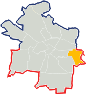
Sośnica (German: Sosnitza , also Sossnitza ) is a district of Gliwice (Gleiwitz). Sośnica is located in the east of Gliwice on the city border with Zabrze (Hindenburg OS). About 18,000 people live in Sośnica. The Klodnitz runs through the district .
history

The place originated in the 13th century at the latest and was first mentioned in a document in 1260.
The place was in 1783 in the book Beyträge to describe Silesia as Sosni (t) ze and Schosni (t) z mentioned owned was a gentleman of Wilczek, was in the district of Bytom of Standesherrschaft Bytom and had a Vorwerk, 159 inhabitants, 19 farmers , eleven gardeners, 18 cottagers and a mill. In 1818 the place was mentioned as Schosnitz . In 1847 the Catholic school was built. Before that, the place in Alt-Zabrze was schooled. In addition, since there was no church on site, the residents were parish in Alt-Zabrze . In 1865 Soßnitza consisted of a Dominial-Terrain and a municipality. At that time the village community had four farms, 32 half-farmers, 25 gardeners and 52 cottagers. The school had 183 students. The estate belonged to Count Guido Henckel von Donnersmarck zu Neudeck. In 1873 the district of Beuthen was divided and the place came to the new district Zabrze (the later district Hindenburg OS).
In 1911 an auxiliary church was built, which was replaced by the Maria-Hilf-Kirche in 1929. In the referendum in Upper Silesia on March 20, 1921, 1058 eligible voters voted for Upper Silesia to remain with Germany and 1563 for membership of Poland. After the partition of Upper Silesia, Sosnitza remained with the German Empire . On January 1, 1927, Sosnitza was incorporated into Gleiwitz by the disbanded district of Hindenburg OS . In 1936, the city in the wake of a wave of local renaming was the Nazi period with reference to the Oehringen pit in Oehringen renamed.
In 1945 the previously German town came under Polish administration and was then joined to the Silesian Voivodeship and renamed Sośnica in Poland . In 1950 the place came to the Katowice Voivodeship . In 1999 the place became part of the new Silesian Voivodeship.
Buildings and sights
- The Hyacinth Church, a modern Catholic church that was built from 1998 to 2003.
- The Mary Help of Christians Church , a Catholic church built in 1929 in a contemporary style with a bell tower.
- A wayside shrine
education
- Elementary School No. 14
- Primary School No. 15
- Elementary School No. 21
- Gymnasium No. 6
- Niepubliczne Liceum Ogólnokształcące Szkoła Mistrzostwa Sportowego
- Liceum Ogólnokształcące number 10
- Zespół Szkół Ekonomiczno – Technicznych
Personalities
- Włodzimierz Lubański (* 1947), former Polish football player
- Lukas Podolski (* 1985), the soccer player, grew up in the district from June 1985.
- Gerhard Schwedka (1913–1988), German politician (SPD / SED) and trade unionist, chairman of the central committee of the textile, clothing and leather industrial union in the FDGB
- Joseph Wloka (* 1929), German mathematician who dealt with functional analysis
traffic
The A4 and A1 motorways run near Sośnica . In addition, the Katowice Ligota – Gliwice railway runs on site .
Web links
Individual evidence
- ^ Johann Ernst Tramp: Additions to the Description of Silesia, Volume 2 , Brieg 1783
- ^ Geographical-statistical handbook on Silesia and the county of Glatz, Volume 2 , 1818
- ^ Johann G. Knie: Alphabetical-statistical-topographical overview of the villages, spots, cities and other places of the royal family. prussia. Province of Silesia . Grass, Barth, 1845 ( google.de ).
- ↑ Felix Triest: Topographisches Handbuch von Oberschlesien , Breslau 1865
- ^ Results of the referendum in Upper Silesia in 1921: Literature , table in digital form
- ↑ MDR-INFO (radio) from October 11, 2014


