
Locking point on the Lining plain

The lock point on the Linth plain or the Linth position was a defensive position of the Swiss Army . It is located at the former entrance to the Reduite in the Linth plain in the cantons of Schwyz , St. Gallen and Glarus . The line position of the 7th Division was heavily fortified from October 1939 to June 1942. In 1947 she was assigned to the Reduit Brigade 24 , and in 1978 she moved to the 6th Division of Field Army Corps 4 .
The Grinau and Reichenburg-Buttikon barriers , the main bases of the defense front in the Linth plain, are considered to be military-historical monuments of national importance.
history
The Linthebene was a preferred axis of incidence of the German operation plans for mechanized associations and airborne troops, because they access into the basin of Schwyz and direction Gotthard enabled and the entrance to the Glarnerland and the three Alpine passes Pragel , Klausen and Kistenpass formed. It played an important role in the army's defense system as part of the Limmat position and from July 1940 as the northern border / presentation of the Reduit front , which had to be held to the utmost .
This important strategic importance was recognized even before the outbreak of war and studies were carried out on a possible flooding in order to prevent tank advances and tactical air landings in the Linth plain. On October 30, 1939, General Guisan ordered the construction of the dams immediately and approved a loan of 200,000 francs for flood preparations. At the beginning of 1940 the Swiss Army was partially restructured and a 4th Army Corps was created. The 7th Division, subordinated to the 4th Army Corps, took up the Linth position under its commander Hermann Flückiger in September 1939 with around 13,000 men (infantry regiments 31, 33, 34, 85). In May 1940 the general ordered the construction of 20 infantry plants, including infantry and tank obstacles, along the Linth Canal, four of which had armored domes for artillery observation.
The 7th Division had three defensive fronts / combat groups: the right one ran from Federispitz via Schänis-Unter Bilten to Sunnenberg, the middle one from Unter Bilten to Reichenburg with a base on the Benkner Büchel and the left one from Reichenburg along the railway line to Buttikon from there to Tuggen and ended at the Grynau. The artillery positions were in the Niederurnen and Holeneich-Lachen area.
On July 25, 1940, on the occasion of the Rütli report , General Guisan informed all senior officers of the plan to concentrate the defense of Switzerland on the new central position of the Reduit and, if necessary, to destroy all approaches to the mountains in the event of an attack by the Axis powers. The 7th Division remained in the Linth position as it was included in the army's new central position. The construction work stopped on the Limmat line in June 1940 was resumed on the Linth position in July 1940.
In August 1940 the 7th Division received the order to hold the central position in the Reichenburg-Grynau-Buechberg-Obersee-Etzel section with main bases in the Linth area and on the Etzel and to prevent an enemy push into the Wägi-, Sihl- and Alpthal. For this purpose, the main combat groups Linth, Lachen, Etzel and the combat detachment Wägital were formed. For them, the rock works Grynau and Benkner Büchel, the artillery works in Oberurnen and at the beginning of Wägital, the widening and deepening of the canals on both sides of the Linth (Lake Zurich to Grynau) as additional tank obstacles as well as explosive objects at the Linth bridges, at Seedamm, Teufelsbrücke and Wägital.
With the new operational order of the 4th Army Corps of January 1941, the 7th Division's disposition was adapted from a linear defensive battle to a deeply staggered defensive battle (from the Linth level) by regrouping the front and moving it back to the Rinderweidhorn-Stöcklikreuz-Etzel ridges. The new combat groups "Bataillon Linth" (blocked position behind the Linth, Linthstauanlagen), "Pfiffegg" (access to Wägital), "Oberegg" (access to the Sihlsee area), "Etzel" (Etzel crossing) were formed, and the 34th Infantry Regiment was designated as a division reserve. The artillery (field artillery departments 19 and 21) was in the Sihlsee area. Since the German plans of attack provided for the rapid occupation of the Reduite entrances by airborne troops, the general had these permanently secured by strong units, which were mobilized through "silent" mobilization using marching order cards.
The fortifications continued to be used in the post-war years and were equipped with newer types of weapons.
Lock point Grynau
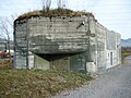
The Grynau-Tuggen barrier (Army designation no. 2424) was a key area in the Buechberg base of the 7th Division's Linth position during World War II . In addition to the Linth dam, this had to occupy the two bridgeheads and infantry fortresses Grynau and Möslifluh near Benkner Büchel as well as numerous tank barriers and bunkers along the Linth.
The Buechberg base (Füs Bat 74) and the Tuggen barrier (Füs Bat 73) were heavily fortified from October 1939 to June 1940 and formed the left pillar of the 7th Division's line of defense. After its completion, the Grynau fortress was a major obstacle in connection with the planned flooding of the Lin plain.
Grynau infantry fortress
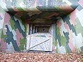
Construction of the Grynau A 6913 infantry fortress began in March 1940. In late summer 1942 it was taken over by the Ter Bat 146 and the Ter Bat Füs Kp II / 146. The work formed the left pillar of the advanced position on the northern edge of the Reduit Dispositiv of the 7th Division. For its use for the Reduit Brigade 24, the Ter Bat 146 became the Füs Bat 146. This continued to provide the factory crew until the change from the Lin Plain area to Field Army Corps 4 in 1978. The fortress consists of six machine gun bunkers, a bunker for a 4.7 cm infantry cannon and an artillery observation tower, all of which are connected underground by corridors. The bunkers are located near Grynau Castle along the hiking trail that leads from the castle over the Buechberg to Nuolen and Lachen . The white signs on the bunker hiking trail show the way to the bunkers.
At the end of the 1960s, the fortress was modernized with a 9 cm anti-tank gun 50 and six machine guns 51. It was disarmed in the 1980s.
- Mühlehalden infantry bunker (dismantled) A 6884
- Artillery observer Tuggenegg A 6885
- Artillery observer Tuggenegg A 6886
- Artillery observer Tuggenegg A 6887
- Artillery observer Tuggenegg A 6888
- Artillery observer Tuggenegg A 6889
- Tuggen-Dorf infantry bunker A 6890
- Linthport Infantry Bunker 31/24 A 6891
- Linthport infantry bunker 31/23 A 6892 ⊙
- Linthport infantry bunker 31/22 A 6893 ⊙
- Linthport infantry bunker 31/21 A 6894 ⊙
- Linthport infantry bunker 31/20 A 6895 ⊙
- Infantry bunker Chipf 1 A 6896
- Infantry bunker Chipf 2 A 6897
- Infantry bunker church A 6898
- Infantry bunker Linth 25 A 6911 ⊙
- Linth Infantry Bunker 26 A 6912 ⊙
- Infantry factory Grynau A 6913 ⊙
Infantry plant Grynau A 6913: Mg 20

Infantry plant Grynau A 6913: Mg 17

Infantry factory Grynau A 6913: observer

Infanteriewerk Grynau A 6913: Infantry cannon 19


- Infantry bunker Linthkanal 27 A 6914 ⊙
- Linth Canal 28 Infantry Bunker A 6915 ⊙
- Linth Canal 29 Infantry Bunker A 6916 ⊙
Linth Canal 27 Infantry Bunker A 6914

Linth Canal 28 Infantry Bunker A 6915

Linth Canal 29 Infantry Bunker A 6916

Grynau, shelter “Zug Ghetta” A 6925


- Buchberg A 6923 shelter ⊙
- Infantry bunker A 6924 ⊙
- "Zug Ghetta" shelter A 6925 ⊙
- "Tonhalle" shelter A 6926 ⊙
- Buchberg infantry bunker 2 A 6930 ⊙
- Artillery observer «Hundsruggen» Buchberg 3 A 6931 ⊙
- Infantry bunker Buchberg 4 A 6932 ⊙
- Infantry bunker Buchberg 5 A 6933 ⊙
- Buchberg infantry bunker 6 A 6934 ⊙
- Infantry bunker Buchberg 7 A 6935 ⊙
- Infantry bunker Buchberg 8 A 6936
- Buchberg shelter (medical service) A 6937
- Infantry bunker Buchberg 9 A 6938
- Infantry bunker Buchberg 10 A 6939
- Infantry bunker Buchberg 11 A 3940
- Infantry bunker Buchberg 12 A 3941
- Infantry bunker Buchberg 13 A 3942
- Infantry bunker Buchberg 14 A 3943
- Infantry bunker Buchberg 15 A 3944
- Explosive object Linthbrücke Grynau M 2871
- Explosive object side street Grynau-Bätzimatt M 2872
- Barricade Schlösslitürli T 3530
- GPH Linthport-Tuggen T3531
- Barricade Kepellhof T 3531.01
- Barricade pilgrimage route T 3531.02
- Shelter F 14005 ⊙
Lock point Mösli-Benken SZ / SG
At the Mösli-Benken barrier , the Möslifluh A 6903 infantry work on the Benkner Büchel formed the central cornerstone. With its two 4.7 cm infantry cannons and the machine gun, it was supposed to prevent the crossing of the Giessen Bridge, the breakthrough in the direction of Schänis and access to the floodplains on the Lin plain. The infantry cannons acted on the Giessenbrücke and the Möslifluh-Benken tank barrier. The plant, built in 1941–42, had an infrastructure with accommodation, telephone switchboard, kitchen and water reservoir. Two bunkers with light machine guns (Lmg) had been built for close defense, one of which was integrated into the plant.
During World War II it was occupied by the Territorial Fusilier Company I / 146 and by the Fusilier Battalion 146 until the end of 1976. After the plant was ceded to Field Division 6 of Field Army Corps 4, numerous plants were disarmed.
- Henkelgiessen infantry bunker A 6900 ⊙
- Infantry bunker Grindbühl A 6901 ⊙
- Infantry bunker Signal A 6902
- Möslifluh infantry factory (including two Lmg bunkers) A 6903 ⊙
- IW Möslifluh A 6903: Pak notch ⊙
- Infantry factory Möslifluh A 6903: integrated Lmg external bunker 1 ⊙
- Infantry plant Möslifluh A 6903: Lmg external bunker 2 ⊙
- Infantry bunker Mösli A 6904 ⊙
- Small shelter F 14001 ⊙
- Terrain tank obstacle Möslifluh-Benken ⊙
Infantry factory Mösliflue Benkner Büchel A 6903

IW Möslifluh A 6903 external bunker 1

Infantry bunker Mösli A 6904

Terrain tank obstacle Möslifluh-Benken


- Linthdamm infantry bunker A 6905 ⊙
- Infantry bunker Linthkanal 18 A 6906 ⊙
- Linthkanal 19 infantry bunker A 6907 ⊙
- Linthkanal 20 infantry bunker A 6908 ⊙
- Infantry bunker Linthkanal 21 A 6909 ⊙
- Linth Canal 23 Infantry Bunker A 6910 ⊙

Infantry bunker Linthkanal 18 A 6906

Infantry bunker Linthkanal A 6905, 6906, 6907


Reichenburg-Buttikon SZ lock point
The Reichenburg-Buttikon barrier (army designation no. 7660) belonged to the Reichenburg-Giessen barrier (army designation no. 2425) of the Reduit Brigade 24 until 1977. When the Lint Plain was redistributed to field army corps 4, it became part of field division 6. In addition to the armored terrain obstacle, Reichenburg was part of the barrier -Buttikon-Tuggen two infantry factories, which enabled an all-round defense of the Reichenburg base with the two flanking bunkers and a further three Mg bunkers. Between Reichenburg and Buttikon, a hump barrier was built south of the railway line and on the west side of the Rütibach.
The combined infantry and observer station Fels A 6871 with battalion command post was built from 1940. It was created as the southern end of the Giessen-Reichenburg barrier, had two Mg positions and an artillery observer. It had an infrastructure with a cavern (KP rooms), accommodation, kitchen, ventilation room, engine room as well as radio and ammunition niches. It was also the command post of Territorial Battalion 146 after active service, which was incorporated into Reduit Brigade 24. In 1977 the plant was retired.
The infantry factory Burg A 6874 was also referred to as the KK Reichenburg factory because of its location under the Catholic Church . Its infrastructure included three MG stands, a cavern for command posts and accommodation for seven officers and 80 men, kitchen and storage room. It was flanked by two Mg light stands (Bunker Grubenhof and Glanzgarten) and had to block the flooded Lint Plain between the Benkner Büchel and Reichenburg. The work, completed in 1943, was occupied by Ter Bat 146, which was integrated into the Réduit Brigade 24 and renamed the Füs Bat 146. In the 1960s the castle was modernized and the Mg 11 replaced by Mg 51. The plant was retired in the late 1970s.
- Artillery observation bunker Tafleten A 6868 ⊙
- Bethell artillery observation bunker
- Artillery observation bunker Austock A 6870: light measuring post
- Infantry plant Fels A 6871
- Infantry factory Burg A 6874 ⊙
- Infantry bunker Garage A 6876
- Infantry bunker Bahnhof A 6877: mobile armament
- Grubenhof infantry bunker: IW Burg flanking
- Glanzgarten infantry bunker: Flanking IW Burg
- Infantry bunker chalet
- Infantry bunker Burg (under the church) ⊙
- Infantry bunker Nüguet Ost A 6882 ⊙
- GPH Reichenburg-Tuggen ⊙ ⊙

Infantry factory Burg A 6874

IW Burg entrance to the upper gallery

IW Castle Schartenmauer Süd

IW Castle A6874 Mg West


Blocking point Bilten GL
The blocking point Bilten (Army designation no. 2420) changed in 1977 from Reduit Brigade 24 to Field Division 6. From 1977 onwards the facility was no longer used.
- Infantry bunker Obere Rote Brücke A 6840 ⊙
- Infantry bunker Lower Red Bridge A 6853 ⊙
- Permanent weapon position infantry A 6854 ⊙
- Permanent weapon position infantry A 6855 ⊙
- Permanent weapon position infantry A 6856 ⊙
- Infantry bunker Unterdorf A 6857 ⊙
- Infantry bunker Dörfli A 6858
- Infantry bunker Holdern A 6859
- Spatz A 6860 infantry factory

Upper Red Bridge A 6840

GPH Bilten T 3515 Biltnerbach


- Explosive object bridge Linth Canal Bilten-Schänis M 2873
- GPH Bilten T 3515 ⊙ ⊙
- Barricade Aegertenstrasse T 3515.01
- Barricade Hauptstrasse T 3515.02
- Barricade Unterilten T 3515.03
- Barricade Neue Schandenstrasse T 3515.04

- Barricade mill T 3515.05
- Barricade dirt road T 3515.06
- Barricade dirt road T 3515.07
- Barricade Seggenstrasse T 3515.08
- Barricade Bilten-Unterbilten T 3515.09
- Barricade dirt road T 3515.10
- Barricade dirt road T 3515.11
- Barricade mill T 3515.12
Flooding of the Lin plain
The flooding of the Lin plain ( inundation , French inondation) was part of the military defense line of the Swiss Army in World War II against an enemy incursion from the north. The planned flooding and swamping would have created the medieval Tuggenersee between Uznach , Giessen, Schübelbach and Tuggen as well as three smaller lakes between Benken-Giessen and Schänis . The 7th Division was responsible for guarding and defending the dams.
Schwyz Fortress Foundation

The Schwyzer Festungswerke Foundation is a foundation with the purpose of safeguarding and maintaining the military-historical legacy of the Swiss Confederation in the Canton of Schwyz. She has taken over fortifications from the Canton of Schwyz, which she maintains and shows on guided tours.
Eco-Museum fortress works in Upper Buchberg
The “Oberer Buchberg Fortress Works” eco-museum comprises nine historical combat structures from 1939 and 1940/41. The defense system with stagnation sites to flood the Linth plain, with tank ditches, anti-tank barriers, bunkers and a large rock structure has been preserved as a whole.
During the Cold War until 1990, the main plant in Mösliflue A 8903 housed the army's material warehouse for the resistance regions of Eastern Switzerland under the code name “ZL Burg”. The "Musée résistance suisse 1940" on the Linth has been located here since 2009 and is dedicated to secret resistance preparations in the event of an enemy occupation. The 50-year history of the resistance is told on 24 boards and in documentary films.
literature
- Valentin Kessler: The fortifications in the canton of Schwyz . Reprint from the communications of the Historical Association of the Canton Schwyz, issue 95, 2003.
- Silvio Keller, Maurice Lovisa, Thomas Bitterli: Military monuments in the cantons of Uri, Schwyz and Zug. Inventory of combat and command structures , Federal Department of Defense, Civil Protection and Sport (ed.), Bern 2005.
Web links
- Website of the Schwyzer Fortress Works Foundation
- Bunker friends: facilities Buchberg, Grynau SZ
- Oberland Fortress: Grynau / Tuggen restricted area
Individual evidence
- ↑ Restrictions Grinau and Reichenburg-Buttikon. In: Silvio Keller, Maurice Lovisa, Thomas Bitterli: Military monuments in the cantons of Uri, Schwyz and Zug. Inventory of the combat and command structures. , Pages 26–29, Ed .: Federal Department of Defense, Civil Protection and Sport, Bern 2005 (PDF; 2.1 MB)
- ^ Gotthard Frick: Hitler's War and the Self-Assertion of Switzerland 1933–1945 . Self-published, Bottmingen 2011, ISBN 978-3-033-02948-4 .
- ↑ Little porcupine: Barrier to Grynau Infantry Works, SZ
- ↑ Little porcupine: Locking point on the Lint level SZ / SG
- ↑ Oberland Fortress: Mösli / Benken SZ / SG locking point
- ↑ Fortress Oberland: Reichenburg Lock Point SZ
- ↑ Small porcupine: Reichenburg lock SZ
- ^ Upper Buchberg fortifications: Eco-Museum "Upper Buchberg fortifications"
Coordinates: 47 ° 12 '51.8 " N , 8 ° 58' 5.9" E ; CH1903: 715,869 / 230 401