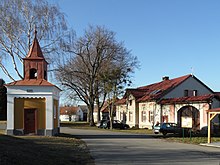
Spytice
| Spytice | ||||
|---|---|---|---|---|
|
||||
| Basic data | ||||
| State : |
|
|||
| Region : | Kraj Vysočina | |||
| District : | Havlíčkův Brod | |||
| Municipality : | Vilémov | |||
| Area : | 248 ha | |||
| Geographic location : | 49 ° 50 ' N , 15 ° 31' E | |||
| Height: | 314 m nm | |||
| Residents : | 72 (2011) | |||
| Postal code : | 582 82 | |||
| License plate : | J | |||
| traffic | ||||
| Street: | Vilémov - Zvěstovice | |||
Spytice (German Spititz ) is a district of the minor town Vilémov in the Czech Republic . It is located three kilometers north of Vilémov and belongs to the Okres Havlíčkův Brod .
geography
Spytice is located on a plateau between the valleys of the Hostačovka and Doubravka in the Hornosázavská pahorkatina ( hill country on the upper Sázava ). To the east rises the Na Hradci (343 m nm), in the south of the Šibeniční vrch (352 m nm). To the southwest lies the Jezuitský rybník pond, south of the Sirákovický rybník.
Neighboring towns are Biskupice , Kněžice and Mladotice in the north, Třemošnice and Moravany in the Northeast, Bučovice in the east, Heřmanice and Úhrov the southeast, Vilémov and Klášter in the south, Sirákovice in the southwest, Potěšilka, Jezuitský Mlyn, Na Doubravě and Stupárovice the west and Skryje , Hostačov and Zvěstovice in the north-west.
history
The first written mention of the village took place in 1369 under the property of the Benedictine monastery Wilmzell . After the monastery was destroyed by the Hussites in 1421 , Hertvík von Rušínov seized the village on Lichtenburg . Beneš Beneda from Nečtiny, who bought the Spytice estate at the end of the 16th century, who set up several farms. In the 17th century the fortress Spytice burned down and a new fortress was built in Zvěstovice instead. In the following period they changed hands frequently; For a while the village belonged to the Ronov nad Doubravou dominion , then the village was attached to the Jeníkov dominion . After the death of Martin Maximilian von der Goltz , the Jesuits introduced by him claimed the Sirákovice and Spytice estates in 1653 and received them for 30,000 guilders. In 1659 Johann Dietrich von Ledebur bought the goods Zvěstovice , Sirákovice and Spytice to the Jeníkov rule. After Ledebur was forced by the Jesuits in 1672 to comply with the Goltz legacy after a 16-year dispute, the Sirákovice and Spytice estates fell back to the order. In the course of the abolition of the Jesuit order , both estates became the property of the Bohemian crown in 1773 . Two years later, Queen Maria Theresa left the goods to the owner of the Goltsch-Jenikau estate , Leopold Kolowrat-Krakowský , for 20,000 guilders on the condition that they be provided with qualified pastors and teachers instead of the Jesuits.
In 1840 the village of Spititz , located in the Caslauer Kreis , consisted of 29 houses in which 170 people lived, including ten Protestant and one Jewish family. After Spititz was konskribiert the single inn Potieschilka . The Catholic parish was a monastery , the Protestants had their pastorate in Wilimow . Until the middle of the 19th century, Spititz remained subject to the Goltsch-Jenikau rule.
After the abolition of patrimonial Spytice formed from 1849 with the district Zvěstovice a municipality in the judicial district of Habern . From 1868 the place belonged to the Časlau district . In 1869 Spytice had 214 inhabitants and consisted of 29 houses. Zvěstovice broke away from Spytice in the 1870s and formed its own municipality. A two-class village school was built in the second half of the 19th century. In 1900 there were 194 people in Spytice, compared to 181 in 1910. In 1930 Spytice had 214 inhabitants and consisted of 35 houses. Since the territorial reform of 1960 the village has belonged to Okres Havlíčkův Brod . In 1961 it was incorporated into Zvěstovice and in 1976 to Skryje , since the beginning of 1989 the village has been part of Vilémov. In the 2001 census, 59 people lived in the 40 houses in the village. Today only 27 of the 41 houses are permanently inhabited.
Local division
The Na Doubravě and Potěšilka ( Potieschilka ) layers belong to Spytice . The district forms a cadastral district.
Attractions
- Chapel on the village square, built in 1888
- Several listed farmhouses.
- Celtic fort on the Na Hradci
literature
- Historický lexikon obcí České republiky 1869–2005 , part 1, p. 560
Web links
Individual evidence
- ↑ http://www.uir.cz/katastralni-uzemi/793884/Spytice
- ↑ https://www.golcuv-jenikov.cz/evt_file.php?file=593
- ^ Johann Gottfried Sommer : The Kingdom of Bohemia; Represented statistically and topographically. Volume 11: Caslauer Kreis. Ehrlich, Prague 1843, p. 296.
- ↑ http://www.uir.cz/katastralni-uzemi/793884/Spytice


